Dera Ghazi Khan Division

Last updated
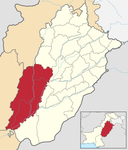
Dera Ghazi Khan Division
ڈیرہ غازی خان ڈویژن
Pakistan - Punjab - Dera Ghazi Khan (division).svg
Country Flag of Pakistan.svg  Pakistan
Province Flag of Punjab.svg Punjab
Capital Dera Ghazi Khan
Area
   Division
38,778 km2 (14,972 sq mi)
Population
 (2023) [1]
   Division
12,892,465
  Density332.47/km2 (861.1/sq mi)
   Urban
2,771,711 (21.50%)
   Rural
10,120,754
Literacy
[2]
  Literacy rate
  • Total:
    (48.00%)
  • Male:
    (56.48%)
  • Female:
    (39.20%)
Website dgkhandivision.punjab.gov.pk

Dera Ghazi Khan Division is an administrative division of the Punjab Province, Pakistan. The division was established in 1982.

Contents

History

During British rule, All the districts that later formed Dera Ghazi Khan Division, collectively formed a district of Multan Division. [3] Dera Ghazi Khan was made into a separate division in 1982. The division system was abolished in 2000 but restored in 2008 after the restoration of democracy in the country. [4]

List of the Districts

DistrictCapitalArea

(km²) [5]

Pop.

(2023)

Density

(ppl/km²)

(2023)

Lit. rate

(2023)

Taunsa Taunsa 8,108...240...
Kot Addu Kot Addu 3,471...390...
Layyah Layyah 6,2892,102,386334.561.83%
Dera Ghazi Khan Dera Ghazi Khan 3,8143,393,705285.846.78%
Muzaffargarh Muzaffargarh 4,7785,015,325607.547.99%
Rajanpur Rajanpur 12,3192,381,049193.336.09%

List of the Tehsils

TehsilArea

(km²) [5]

Pop.

(2023)

Density

(ppl/km²)

(2023)

Lit. rate

(2023) [6]

Districts
Dera Ghazi Khan 2,0121,443,409717.4047.25% Dera Ghazi Khan District
Kot Chutta 1,802904,836502.1338.61%
Muhammadpur ............ Jampur District
Jampur 2,3221,012,039435.8538.07%
Dajal ............
Jampur Tribal Area ............
Chowk Sarwar Shaheed 1,785414,578232.2655.50% Kot Addu District
Kot Addu 1,6861,072,180635.9358.19%
Karor Lal Esan 1,823684,729375.6162.43% Layyah District
Chaubara 2,754299,082108.6058.42%
Layyah 1,7121,118,575653.3762.34%
Jatoi 1,010862,046853.5140.67% Muzaffargarh District
Alipur 1,391760,526546.7539.15%
Muzaffargarh 2,3771,905,995801.8546.84%
Rojhan 2,905474,077163.1920.98% Rajanpur District
Rajanpur 2,078853,192410.5841.38%
De-Excluded Area Rajanpur 5,01341,741113.138.6%
Koh-e-Suleman 5,339248,68346.5836.04% Taunsa District
Taunsa 2,769796,777287.7557.96%
Vehowa ............

Demographics

Historical population
YearPop.±% p.a.
1951N/A    
1961N/A    
1972N/A    
1981N/A    
19986,503,590    
201711,014,398+2.81%
202312,892,465+2.66%
Sources: [7]

Population

The population of Dera Ghazi Khan division was 12,892,465 in 2023 census [8] which was roughly equal to the country of Bolivia [9] or the US state of Illinois. [10]

Constituencies

Provincial Assembly ConstituencyNational Assembly ConstituencyDistrict
PP-268 Muzaffargarh-I NA-175 Muzaffargarh-I Muzaffargarh
PP-269 Muzaffargarh-II
PP-270 Muzaffargarh-III NA-176 Muzaffargarh-II
PP-271 Muzaffargarh-IV
PP-272 Muzaffargarh-V NA-177 Muzaffargarh-III
PP-273 Muzaffargarh-VI
PP-274 Muzaffargarh-VII NA-178 Muzaffargarh-IV
PP-275 Muzaffargarh-VIII
PP-276 Kot Addu-I NA-179 Kot Addu-I Kot Addu
PP-278 Kot Addu-III
PP-277 Kot Addu-II NA-180 Kot Addu-II
PP-279 Layyah-I NA-181 Layyah-I Layyah
PP-280 Layyah-II
PP-281 Layyah-III
PP-282 Layyah-IV NA-182 Layyah-II
PP-283 Layyah-V
PP-284 Taunsa-I NA-183 Taunsa Taunsa
PP-285 Taunsa-II
PP-286 Dera Ghazi Khan-I NA-184 Dera Ghazi Khan-I Dera Ghazi Khan
PP-287 Dera Ghazi Khan-II
PP-288 Dera Ghazi Khan-III NA-185 Dera Ghazi Khan-II
PP-289 Dera Ghazi Khan-IV
PP-290 Dera Ghazi Khan-V NA-186 Dera Ghazi Khan-III
PP-291 Dera Ghazi Khan-VI
PP-292 Rajanpur-I NA-187 Rajanpur-I Rajanpur
PP-293 Rajanpur-II
PP-294 Rajanpur-III NA-188 Rajanpur-II
PP-295 Rajanpur-IV
PP-296 Rajanpur-V NA-189 Rajanpur-III
PP-297 Rajanpur-VI

See also

References

  1. "DISTRICT WISE CENSUS RESULTS CENSUS 2017" (PDF). www.pbscensus.gov.pk. Archived from the original (PDF) on 2017-08-29.
  2. "Literacy rate, enrolments, and out-of-school population by sex and rural/urban, CENSUS-2023" (PDF).
  3. Dera Ghāzi Khān District Imperial Gazetteer of India, v. 11, p. 248.
  4. "KHĀN". Gazetteer of the Persian Gulf, Oman and Central Arabia Online. Retrieved 2024-05-18.
  5. 1 2 "TABLE 1 : AREA, POPULATION BY SEX, SEX RATIO, POPULATION DENSITY, URBAN POPULATION, HOUSEHOLD SIZE AND ANNUAL GROWTH RATE, CENSUS-2023, PUNJAB" (PDF).
  6. "TABLE 12 : LITERACY RATE, ENROLMENT AND OUT OF SCHOOL POPULATION BY SEX AND RURAL/URBAN, CENSUS-2023, PUNJAB" (PDF).
  7. "Population by administrative units 1951-1998" (PDF). Pakistan Bureau of Statistics.
  8. "Announcement of Results of 7th Population and Housing Census-2023 'The Digital Census' | Pakistan Bureau of Statistics". www.pbs.gov.pk. Retrieved 2024-06-03.
  9. US Directorate of Intelligence. "Country Comparison:Population". Archived from the original on 13 June 2007. Retrieved 2011-10-01. Latvia 2,204,708, July 2011 est.
  10. "2010 Resident Population Data". U. S. Census Bureau. Archived from the original on 19 October 2013. Retrieved 2011-09-30. New Mexico - 2,059,179

30°28′N70°24′E / 30.467°N 70.400°E / 30.467; 70.400