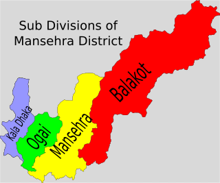
Bala Kot Tehsil is an administrative subdivision (tehsil) of Mansehra District in the Khyber-Pakhtunkhwa province of Pakistan.

Battagram District is a district in Hazara Division of Khyber Pakhtunkhwa province in Pakistan. The headquarter is Battagram town, which is about 75-km from Mansehra.
Belian is a village. It is located in Mansehra Tehsil and lies to the north east of the district capital Mansehra it lies in area affected by the 2005 Kashmir earthquake, it lies 60 km east of the epicentre of the 2005 Kashmir earthquake.
Chater Plain is a Union Council of Mansehra District in Khyber-Pakhtunkhwa province of Pakistan. It is part of Mansehra Tehsil and is located in an area that was affected by the 2005 Kashmir earthquake. Majority of the clans are Swati Pashtuns and Gujars.
Devli Jaberr is a Union Council of Mansehra District in the Khyber Pakhtunkhwa province of Pakistan. It lies in the north east of the district and is in an area that was affected by the 2005 Kashmir earthquake.
Inayatabad is a village and union council of Mansehra District in Khyber-Pakhtunkhwa province of Pakistan. It is located in Mansehra Tehsil and lies to the north of the district capital Mansehra and lies in area affected by the 2005 Kashmir earthquake.
Garhi Habibullah is a town and union council of Mansehra District in the Khyber-Pakhtunkhwa province of Pakistan. It is located in Mansehra Tehsil and lies to the east of the district capital Mansehra, towards the Kashmir frontier. It is in an area affected by the 2005 Kashmir earthquake.
Garlat is a village and union council of Mansehra District in the Khyber-Pakhtunkhwa province of Pakistan. It is located in Balakot tehsil and lies in an area that was affected by the 2005 Kashmir earthquake.
Satbani is a village and union council of Mansehra District in the Khyber-Pakhtunkhwa province of Pakistan. It is located in Balakot tehsil and lies in an area that was affected by the 2005 Kashmir earthquake. On 3 September 2007, survivors of the earthquake from Satbani, Ghanool, Garlat and Kawai Union Councils organised a protest in Satbani against the authorities for the delay in compensation.
Ghanool is a village and union council of Mansehra District in the Khyber-Pakhtunkhwa province of Pakistan. It is located in Balakot tehsil and lies in an area that was affected by the 2005 Kashmir earthquake. UC Ghanool has four village councils i.e Ghanool, Sangar-1, Sangar-2 and Bhangian. Sangar is most populous area of Ghanool with Madakhel in majority.
Dilbori is a village and union council of Mansehra District in Khyber Pakhtunkhwa province of Pakistan. It lies in area affected by the 2005 Kashmir earthquake.
Hangrai is a village and union council of Mansehra District in the Khyber-Pakhtunkhwa province of Pakistan. It is located in the lower Kaghan Valley and lies to the north of Balakot city in an area that was affected by the 2005 Kashmir earthquake.
Hilkot is a village and union council of Mansehra District in the Khyber Pakhtunkhwa province of Pakistan. It is located to the north of Mansehra the district capital and south west of Batagram city and lies in an area affected by the 2005 Kashmir earthquake. Total Number of Village Councils 4.Village Council Kund Bala/Sathan Gali/Hilkot/Balimang.Spoken language is Gojri.
Icherrian is a village and union council of Mansehra District in the Khyber Pakhtunkhwa province of Pakistan. It is located to the north east of Mansehra the district capital and lies in an area affected by the 2005 Kashmir earthquake.

Karnol is a village and union council of Mansehra District in the Khyber-Pakhtunkhwa province of Pakistan. It is located at 34°23′N73°23′E at an altitude of 797 metres (2618 feet) lying in the south east of the district near to Abbottabad and the Kashmir frontier and lies in an area affected by the 2005 Kashmir earthquake.
Karorri is a village and union council of Mansehra District in the Khyber Pakhtunkhwa Province of Pakistan. It is located in the west of the district and lies in an area affected by the 2005 Kashmir earthquake.
Kathai is a village and union council of Mansehra District in Khyber Pakhtunkhwa province of Pakistan. It lies in an area affected by the 2005 Kashmir earthquake.
Kawai is a village and union council of Mansehra District in the Khyber-Pakhtunkhwa province of Pakistan. It is located in the north east of the district and lies in an area that was affected by the 2005 Kashmir earthquake.
LabarKot is a village and union council of Mansehra District in the Khyber Pakhtunkhwa province of Pakistan. It is located in the south of the district and is to the north-east of Mansehra the district capital, in an area affected by the 2005 Kashmir earthquake.
Mohandri is a village and union council of Mansehra District in the Khyber-Pakhtunkhwa province of Pakistan. It is located in the north east of the district and borders the Neelum and Muzaffarabad districts of Azad Kashmir and lies in an area affected by the 2005 Kashmir earthquake.

