Related Research Articles
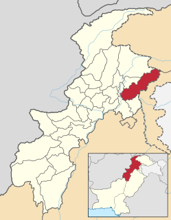
Mansehra District is a district in Hazara Division of Khyber Pakhtunkhwa province in Pakistan. Mansehra district and town are named after the Sikh Khalsa Army general Mahan Singh Mirpuri, who founded the city. It is an important and popular tourist destination due to the Lulusar-Dudipatsar National Park and Kaghan Valley area being located in the district and the Karakoram Highway passing through the district. It is main gateway to upper valleys of Kaghan, Naran and also to Gilgit-Baltistan and Azad Kashmir.
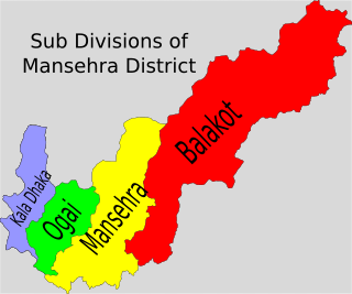
Bala Kot Tehsil is an administrative subdivision (tehsil) of Mansehra District in the Khyber-Pakhtunkhwa province of Pakistan. Balakot is the main city of this area. It was one of the towns which was most damaged in the 2005 Kashmir earthquake on 8 October 2005 and an estimated 80% of the buildings there were destroyed. Villages were badly affected and landslides cut off thousands of people from Balakot where relief workers had been helping the survivors.
Chater Plain is a Union Council of Mansehra District in Khyber-Pakhtunkhwa province of Pakistan. It is part of Mansehra Tehsil and is located in an area that was affected by the 2005 Kashmir earthquake. Majority of the clans are Swati Pashtuns and Gujars.
Devli Jaberr is a Union Council of Mansehra District in the Khyber Pakhtunkhwa province of Pakistan. It lies in the north east of the district and is in an area that was affected by the 2005 Kashmir earthquake.
Inayatabad is a village and union council of Mansehra District in Khyber-Pakhtunkhwa province of Pakistan. It is located in Mansehra Tehsil and lies to the north of the district capital Mansehra and lies in area affected by the 2005 Kashmir earthquake.
Garlat is a village and union council of Mansehra District in the Khyber-Pakhtunkhwa province of Pakistan. It is located in Balakot tehsil and lies in an area that was affected by the 2005 Kashmir earthquake.
Satbani is a village and union council of Mansehra District in the Khyber-Pakhtunkhwa province of Pakistan. It is located in Balakot tehsil and lies in an area that was affected by the 2005 Kashmir earthquake. On 3 September 2007, survivors of the earthquake from Satbani, Ghanool, Garlat and Kawai Union Councils organised a protest in Satbani against the authorities for the delay in compensation.
Ghanool is a village and union council of Mansehra District in the Khyber-Pakhtunkhwa province of Pakistan. It is located in Balakot tehsil and lies in an area that was affected by the 2005 Kashmir earthquake. UC Ghanool has four village councils i.e. Ghanool, Sangar-1, Sangar-2 and Bhangian. Sangar is most populous area of Ghanool with Madakhel in majority.Paya, which is also known as Sari and Paya, is a meadow at the height of more than 9000 feet the area which is full of thick pine forests/wild alpine flowers and Makra Mountain which is 12743 feet above the sea level is also part of Ghanool. Tribes living in Ghanool includes Mughals, Rajputs, Awans and Madakhels, which makes Ghanool a land with diversified people. Its one of educated valley of Mansehra district and well known for hospitality of its people
Dilbori is a village and union council of Mansehra District in Khyber Pakhtunkhwa province of Pakistan. It lies in area affected by the 2005 Kashmir earthquake.
Humsherian is a small village and union council of Mansehra District in the Khyber Pakhtunkhwa province of Pakistan. It lies just south of Bherkund and north west of the district capital Mansehra in an area affected by the 2005 Kashmir earthquake.
Hangrai is a village and union council of Mansehra District in the Khyber-Pakhtunkhwa province of Pakistan. It is located in the lower Kaghan Valley and lies to the north of Balakot city in an area that was affected by the 2005 Kashmir earthquake.
Hilkot is a village and union council of Mansehra District in the Khyber Pakhtunkhwa province of Pakistan. It is located to the north of Mansehra the district capital and south east of Batagram city and lies in an area affected by the 2005 Kashmir earthquake. There are 04 village councils. Village Council 1. Hilkot 2. Kund Bala 3. Sathan Gali 4. Balimang. Spoken languages are Pashto, Gojri & Hindko. Major Castes are Swati & Gujjar. V/C Kund Bala & Sathan Gali have mostly people from Gujjar family which is totally hilly area while V/C Hilkot & Balimang have mostly people from Swati & Syed family. There are green field and most of land is hilly occupied with forests. Main crops are maize, wheat & little bit rice. In fruits there are Orchards & Trees of Apple, Apricot, Pear, Plums & Date-plum. Natural water rich in herbs comes from hills. The literacy rate is growing gradually. There are difficulties that the local population faces the lack of proper healthcare facilities in the area, as there are no hospitals in the region & Also there is no any Govt boys or girls college. Mostly people moved for jobs & businesses and support their families & serving in different departments of country & abroad. Farming is only way of earning but due to hilly area and weather conditions its not fulfill requirements of area.
Icherrian is a village and union council of Mansehra District in the Khyber Pakhtunkhwa province of Pakistan. It is located to the north east of Mansehra the district capital and lies in an area affected by the 2005 Kashmir earthquake.

Karnol is a village and union council of Mansehra District in the Khyber-Pakhtunkhwa province of Pakistan. It is located at 34°23′N73°23′E at an altitude of 797 metres (2618 feet) lying in the south east of the district near to Abbottabad and the Kashmir frontier and lies in an area affected by the 2005 Kashmir earthquake.
Karori (کروڑی) is a Town and union council of Mansehra District in the Khyber Pakhtunkhwa Province of Pakistan. It is located in the west of the district and lies in an area affected by the 2005 Kashmir earthquake.
Kathai is a village and union council of Mansehra District in Khyber Pakhtunkhwa province of Pakistan. It lies in an area affected by the 2005 Kashmir earthquake.
Kawai is a village and union council of Mansehra District in the Khyber-Pakhtunkhwa province of Pakistan. It is located in the north east of the district and lies in an area that was affected by the 2005 Kashmir earthquake.
LabarKot is a village and union council of Mansehra District in the Khyber Pakhtunkhwa province of Pakistan. It is located in the south of the district and is to the north-east of Mansehra the district capital, in an area affected by the 2005 Kashmir earthquake.

Peeran is a village and union council of Mansehra District in the Khyber-Pakhtunkhwa province of Pakistan. It is located in District Mansehra. It is in an area affected by the 2005 Kashmir earthquake.
Talhatta is a village and union council of Mansehra District Kaghan Valley, in the Khyber-Pakhtunkhwa province of Pakistan. It is located in the south of the district where its borders Slightly touches Kashmir. River Kunhar's (کُنہار) Sloping water also passes through Talhatta, River's Water is coming from Snowy peaks of Naran & Kaghan. Talhatta is a large village of Sadaats & having Separate position of Sadaat in District Mansehra. Sadaats of Talhatta are the Descendants of Pir Baba Boner Swat. Syed Qutab Shah Was the Founder of Talhatta,s Sadaats. Talhatta is categorized in four centrally Mohalla jaat, Named, Mastajir Mohalla, Masjid mohalla, Kashkar & apper Mohalla.
References
| This Mansehra District location article is a stub. You can help Wikipedia by expanding it. |