Daud Shah

Last updated
Daud Shah
Union council and town
Country Pakistan
Region Khyber Pakhtunkhwa
District Mansehra District
Time zone PST (UTC+5)

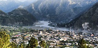
Daud Shah is a village and union council (an administrative subdivision) of Mansehra District in Khyber Pakhtunkhwa province of Pakistan. [1]

A Union Council forms the second-tier of local government and fifth administrative division in Pakistan. Its structure and responsibilities differ between provinces and territories.

Mansehra District District in Khyber Pakhtunkhwa, Pakistan

Mansehra District is a district in Hazara Division of Khyber Pakhtunkhwa province in Pakistan. Mansehra district and town are named after Man Singh, a leading general of Mughal Emperor Akbar. It is an important and popular tourist destination due to the Lulusar-Dudipatsar National Park and Kaghan Valley area being located in the district and the Karakoram Highway passing through the district. It is main gateway to upper valleys of Kaghan, Naran and also to Gilgit-Baltistan and Azad Kashmir.

Khyber Pakhtunkhwa Province in Pakistan

Khyber Pakhtunkhwa is one of the four administrative provinces of Pakistan, located in the northwestern region of the country along the international border with Afghanistan. It was previously known as the North-West Frontier Province (NWFP) until 2010 when the name was changed to Khyber Pakhtunkhwa by the 18th Amendment to Pakistan's Constitution, and is known colloquially by various other names. Khyber Pakhtunkhwa is the third-largest province of Pakistan by the size of both population and economy, though it is geographically the smallest of four. Within Pakistan, Khyber Pakhtunkhwa shares a border with Punjab, Balochistan, Azad Kashmir, Gilgit-Baltistan, and Islamabad. It comprises 10.5% of Pakistan's economy, and is home to 17.9% of Pakistan's total population, with the majority of the province's inhabitants being Pashtuns. The province is the site of the ancient kingdom Gandhara, including the ruins of its capital Pushkalavati near modern-day Charsadda. Originally a stronghold of Buddhism, the history of the region was characterized by frequent invasions under various Empires due to its geographical proximity to the Khyber Pass.
Related Research Articles

Dhodial is a town and union council located near Baffa between Mansehra and Shinkiari in Mansehra District in Khyber Pakhtunkhwa province of Pakistan. Dhodial is a fertile region known for its vegetables and tobacco. Dhodial is also well known for its pheasant conservation project.The town was badly affected by the 2005 Pakistan earthquake.

Garhi Habibullah Union council and town in Khyber-Pakhtunkhwa, Pakistan

Garhi Habibullah is a town and union council of Mansehra District in the Khyber-Pakhtunkhwa province of Pakistan. It is located in Mansehra Tehsil and lies to the east of the district capital Mansehra, towards the Kashmir frontier. It is in an area affected by the 2005 Kashmir earthquake.

Garlat is a village and union council of Mansehra District in the Khyber-Pakhtunkhwa province of Pakistan. It is located in Balakot tehsil and lies in an area that was affected by the 2005 Kashmir earthquake.

Icherrian is a village and union council of Mansehra District in the Khyber Pakhtunkhwa province of Pakistan. It is located to the north east of Mansehra the district capital and lies in an area affected by the 2005 Kashmir earthquake.

Kathai is a village and union council of Mansehra District in Khyber Pakhtunkhwa province of Pakistan. It lies in an area affected by the 2005 Kashmir earthquake.

LabarKot is a village and union council of Mansehra District in the Khyber Pakhtunkhwa province of Pakistan. It is located in the south of the district and is to the north-east of Mansehra the district capital, in an area affected by the 2005 Kashmir earthquake.

Lassan Thakral is a village and union council of Mansehra District in Khyber-Pakhtunkhwa province of Pakistan. It is located in the south of Mansehra district where it borders Abbottabad District.

Malik Pur is a village and union council of Mansehra District in the Khyber Pakhtunkhwa province of Pakistan. It is located to the north east the district capital Mansehra.

Mansehra (Rural) is a Union Council of Mansehra District in Khyber-Pakhtunkhwa province of Pakistan. It is located in the south of the district and to the southeast of the district capital, Mansehra.

Mohandri is a village and union council of Mansehra District in the Khyber-Pakhtunkhwa province of Pakistan. It is located in the north east of the district and borders the Neelum and Muzaffarabad districts of Azad Kashmir and lies in an area affected by the 2005 Kashmir earthquake.

Nika Pani is a village and union council of Mansehra District in Khyber-Pakhtunkhwa province of Pakistan. It is located in the east of the district.

Perhana is a village and union council of Mansehra District in the Khyber Pakhtunkhwa Province of Pakistan. It is located in the south of the district and lies to the west of the district capital Mansehra.

Phulrraa is a village and union council of Mansehra District in Khyber-Pakhtunkhwa province of Pakistan. It is located in the south of the district and lies to the west of the district capital Mansehra.

Sandasar is a village and union council of Mansehra District in the Khyber Pakhtunkhwa Province of Pakistan. It is located in the south of the district and lies to the west of the district capital Mansehra.

Shoukatabad is a Union Council of Mansehra District in Khyber-Pakhtunkhwa province of Pakistan. It is located to the north-west of the district capital Mansehra.

Swan Miara is a village and union council of Mansehra District in Khyber-Pakhtunkhwa province of Pakistan. It is located in the south of the district where it borders Abbottabad District.

Trangi Sabir Shah is a village and union council of Mansehra District in Khyber-Pakhtunkhwa province of Pakistan. It is located to the north of the district capital Mansehra.

Mansehra Tehsil is a tehsil in Mansehra District, Khyber Pakhtunkhwa, Pakistan.

References

The total distance from the road is 3 km