Related Research Articles

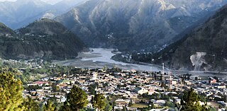
Battagram is a tribal district in Hazara Division of Khyber Pakhtunkhwa province in Pakistan. The headquarter is Battagram, which is about 75 km from Mansehra city. It was part of historic Yaghistan before 1955. Later in 1955, It was merged into Pakistan and made part of neighboring Mansehra District with the status of Tehsil. It was officially separated from Mansehra District in July 1993 and was given the status of district. Battagram District was ruled by many different Khans, all belonging to the Swati tribe.
Dhodial is an important town and union council located near Baffa between Mansehra and Shinkiari in Mansehra District in Khyber Pakhtunkhwa province of Pakistan. Dhodial is a fertile region known for its vegetables and tobacco crop. Dhodial is also well known for its pheasant conservation project. The town was badly affected by the 2005 Pakistan earthquake.
Chattar Plain is a Union Council of Mansehra District in Khyber-Pakhtunkhwa province of Pakistan. It is part of Mansehra Tehsil and is located in an area that was affected by the 2005 Kashmir earthquake. Land Lords of Chattar Plain belongs to Swatis and Sadaat Family. It is the highest plain point in the mountain regions starting from abbottabad to gilgit.
Inayatabad is a village and union council of Mansehra District in Khyber-Pakhtunkhwa province of Pakistan. It is located in Mansehra Tehsil and lies to the north of the district capital Mansehra and lies in area affected by the 2005 Kashmir earthquake.
Garhi Habibullah Khan is a small city and union council of Mansehra District in the Khyber-Pakhtunkhwa province of Pakistan. It is named after Khan Habibullah Khankhail Swati, the Khan of Garhi and Chief of Swati tribe from 1810 to 1830. It is located in Balakot Tehsil and lies to the east of district capital Mansehra, towards the Kashmir frontier. It was affected by the 2005 Kashmir earthquake.
Garlat is a village and union council of Mansehra District in the Khyber-Pakhtunkhwa province of Pakistan. It is located in Balakot tehsil and lies in an area that was affecteded by the 2005 Kashmir earthquake. HASSA is famous village council of Garlat.
Satbani is a village and union council of Mansehra District in the Khyber-Pakhtunkhwa province of Pakistan. It is located in Balakot tehsil and lies in an area that was affected by the 2005 Kashmir earthquake. On 3 September 2007, survivors of the earthquake from Satbani, Ghanool, Garlat and Kawai Union Councils organised a protest in Satbani against the authorities for the delay in compensation.
Ghanool is a village and union council of Mansehra District in the Khyber-Pakhtunkhwa province of Pakistan. It is located in Balakot tehsil and lies in an area that was affected by the 2005 Kashmir earthquake. The union council of Ghanool has four village councils: Ghanool, Sangar-1, Sangar-2, and Bhangian. Sangar is the most populous area of Ghanool with the majority of the population belonging to the Madakhel tribe. Paya, which is also known as Sari and Paya, is a meadow at a height of more than 9000 feet. Makra Peak, a mountain 3885 meters above sea level is located in Ghanool. Tribes living in Ghanool include Mughals Barlas, Rajputs, Awans, Swati, and Madakhels.
Dilbori is a village and union council of Mansehra District in Khyber Pakhtunkhwa province of Pakistan. It lies in area affected by the 2005 Kashmir earthquake. Swati is the most influential tribe of this area.
Humsherian is a small village and union council of Mansehra District in the Khyber Pakhtunkhwa province of Pakistan. It lies just south of Bherkund and north west of the district capital Mansehra in an area affected by the 2005 Kashmir earthquake.
Hangrai is a village and union council of Mansehra District in the Khyber-Pakhtunkhwa province of Pakistan. It is located in the lower Kaghan Valley and lies to the north of Balakot city in an area that was affected by the 2005 Kashmir earthquake.
Hilkot is a village and union council of Mansehra District in the Khyber Pakhtunkhwa province of Pakistan. It is located to the north of Mansehra the district capital and south east of Batagram city and lies in an area affected by the 2005 Kashmir earthquake. There are 04 village councils. Village Council 1. Hilkot 2. Kund Bala 3. Sathan Gali 4. Balimang. Spoken languages are Pashto, Gojri & Hindko. Major Castes are Swati & Gujjar. V/C Kund Bala & Sathan Gali have mostly people from Gujjar family which is totally hilly area while V/C Hilkot & Balimang have mostly people from Swati & Syed family. There are green field and most of land is hilly occupied with forests. Main crops are maize, wheat & little bit rice. In fruits there are Orchards & Trees of Apple, Apricot, Pear, Plums & Date-plum. Natural water rich in herbs comes from hills. The literacy rate is growing gradually. There are difficulties that the local population faces the lack of proper healthcare facilities in the area, as there are no hospitals in the region & Also there is no any Govt boys or girls college. Mostly people moved for jobs & businesses and support their families & serving in different departments of country & abroad. Farming is only way of earning but due to hilly area and weather conditions its not fulfill requirements of area.
Icherrian is a village and union council of Mansehra District in the Khyber Pakhtunkhwa province of Pakistan. It is located to the north east of Mansehra the district capital and lies in an area affected by the 2005 Kashmir earthquake.
Karori (کروڑی) is a Town and union council of Mansehra District in the Khyber Pakhtunkhwa Province of Pakistan. It is located in the west of the district and lies in an area affected by the 2005 Kashmir earthquake.
Kathai is a village and union council of Mansehra District in Khyber Pakhtunkhwa province of Pakistan. It lies in an area affected by the 2005 Kashmir earthquake.
Kawai is a village and union council of Mansehra District in the Khyber-Pakhtunkhwa province of Pakistan. It is located in the northeast of the district on the side of Ghanool and lies in an area that was affected by the 2005 Kashmir earthquake.
LabarKot is a village and union council of Mansehra District in the Khyber Pakhtunkhwa province of Pakistan. It is located in the south of the district and is to the north-east of Mansehra the district capital, in an area affected by the 2005 Kashmir earthquake.
Mohandri is a village and union council of Mansehra District in the Khyber-Pakhtunkhwa province of Pakistan. It is located in the north east of the district and borders the Neelum and Muzaffarabad districts of Azad Kashmir. It lies in an area affected by the 2005 Kashmir earthquake.
Shohal Mazullah Khan is a village and union council of Mansehra District in the Khyber-Pakhtunkhwa province of Pakistan. It is located at the bank of River Kuhnar, in the east of the District Mansehra, about 7 km to Balakot and it borders Muzaffarabad District and lies in an area affected by the 2005 Kashmir earthquake.
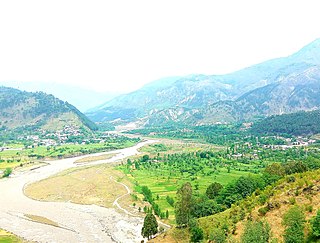
Battagram Tehsil is an administrative subdivision (Tehsil) of the Battagram District in the Khyber Pakhtunkhwa province of Pakistan. It serves as the Tehsil headquarters and covers a total area of 300 square miles (780 km2). Battagram Tehsil merged into Pakistan as an administrative region before being raised to the status of a district in 1993. On October 8, 2005, a 7.6 magnitude earthquake in Kashmir badly affected the area.
References
| | This Mansehra District location article is a stub. You can help Wikipedia by expanding it. |