Related Research Articles

Abbottabad District is a district of the Pakistani province of Khyber Pakhtunkhwa. It is part of Hazara Division and covers an area of 1,969 km2, with the city of Abbottabad being the principal town. Neighbouring districts are Mansehra to the north, Muzaffarabad to the east, Haripur to the west, and Rawalpindi to the south.

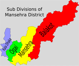
Mansehra District is a district in Hazara Division of Khyber Pakhtunkhwa province in Pakistan. It is main gateway to upper valleys of Kaghan, Naran and also to Gilgit-Baltistan and Azad Kashmir.
Tanda is a village in the Mansehra District of the Khyber Pakhtunkhwa province of Pakistan. It is also the administrative centre of Tanda Union Council, a subdivision of Mansehra Tehsil. It is located at 34°29′N73°18′E at an elevation of 1037 metres. Most of the inhabitants are of the Swati tribe, subsection Gabri styled as 'Mirs' and known as Panjghols.

Battagram is a district in Hazara Division of Khyber Pakhtunkhwa province in Pakistan. The headquarter is Battagram, which is about 75-km from Mansehra.

Baffa is a town, a union council and capital of Tehsil Baffa Pakhal of Mansehra District in the Khyber-Pakhtunkhwa, Pakistan. It lies about 15 km north of the district capital, Mansehra.

Bal Dheri is one of the 51 union councils of Abbottabad District in Khyber-Pakhtunkhwa province of Pakistan, the union council of Baldheri is named after the main village of the area. The population of Baldheri Union Council is 14,796.
Oghi is a tehsil in Mansehra District, in the Khyber Pakhtunkhwa province of Pakistan. Its territory largely coincides with the Agror Valley, and its headquarters is the town of Oghi.
Dhodial is a town and union council located near Baffa between Mansehra and Shinkiari in Mansehra District in Khyber Pakhtunkhwa province of Pakistan. Dhodial is a fertile region known for its vegetables and tobacco. Dhodial is also well known for its pheasant conservation project. The town was badly affected by the 2005 Pakistan earthquake.
Bahali is a village and union council of the Mansehra District in Khyber-Pakhtunkhwa province of Pakistan. Bahali is part of Mansehra Tehsil and is located at the boundary area of the Mansehra district and the Abbottabad district, west from the Karakurram highway at Qalanderabad. It is a valley surrounded by mountains. It is inhabited by Turki, Tanolies,Awan, Gujjar, Syeds And Galye.
Inayatabad is a village and union council of Mansehra District in Khyber-Pakhtunkhwa province of Pakistan. It is located in Mansehra Tehsil and lies to the north of the district capital Mansehra and lies in area affected by the 2005 Kashmir earthquake.
Garlat is a village and union council of Mansehra District in the Khyber-Pakhtunkhwa province of Pakistan. It is located in Balakot tehsil and lies in an area that was affected
Satbani is a village and union council of Mansehra District in the Khyber-Pakhtunkhwa province of Pakistan. It is located in Balakot tehsil and lies in an area that was affected by the 2005 Kashmir earthquake. On 3 September 2007, survivors of the earthquake from Satbani, Ghanool, Garlat and Kawai Union Councils organised a protest in Satbani against the authorities for the delay in compensation.
Hangrai is a village and union council of Mansehra District in the Khyber-Pakhtunkhwa province of Pakistan. It is located in the lower Kaghan Valley and lies to the north of Balakot city in an area that was affected by the 2005 Kashmir earthquake.
Hilkot is a village and union council of Mansehra District in the Khyber Pakhtunkhwa province of Pakistan. It is located to the north of Mansehra the district capital and south east of Batagram city and lies in an area affected by the 2005 Kashmir earthquake. There are 04 village councils. Village Council 1. Hilkot 2. Kund Bala 3. Sathan Gali 4. Balimang. Spoken languages are Pashto, Gojri & Hindko. Major Castes are Swati & Gujjar. V/C Kund Bala & Sathan Gali have mostly people from Gujjar family which is totally hilly area while V/C Hilkot & Balimang have mostly people from Swati & Syed family. There are green field and most of land is hilly occupied with forests. Main crops are maize, wheat & little bit rice. In fruits there are Orchards & Trees of Apple, Apricot, Pear, Plums & Date-plum. Natural water rich in herbs comes from hills. The literacy rate is growing gradually. There are difficulties that the local population faces the lack of proper healthcare facilities in the area, as there are no hospitals in the region & Also there is no any Govt boys or girls college. Mostly people moved for jobs & businesses and support their families & serving in different departments of country & abroad. Farming is only way of earning but due to hilly area and weather conditions its not fulfill requirements of area.

Karnol is a village and union council of Mansehra District in the Khyber-Pakhtunkhwa province of Pakistan. It is located at 34°23′N73°23′E at an altitude of 797 metres (2618 feet) lying in the south east of the district near to Abbottabad and the Kashmir frontier and lies in an area affected by the 2005 Kashmir earthquake.
Lassan Thakral is a village and union council of Mansehra District in Khyber-Pakhtunkhwa province of Pakistan. It is located in the south of Mansehra district where it borders Abbottabad District.
Peeran is a village and union council of Mansehra District in the Khyber-Pakhtunkhwa province of Pakistan. It is located in District Mansehra. It is in an area affected by the 2005 Kashmir earthquake.
Shohal Mazullah Khan is a village and union council of Mansehra District in the Khyber-Pakhtunkhwa province of Pakistan. It is located at the bank of River Kuhnar, in the east of the District Mansehra, about 7 km to Balakot and it borders Muzaffarabad District and lies in an area affected by the 2005 Kashmir earthquake.
Jaloo is a village and union council of Mansehra District in Khyber-Pakhtunkhwa province of Pakistan. It is located in Mansehra Tehsil at 34°19'0N 73°9'0E and has an altitude of 1008 metres (3310).
Kuza Banda is a town, and one of twenty union councils in Battagram District in Khyber Pakhtunkhwa province of Pakistan. It is located at 34°38'5N 73°2'30E and has an altitude of 1425 metres (4678 feet). It is linked with the union council town of Battagram, and also to Oghi Tehsil of Mansehra District, by Oghi road, which has been connected with the traditional silk route since ancient times.
References
- ↑ Tehsils & Unions in the District of Mansehra - Government of Pakistan Casts in majority living in Datta are Syed,Peerzada,Awan,Tanoli,GujjarArchived July 18, 2011, at the Wayback Machine
34°17′N73°15′E / 34.283°N 73.250°E Coordinates: 34°17′N73°15′E / 34.283°N 73.250°E
| | This Mansehra District location article is a stub. You can help Wikipedia by expanding it. |
The Union Council Datta consists of five (5) villages: 1- Chakia 2- Datta 3- Ghazikot 4- Haryala 5- Khushala