Swabi District

Last updated

Swabi District
ضلع صوابی
سوابۍ ولسوالۍ
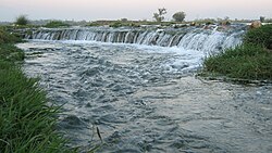
Sunset Jalbai.jpg
River Kundal at Maini.JPG
Top: Sunset at Jalbai at Maini
Bottom: Kunal River
Swabi District Locator.png
Swabi District (red) in Khyber Pakhtunkhwa
Country Flag of Pakistan.svg  Pakistan
Province PK-NWFP.svg  Khyber Pakhtunkhwa
Division Mardan
Headquarters Swabi
Government
  TypeDistrict Administration
   Deputy Commissioner Gohar Ali Khan
  District Police OfficerHaroon Rasheed Khan
  District Health OfficerDr Abdul Latif
Area
  Total
1,543 km2 (596 sq mi)
Population
 (2023) [1]
  Total
1,894,600
  Density1,200/km2 (3,200/sq mi)
   Urban
339,670 (17.93%)
   Rural
1,554,930
Time zone UTC+5 (PST)
Number of Tehsils 4
Website swabi.kp.gov.pk

Swabi District (Pashto : سوابۍ ولسوالۍ) is a district in the Mardan Division of the Khyber Pakhtunkhwa province in Pakistan. It lies between the Indus and Kabul Rivers. Before becoming a district in 1988, it was a tehsil within the Mardan District. [2] 96% of the population speaks Pashto as their first language. [3]

Contents

The dominating tribe of Swabi is the Yusufzai, followed by the minor Utmankhel, Lodi, Tarakai, Jadoon and Khattak. [4] [5]

Demographics

Historical population
YearPop.±% p.a.
1951 272,279    
1961 332,543+2.02%
1972 507,631+3.92%
1981 625,035+2.34%
1998 1,026,804+2.96%
2017 1,625,477+2.45%
2023 1,894,600+2.59%
Sources: [6]

As of the 2023 census, Swabi district has 278,976 households and a population of 1,894,600. The district has a sex ratio of 102.51 males to 100 females and a literacy rate of 58.48%: 72.34% for males and 44.50% for females. 519,863 (27.50% of the surveyed population) are under 10 years of age. 339,670 (17.93%) live in urban areas. [1]

Religion in Swabi District
Religion1941 [7] [a] 2017 [8] 2023 [9]
Pop.%Pop.%Pop.%
Islam Star and Crescent.svg 202,41497.71%1,624,39199.93%1,885,37999.74%
Sikhism Khanda.svg 2,7471.33%57~0%
Hinduism Om.svg 1,9680.95%880.01%800.01%
Christianity Christian cross.svg 160.01%5420.03%4,6080.24%
Others10~0%4560.03%1060.01%
Total Population207,155100%1,625,477100%1,890,230 [b] 100%

Languages of Swabi district (2023) [10]

   Pashto (97.23%)
   Hindko (2.05%)
  Others (0.72%)

At the time of the 2023 census, 97.23% of the population spoke Pashto and 2.05% Hindko as their first language. [10]

Education

Swabi District is now home to many excellent educational institutes. But there was no public sector university until 2012. The only degree awarding institution then was private sector Ghulam Ishaq Khan Institute of Engineering Sciences and Technology, which was inaugurated in 1993. [11] In 2012, the Government of Khyber Pakhtunkhawa established the first public sector university in Swabi, when it upgraded Abdul Wali Khan University Mardan Swabi campus into full-flege University of Swabi [12] [13] while Women University Swabi [14] was established in 2016. Swabi district also has a public sector medical college Gajju Khan Medical College Swabi, [15] which was established in 2014. [16]

The district also has 2 public sector Postgraduate degree colleges: Government Postgraduate College Swabi [17] and Govt Girls Post Graduate College Maneri Swabi. [18]

Administration

Swabi District is currently subdivided into 4 Tehsils. [19]

Provincial Assembly

Member of Provincial AssemblyParty AffiliationConstituencyYear
Rangez Ahmad Pakistan Tehreek-e-Insaf PK-46 Swabi-I 2018
Aqibullah Khan Pakistan Tehreek-e-Insaf PK-47 Swabi-II 2018
Abdul Karim Khan Pakistan Tehreek-e-Insaf PK-48 Swabi-III 2018
Muhammad Ali Tarakai Pakistan Tehreek-e-Insaf PK-49 Swabi-IV 2018
Shahram Khan Tarakai Pakistan Tehreek-e-Insaf PK-50 Swabi-V 2018

Newspaper in Swabi

Currently there are couple of newspaper publishing in Swabi under the supervision of the Swabi Group of Newspapers.

Notable people

Related Research Articles

<span class="mw-page-title-main">Bannu District</span> District in Pakistan

Bannu District is a district in the Bannu Division of the Khyber Pakhtunkhwa province of Pakistan. Its status as a district was formally recorded in 1861 during the British Raj.

<span class="mw-page-title-main">Dera Ismail Khan District</span> District sub-division in Pakistan

Dera Ismail Khan District, often abbreviated as D.I. Khan is a district in the Dera Ismail Khan division of the Khyber Pakhtunkhwa province of Pakistan. The capital of the district is the town of Dera Ismail Khan. The district has an area of 9,334 km2 (3,604 sq mi) and a population of 1,822,916 as of the 2023 Census. After the Second Anglo-Sikh war in 1849 the district was annexed by the British as part of the Punjab and remained so until 1901 when NWFP Khyber Pakhtunkhwa was created.

<span class="mw-page-title-main">Haripur District</span> Districts in Pakistan

Haripur District is a district in the Hazara Division of Khyber Pakhtunkhwa, Pakistan. Before obtaining the status of a district in 1991, Haripur was a tehsil of Abbottabad District Its headquarters are the city of Haripur. According to 2023 Pakistani census population of Haripur District is 1,173,056.

<span class="mw-page-title-main">Mardan District</span> District in Khyber Pakhtunkhwa, Pakistan

Mardan District is a district in the Mardan Division of the Khyber Pakhtunkhwa province of Pakistan. The district is named after Mardan city, which is also the headquarters of the district. The district is famous for its agriculture industry and its archaeological sites, specifically of Takht-i-Bhai, Jamal Garhi and Sawal Dher.

<span class="mw-page-title-main">Mansehra District</span> District in Khyber Pakhtunkhwa, Pakistan

Mansehra District is a district in the Hazara Division, Khyber Pakhtunkhwa, northern Pakistan. Mansehra city serves as the headquarters of the district. The district has a Hindkowan majority, with a significant Pashtun and Kohistani population.

<span class="mw-page-title-main">Nowshera District</span> District of Khyber Pakhtunkhwa in Pakistan

Nowshera District is a district in the Peshawar Division of the Khyber Pakhtunkhwa province of Pakistan. The capital and district headquarter is Nowshera city.

<span class="mw-page-title-main">Peshawar District</span> District of Khyber Pakhtunkhwa in Pakistan

Peshawar District is a district in the Peshawar Division of the Khyber Pakhtunkhwa province of Pakistan. It is located about 160 km west of the Pakistan's capital Islamabad. The district headquarter is the city of Peshawar, which is also the capital of Khyber Paktunkhwa.

<span class="mw-page-title-main">Shangla District</span> District of Khyber Pakhtunkhwa in Pakistan

Shangla District is a district in Malakand Division of Khyber Pakhtunkhwa, Pakistan. The district's headquarters are located at Alpuri, while the largest city and commercial center is Besham. The district was established in 1995, having previously been a subdivision of Swat District. The total area of the district is 1,586 square kilometers. Shangla comprises five subdivisions, Alpuri, Puran, Chakesar, Martung and Besham tehsils. Shangla is famous for its touring spot, Yakhtangay

<span class="mw-page-title-main">Karak District</span> District of Khyber Pakhtunkhwa in Pakistan

Karak District is a district in Kohat Division of Khyber Pakhtunkhwa province in Pakistan. It is situated to the south of Kohat District and on the north side of Bannu and Lakki Marwat districts on the main Indus Highway between Peshawar and Karachi – it is 131 km from the provincial capital Peshawar. It gained a district status in 1982, prior to which it was part of Kohat District.

<span class="mw-page-title-main">Swabi</span> City in Khyber Pakhtunkhwa, Pakistan

Swabi is a city in the Khyber Pakhtunkhwa province of Pakistan. It is located near the bank of the Indus River. It is the 73rd largest city of Pakistan and eighth largest in the province in Khyber Pakhtunkhwa. Swabi is also a major city in the Mardan Division, where it is the second-largest city.

<span class="mw-page-title-main">Buner District</span> District of Khyber Pakhtunkhwa in Pakistan

Buner District is a district in the Malakand Division of the Khyber Pakhtunkhwa province of Pakistan. Before receiving the status of a district in 1991, it was a tehsil within Swat District.

<span class="mw-page-title-main">Mohmand District</span> District of Khyber Pakhtunkhwa in Pakistan

Mohmand District is a district in Peshawar Division of Khyber Pakhtunkhwa province in Pakistan. Until 2018, it was an agency of Federally Administered Tribal Areas, with merger of FATA with Khyber Pakhtunkhwa, it became a district. It was created as an agency in 1951. Mohmand is bordered by Bajaur District to the north, Khyber District to the south, Malakand and Charsadda districts to the east and Peshawar district to the southeast.

<span class="mw-page-title-main">Shahram Khan Tarakai</span> Pakistani politician

Shahram Khan Tarakai is a Pakistani politician who was Provincial Minister of Khyber Pakhtunkhwa for Local Government, Elections and Rural Development, in office from 29 August 2018 till 26 January 2020 and later on Provincial Minister for Elementary and Secondary Education till 14th January 2023 when the Provincial Assembly of Khyber Pakhtunkhwa was dissolved by the then Chief Minister on the instructions of Imran Khan. He is currently a member of the National Assembly of Pakistan since February 2024 and had been a member of the Provincial Assembly of Khyber Pakhtunkhwa from August 2018 till January 2023.

Pabbi is a large town in Pabbi Tehsil of Nowshera District of Khyber-Pakhtunkhwa province of Pakistan. It is located on both sides of the Grand Trunk (GT) around 20 km from Peshawar, the capital of Khyber Pukhtunkhwa province.

<span class="mw-page-title-main">Lower Kohistan District</span> District of Khyber Pakhtunkhwa in Pakistan

Lower Kohistan District is a district in the Hazara Division of the Khyber Pakhtunkhwa province of Pakistan. Pattan is the district headquarters of Lower Kohistan. Kohistani people form majority in the district.

Pabbi is a tehsil located in Nowshera District, Khyber-Pakhtunkhwa, Pakistan. The tehsil is named after the Pabbi town, which is located on the GT Road.

<span class="mw-page-title-main">Kolai-Palas Kohistan District</span> District of Khyber Pakhtunkhwa in Pakistan

Kolai-Palas Kohistan District is a district in the Hazara Division of the Khyber Pakhtunkhwa province of Pakistan. It was a sub-division of the Kohistan district within the Hazara division till it attained the status of a separate district in 2017.

<span class="mw-page-title-main">Barang Tehsil</span> Pakistani administrative subdivision

Barang Tehsil is an administrative subdivision (tehsil) of Bajaur District in Khyber Pakhtunkhwa, Pakistan. Barang is the sixth largest of Bajaur District's seven tehsils.

<span class="mw-page-title-main">Upper South Waziristan District</span> District of Khyber Pakhtunkhwa in Pakistan

Upper South Waziristan District is a district located in the Khyber Pakhtunkhwa province of Pakistan. The Upper South Waziristan District was established on 13 April 2022 when the South Waziristan District was bifurcated into Lower South Waziristan and Upper South Waziristan. Spinkai ragzai region was declared as its capital. This area consist of Burki & Mahsud Tribes. Malik Irfan Burki is Currently the chief of Burki Tribe.

<span class="mw-page-title-main">Lower South Waziristan District</span> District of Khyber Pakhtunkhwa in Pakistan

Lower South Waziristan District is adistrict located in the Dera Ismail Khan Division of the Khyber Pakhtunkhwa province of Pakistan. The Lower South Waziristan District was created in April 2022 after the South Waziristan District was bifurcated into Lower South Waziristan and Upper South Waziristan. Wana city serves as its capital and district headquarters.

References

  1. 1 2 "7th Population and Housing Census - Detailed Results: Table 1" (PDF). www.pbscensus.gov.pk. Pakistan Bureau of Statistics.
  2. PCO 1998, p. 1.
  3. PCO 1998, p. 29.
  4. KP Government - District Swabi
  5. Tarakai Clan of Swabi (2022)
  6. "Population by administrative units 1951-1998" (PDF). Pakistan Bureau of Statistics.
  7. "CENSUS OF INDIA, 1941 VOLUME X NORTH-WEST FRONTIER PROVINCE" . Retrieved 14 October 2021.
  8. "Pakistan Census 2017 District-Wise Tables: Swabi". Pakistan Bureau of Statistics .
  9. "Pakistan Census 2023" (PDF). www.pbscensus.gov.pk. Pakistan Bureau of Statistics.
  10. 1 2 "7th Population and Housing Census - Detailed Results: Table 11" (PDF). Pakistan Bureau of Statistics .
  11. "Ghulam Ishaq Khan Institute". GIK Institute. Retrieved 2 December 2017.
  12. "University of Swabi | Khyber Pakhtunkhwa". uoswabi.edu.pk. Retrieved 2 December 2017.
  13. Ashfaq, Mohammad (10 August 2012). "University to be set up in Swabi". DAWN.COM. Retrieved 3 December 2017.
  14. "Women University Swabi | Khyber Pakhtunkhwa". www.wus.edu.pk. Retrieved 2 December 2017.
  15. "Recognised Medical and Dental Colleges - Pakistan Medical and Dental Association". www.pmdc.org.pk. Retrieved 4 December 2017.
  16. "Gajju Khan Medical College | Home". gkmcs.edu.pk. Retrieved 2 December 2017.
  17. "Government Postgraduate College Swabi". www.admission.hed.gkp.pk. Retrieved 2 December 2017.
  18. "Govt Girls Post Graduate College Maneri Swabi". www.admission.hed.gkp.pk. Retrieved 2 December 2017.
  19. "Pakistan Tehsil Wise Census 2017 [PDF]" (PDF). www.pbscensus.gov.pk. Retrieved 29 November 2017.
  20. "Swabi Times | Home". swabitimes.pk. Retrieved 2 December 2019.
  21. "Junaid Khan - espncricinfo.com". www.espncricinfo.com. Retrieved 2 December 2017.
  22. "Lion of Kargil- Captain Karnal Sher Khan 18th martyrdom anniversary today". The Nation. Retrieved 2 December 2017.
  23. "Captain Karnal Sher Khan". www.pakistanarmy.gov.pk. Retrieved 2 December 2017.
  24. "Asad Qaiser | KP Assembly". www.pakp.gov.pk. Retrieved 2 December 2017.
  25. "Khan Bahadur Sahibzada Sir Abdul Qayyum Khan". kp.gov.pk. Retrieved 2 December 2017.
  26. "Yasir Shah - espncricinfo". www.espncricinfo.com. Retrieved 2 December 2017.
  27. "Shahram khan | KP Assembly". www.pakp.gov.pk. Retrieved 2 December 2017.
  1. Swabi tehsil of erstwhile Mardan district, which roughly corresponds to the present district. District and tehsil borders have shifted since 1941.
  2. Different from official population figure since it excludes sensitive areas where religion was not asked

Bibliography

34°07′N72°28′E / 34.117°N 72.467°E / 34.117; 72.467