Tank District

Last updated • 6 min readFrom Wikipedia, The Free Encyclopedia

Tank District
ضلع ٹانک
ټانک ولسوالۍ
Out side view from Station's building.jpg
View from Tank Railway Station
Tank District Locator 2.png
Tak District (red) in Khyber Pakhtunkhwa
CountryFlag of Pakistan.svg  Pakistan
Province PK-NWFP.svg  Khyber Pakhtunkhwa
Division Dera Ismail Khan
Headquarters Tank
Government
  TypeDistrict Administration
   Deputy Commissioner N/A
  District Police OfficerN/A
  District Health OfficerN/A
Area
2,900 km2 (1,100 sq mi)
Population
 (2023) [1]
470,293
  Density160/km2 (420/sq mi)
   Urban
49,172
   Rural
421,121
Time zone UTC+5 (PST)
Number of Tehsils 1
Number of Union councils 16
Website tank.kp.gov.pk

Tank District (Pashto : ټانک ولسوالۍ, Urdu : ضلع ٹانکṭāṅk; Saraiki : ٹاکṭāk) is a district in the Dera Ismail Khan Division of the Khyber Pakhtunkhwa province of Pakistan.

Contents

The city of Tank is the headquarter of the district, which consists of Union Council City I and Union Council City II. There are sixteen Union councils in the district Tank. Until 1992, Tank was a tehsil within Dera Ismail Khan district. [2] :1 Tank is bordered with the district of Lakki Marwat in the northeast, Dera Ismail Khan in the east, FR Tank in the north and the South Waziristan district in the west. The temperature of Tank reaches 110–120 °F in summer. However, in the winter, it is normal. People of the mountainous regions of the west usually come to Tank to avoid cold weather and then return during the summer.

History

Macedonian flight

At the Battle of the Hydaspes (now the Beas River), fought between Alexander the Great's army and the Indian king Purushotthama (better known as Porus), the Macedonian army refused to go any further. It is said that the Alexander's army was at risk of being trapped, or was faced by an enemy army too big to defeat, and had to retreat southwards through the Makran desert.[ citation needed ]

Arrival of Islam

Islam came in the Tank region in the eighth century A.D., when Umayyad general Muhammad Bin Qasim attacked the Multan region and the nearby areas. The tribe known as Arain in the Tank district is the generation of those Arab soldiers who came towards Multan with Muhammad Bin Qasim.

Modern history

Finally, the Sikhs from the south overran the local tribes. They annexed the land in 1838. Somewhere in the midst of this turmoil, the British were assembling against the Pashtuns and the First British-Afghan War commenced. The British took over in 1848. The British regiments weren't able to occupy the entire territory and remained in the camps at the foothills of the mountains, while the harsh and dangerous upland terrain remained unexplored.

"...even the shadows of the hills were hazardous." [3]

The eastern border of the Kingdom of Kabul was undefined until 1893 when the Durand Line was established. Under the same agreement, the tribes of Waziristan were clearly designated as being under the British rule.

The British negotiated with the tribes through their agents in the border towns and Tank was a centre of negotiation with the Mahsud tribe. For the Britishers, the Mahsud tribe was the most difficult to control. In 1860, when the Mullah Shaleem Kaka Machi Khel Mahsud's army attacked the British with a 3000 strong armed-men, the British were forced to penetrate into the territory of Tank to control them.[ citation needed ]

In January 1899, Lord Curzon was appointed as the Viceroy of India. Reaching India shortly after the suppression of the frontier risings of 1897–98, he paid special attention to the independent tribes of the north-west frontier and inaugurated a new province called the North-West Frontier Province (now Khyber Pakhtunkhwa), and pursued a policy of forceful control mingled with conciliation.[ citation needed ] The only major armed outbreak on this frontier during the period of his administration was the Mahsud Waziri campaign of 1901.

Post-independence

After the partition of the subcontinent, the Tank district became a part of Pakistan. In 2018, the Frontier Region Tank was formally merged with Tank district.

Administration

The district contains two Tehsils - Tank and Jandola. And is represented in the Provincial Assembly by one elected MPA, who represents the PF-69 (Tank-1) constituency. [4]

Member of Provincial AssemblyParty AffiliationConstituencyYear
Mehmood Ahmad Khan Muttahida Majlis-e-Amal Tank 2018

Tehsils

  1. Tank Tehsil (Urdu : تحصیل ٹانک)(Pashto : ټانک تحصیل)
  2. Jandola Tehsil (Urdu : تحصیل جنڈولہ)(Pashto : جنډوله تحصیل)
    • formerly Frontier Region Tank (Urdu : سرحدی علاقہ ٹانک)(Pashto : ټانک سرحدي سیمه)

Demographics

Historical population
YearPop.±% p.a.
1972 120,005    
1981 171,245+4.03%
1998 265,432+2.61%
2017 427,044+2.53%
2023 470,293+1.62%
Sources: [5]

As of the 2023 census, Tank district has 70,563 households and a population of 470,293. The district has a sex ratio of 105.63 males to 100 females and a literacy rate of 40.67%: 56.89% for males and 23.18% for females. 162,761 (34.61% of the surveyed population) are under 10 years of age. 49,172 (10.46%) live in urban areas. [1]

Religion in Tank District
Religion1941 [6] [a] 2017 [7] 2023 [8]
Pop.%Pop.%Pop.%
Islam Star and Crescent.svg 49,84789.55%426,54199.89%469,03399.73%
Hinduism Om.svg 5,2799.48%5~0%2~0%
Sikhism Khanda.svg 3900.70%6~0%
Christianity Christian cross.svg 810.15%2670.06%1,1640.25%
Others670.12%2310.05%880.02%
Total Population55,664100%427,044470,293 [b] 100%

Languages of Tank district (2023) [9]

   Pashto (83.32%)
   Saraiki (16.30%)
  Others (0.38%)

At the time of the 2023 census, 83.32% of the population spoke Pashto and 16.30% Saraiki as their first language. [9]

People make their livelihood by farming, falcon catching, migration for employment to the Persian Gulf, or through businesses in Tank.[ citation needed ]

"Jirga" means council. These are the religious circles and a group of people that decide the fate of the dwellers and rule the people by their sets of laws and principles.

Tourism

Shrines

The Shrine of Pir Sabir Shah Baba is one of the most visited places in the city.[ citation needed ] A number of devotees from the city and adjacent districts including Bannu, Lakki and Dera Ismail Khan visit this shrine. The three-day Urs of Pir Sabir Shah Baba is annually organized from June 2 to June 5. Earlier, the Urs was considered to be one of the big festivals of the city and a large number of people attended the Urs.[ citation needed ] The Shrine Custodian still distribute foods among people visiting the shrine and Halwa (a traditional sweet) is usually given on every Wednesday. Second popular shrine in the Tank region is the Mama Pir Ziarat which is located near Umar Adda and a number of devotees visit the shrine of Mama Pir. The Urs of Mama Pir is also organized annually.

Nawab Qilla

Nawab Qilla is a mud fort built most probably by Nawab Katal Khan with views over an area of more than two hundred Kanals of land.[ citation needed ] The Qilla is situated at one corner of the Tank city and that is the imaginary line-dividing Tank into upper and lower part.[ citation needed ] The mud walls are several feet high approximately equal to a modern-day three-story building. Huge trunks of trees can be seen poking out from the walls of Qilla. These were used to give strength and stability to the mud walls. There were four huge burgs at each corner of the Qilla with several intervening pickets at regular distance all around. The four main burgs were used as an entrance for armed men who could move around and reach guard posts from within the Qilla without being seen from outside. The Qilla had three gigantic gates. The diameter or thickness of the wall from the top was initially equal to so that a Tanga (Horse Cart) could easily move over it. The residence of the Nawab Sahib was in the center of Qilla.

Nawab of Tank Garden

The Nawab Bagh was situated at the back of Nawab Qilla, spread over an area of more than five hundred Kanals of land. This bagh was well looked after before, during Nawab Qasim Khan time and perhaps in the early days of Qutbuddin Khan. Nawab Qutbuddin Khan had kept large herd of buffalos, cows and it was not unusual to see a herd of two hundred or more buffalos, cows moving toward Nawab Qilla every day. Nawab Bagh as said before even in the sixties was deserted, has now completely disappeared as the land was sold by Qutbuddin s’ sons and a housing colony named Qutub colony has been constructed over its place right up to city police station and Pir Sabir Shah mausoleum.

See also

Related Research Articles

<span class="mw-page-title-main">Dera Ismail Khan</span> City in Khyber Pakhtunkhwa, Pakistan

Dera Ismail Khan, abbreviated as D.I. Khan, is a city and capital of Dera Ismail Khan District, located in Khyber Pakhtunkhwa, Pakistan. It is the 10th largest city of Pakistan and third or fourth largest in the province of Khyber Pakhtunkhwa by population. Dera Ismail Khan is situated on the west bank of the Indus River, at its junction with the Gomal River.

Tank is the capital city of Tank District, Khyber Pakhtunkhwa, Pakistan. The city is located northwest of Dera Ismail Khan, and southeast of Jandola, Tank Subdivision. Lakki Marwat and Bannu lies to the northeast while South Waziristan lies to the west.

<span class="mw-page-title-main">Bannu District</span> District in Pakistan

Bannu District is a district in the Bannu Division of the Khyber Pakhtunkhwa province of Pakistan. Its status as a district was formally recorded in 1861 during the British Raj.

<span class="mw-page-title-main">Dera Ismail Khan District</span> District sub-division in Pakistan

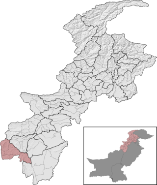
Dera Ismail Khan District, often abbreviated as D.I. Khan is a district in the Dera Ismail Khan division of the Khyber Pakhtunkhwa province of Pakistan. The capital of the district is the town of Dera Ismail Khan. The district has an area of 9,334 km2 (3,604 sq mi) and a population of 1,822,916 as of the 2023 Census. After the Second Anglo-Sikh war in 1849 the district was annexed by the British as part of the Punjab and remained so until 1901 when NWFP Khyber Pakhtunkhwa was created.

<span class="mw-page-title-main">Nowshera District</span> District of Khyber Pakhtunkhwa in Pakistan

Nowshera District is a district in the Peshawar Division of the Khyber Pakhtunkhwa province of Pakistan. The capital and district headquarter is Nowshera city.

<span class="mw-page-title-main">Karak District</span> District of Khyber Pakhtunkhwa in Pakistan

Karak District is a district in Kohat Division of Khyber Pakhtunkhwa province in Pakistan. It is situated to the south of Kohat District and on the north side of Bannu and Lakki Marwat districts on the main Indus Highway between Peshawar and Karachi – it is 131 km from the provincial capital Peshawar. It gained a district status in 1982, prior to which it was part of Kohat District.

<span class="mw-page-title-main">North Waziristan District</span> District in Khyber Pakhtunkhwa, Pakistan

North Waziristan District is a district of Khyber Pakhtunkhwa province in Pakistan. It is the northern part of Waziristan, a mountainous region of northwest Pakistan, bordering Afghanistan and covering 4,707 square kilometres (1,817 sq mi). The capital city of North Waziristan is Miranshah.

<span class="mw-page-title-main">Lakki Marwat</span> Pakistani town

Lakki Marwat or Lakki is the headquarters of Lakki Marwat District in Khyber Pakhtunkhwa province of Pakistan. Lakki Marwat has become one of the fastest growing cities in Khyber Pakhtunkhwa. Lakki Marwat is also the 20th most populous city in the province of Khyber Pakhtunkhwa.

<span class="mw-page-title-main">Orakzai District</span> District of Khyber Pakhtunkhwa in Pakistan

Orakzai District is a district in the Kohat Division of the Khyber Pakhtunkhwa province of Pakistan. Before 1973, it was part of FR Kohat. Up until 2018, it was an agency within the erstwhile Federally Administered Tribal Areas. However, with the merger of the FATA with Khyber Pakhtunkhwa, it attained the status of a district.

<span class="mw-page-title-main">Hangu District, Pakistan</span> District in Khyber Pakhtunkhwa, Pakistan

Hangu District is a district within the Kohat Division of the Khyber Pakhtunkhwa. The district takes its name from the town of Hangu, which is its administrative centre. The name Hangu may also sometimes be applied to the Miranzai Valley which is partly within the district, bordering the Samana Range.

The Shirani, also spelled Sherani, are a Pashtun tribe, from the Sarbani tribal confederacy, who live in Afghanistan and Pakistan. The Sherani are mostly settled in the Frontier Region Dera Ismail Khan, in the Federally Administered Tribal Areas of Pakistan and in the adjoining Sherani District of Balochistan, Pakistan. Some clans have settled in other surrounding districts of Balochistan; and in the Zabul, Ghazni, and Kandahar provinces of Afghanistan.

<span class="mw-page-title-main">Dera Ghazi Khan District</span> Pakistani administrativ unit

Dera Ghazi Khan is a district in Punjab, Pakistan. Its administrative capital is Dera Ghazi Khan.

<span class="mw-page-title-main">Lakki Marwat District</span> District in Pakistan

Lakki Marwat is a district in the Bannu Division of the Khyber Pakhtunkhwa province of Pakistan. It was created as an administrative district on July 1, 1992, prior to which it was a tehsil of Bannu District.

<span class="mw-page-title-main">Swabi District</span> District of Khyber Pakhtunkhwa in Pakistan

Swabi District is a district in the Mardan Division of the Khyber Pakhtunkhwa province in Pakistan. It lies between the Indus and Kabul Rivers. Before becoming a district in 1988, it was a tehsil within the Mardan District. 96% of the population speaks Pashto as their first language.

<span class="mw-page-title-main">South Waziristan District</span> District of Khyber Pakhtunkhwa in Pakistan

South Waziristan District was a district in the Dera Ismail Khan Division of the Khyber Pakhtunkhwa province of Pakistan, before splitting into the Lower South Waziristan District and the Upper South Waziristan District on 13 April 2022. It covers around 11,585 km2 (4,473 mi2). Waziristan is located in the southwest of Khyber Pakhtunkhwa. It is situated between two rivers, the Tochi River to the north and the Gomal River to the south. The region was an independent tribal territory from 1893, separated from both Afghanistan and the British-ruled empire in the subcontinent. Raiding the tribal areas was a constant problem for the British, requiring frequent punitive expeditions between 1860 and 1945. Troops of the British Raj coined a name for this region "Hell's Door Knocker" in recognition of the fearsome reputation of the local fighters and inhospitable terrain. The district headquarter of the South Waziristan district is Wanna. South Waziristan is divided into three administrative subdivisions of Ladha, Sarwakai, and Wanna. These three subdivisions are further divided into eight Tehsils: Ladha, Makin, Sararogha, Sarwakai, Tiarza, Wanna, Barmal, and Toi Khula.

<span class="mw-page-title-main">Kohat District</span> Administrative sub-division in Pakistan

Kohat District is a district in the Kohat Division of the Khyber Pakhtunkhwa province of Pakistan. Kohat city is its district capital.

Isakhel Tehsil, is an administrative subdivision (tehsil) of Mianwali District in the Punjab province of Pakistan. The city of Isakhel is the headquarters of the tehsil which is administratively subdivided into 3 Municipal Committees 13 Union Councils. It is located between 32° 30′ and 33° 14′ N. and 71° 7′ and 71° 44′ E., with an area of 678 square miles (1,760 km2) and contains the towns of Isakhel, Kammar Mushani and Kalabagh

Tank is a tehsil located in Tank District, Khyber Pakhtunkhwa, Pakistan.

<span class="mw-page-title-main">Upper South Waziristan District</span> District of Khyber Pakhtunkhwa in Pakistan

Upper South Waziristan District is a district located in the Dera Ismail Khan Division of the Khyber Pakhtunkhwa province of Pakistan. The Upper South Waziristan District was established on 13 April 2022 when the South Waziristan District was bifurcated into Lower South Waziristan and Upper South Waziristan. Spinkai ragzai region was declared as its capital.

<span class="mw-page-title-main">Lower South Waziristan District</span> District of Khyber Pakhtunkhwa in Pakistan

Lower South Waziristan District is adistrict located in the Dera Ismail Khan Division of the Khyber Pakhtunkhwa province of Pakistan. The Lower South Waziristan District was created in April 2022 after the South Waziristan District was bifurcated into Lower South Waziristan and Upper South Waziristan. Wana city serves as its capital and district headquarters.

References

  1. 1 2 "7th Population and Housing Census - Detailed Results: Table 1" (PDF). www.pbscensus.gov.pk. Pakistan Bureau of Statistics.
  2. 1998 District Census report of Tank. Census publication. Vol. 84. Islamabad: Population Census Organization, Statistics Division, Government of Pakistan. 2000.
  3. Tank: Crossroad to the Frontier Tribes
  4. "Constituencies and MPAs". Provincial Assembly of Khyber Pakhtunkhwa website. Archived from the original on 27 March 2008. Retrieved 26 October 2023.
  5. "Population by administrative units 1951-1998" (PDF). Pakistan Bureau of Statistics, Government of Pakistan website.
  6. "CENSUS OF INDIA, 1941 VOLUME X NORTH-WEST FRONTIER PROVINCE" . Retrieved 14 October 2021.
  7. "Pakistan Census 2017 District-Wise Tables: Charsadda". Pakistan Bureau of Statistics .
  8. "Pakistan Census 2023" (PDF). www.pbscensus.gov.pk. Pakistan Bureau of Statistics.
  9. 1 2 "7th Population and Housing Census - Detailed Results: Table 11" (PDF). Pakistan Bureau of Statistics .

Chisholm, Hugh, ed. (1911). "Tonk"  . Encyclopædia Britannica . Vol. 27 (11th ed.). Cambridge University Press. p. 10.

  1. Tank tehsil of erstwhile Dera Ismail Khan district, which roughly corresponds to the present district excluding the former Frontier Region Tank. District and tehsil borders have shifted since 1941.
  2. Different from official population figure since it excludes sensitive areas where religion was not asked

32°07′48″N70°13′48″E / 32.1300°N 70.2300°E / 32.1300; 70.2300