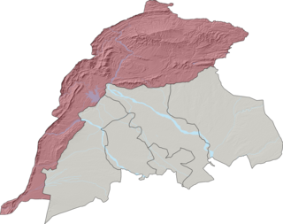
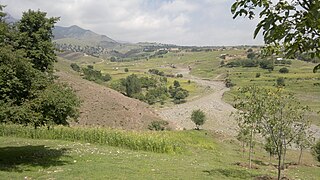
Waziristan is a mountainous region of Pakistani province of Khyber Pakhtunkhwa. The Waziristan region administratively splits among three districts: North Waziristan, Lower South Waziristan District, and Upper South Waziristan District. Waziristan region, consisted of three districts, covers around 11,585 square kilometres (4,500 sq mi) and is mainly populated by the Mehsud, The Wolves, & Wazir Pashtun tribe, who speak the Waziri dialect of the Pashto language.

Bannu District is a district in the Bannu Division of the Khyber Pakhtunkhwa province of Pakistan. Its status as a district was formally recorded in 1861 during the British Raj.

Orakzai District is a district in the Kohat Division of the Khyber Pakhtunkhwa province of Pakistan. Before 1973, it was part of FR Kohat. Up until 2018, it was an agency within the erstwhile Federally Administered Tribal Areas. However, with the merger of the FATA with Khyber Pakhtunkhwa, it attained the status of a district.

South Waziristan District was a district in the Dera Ismail Khan Division of the Khyber Pakhtunkhwa province of Pakistan, before splitting into the Lower South Waziristan District and the Upper South Waziristan District on 13 April 2022. It covers around 11,585 km2 (4,473 mi2). Waziristan is located in the southwest of Khyber Pakhtunkhwa. It is situated between two rivers, the Tochi River to the north and the Gomal River to the south. The region was an independent tribal territory from 1893, separated from both Afghanistan and the British-ruled empire in the subcontinent. Raiding the tribal areas was a constant problem for the British, requiring frequent punitive expeditions between 1860 and 1945. Troops of the British Raj coined a name for this region "Hell's Door Knocker" in recognition of the fearsome reputation of the local fighters and inhospitable terrain. The district headquarter of the South Waziristan district is Wanna. South Waziristan is divided into three administrative subdivisions of Ladha, Sarwakai, and Wanna. These three subdivisions are further divided into eight Tehsils: Ladha, Makin, Sararogha, Sarwakai, Tiarza, Wanna, Barmal, and Toi Khula.
Mīrānshāh (Pashto: میران شاه) is a small town that is the administrative headquarters of North Waziristan District, Khyber Pakhtunkhwa province of Pakistan. Miranshah lies on the banks of the Tochi River in a wide valley surrounded by the foothills of the Hindu Kush mountains. It is located at an elevation of about 930 metres (3,050 ft), 17 kilometres (11 mi) from the Pakistan-Afghanistan border. The nearest city in Pakistan is Bannu, about 55 kilometres (34 mi) to the east, while the nearest city across the border in Afghanistan is Khost, 60 kilometres (37 mi) to the northwest.

Khyber District is a district in the Peshawar Division of the Khyber Pakhtunkhwa province of Pakistan. Until 2018, it was an agency of the erstwhile Federally Administered Tribal Areas. With the merger of FATA with Khyber Pakhtunkhwa in 2018, it became a district. It ranges from the Tirah valley down to Peshawar. It borders Nangarhar Province to the west, Orakzai District to the south, Kurram District to southwest, Peshawar to the east and Mohmand District to the north.

Mohmand District is a district in Peshawar Division of Khyber Pakhtunkhwa province in Pakistan. Until 2018, it was an agency of Federally Administered Tribal Areas, with merger of FATA with Khyber Pakhtunkhwa, it became a district. It was created as an agency in 1951. Mohmand is bordered by Bajaur District to the north, Khyber District to the south, Malakand and Charsadda districts to the east and Peshawar district to the southeast.

Bannu Division is one of seven divisions in Pakistan's Khyber Pakhtunkhwa province. It consists of three districts: Bannu, Lakki Marwat, and North Waziristan. The division borders Dera Ismail Khan Division to the south and west, Kohat Division to the north and east, and the province of Punjab, Pakistan to its east. CNIC code of Bannu Division is 11.

Mir Ali or Mirali is a town in North Waziristan District, in Pakistan's Khyber Pakhtunkhwa province. Mirali is located in the Tochi Valley, about 12 kilometres (7.5 mi) east of Miramshah, 40 kilometres (25 mi) west of Bannu, Khyber Pakhtunkhwa, and 70 kilometres (43 mi) southeast of the city of Khost, Afghanistan. Mirali is at an altitude of 674 metres (2,211 ft).

Razmak is one of the three subdivisions of North Waziristan District in Pakistan, the other two being Mir Ali and Miran Shah. The inhabitants are almost exclusively Wazir Pashtuns, along with a few from the Mahsud tribe. The town of Razmak is located just north of Makeen, South Waziristan.

Wazir Tehsil is an administrative subdivision (tehsil) of Bannu District, Bannu Division, Khyber Pakhtunkhwa Province, Pakistan. The total population, according to the 1998 census, was 19,600, 98.1% of which have Pashto as a first language, and the remaining 1.9% speak Punjabi.

Bettani Tehsil is an administrative subdivision (tehsil) of Lakki Marwat District in Khyber Pakhtunkhwa province of Pakistan. This subdivision shares its boundary on the north with Bannu Subdivision, on the west with Jandola Tehsil, to the west with North and South Waziristan and to the northeast with the district of Lakki Marwat. Its total area is 132 square kilometers.

The Federally Administered Tribal Areas, commonly known as FATA, was a semi-autonomous tribal region in north-western Pakistan that existed from 1947 until being merged with the neighbouring province of Khyber Pakhtunkhwa in 2018 through the Twenty-fifth amendment to the constitution of Pakistan. It consisted of seven tribal agencies (districts) and six frontier regions, and were directly governed by the federal government through a special set of laws called the Frontier Crimes Regulations.

Datakhel or Datta Khel is a town in North Waziristan district of Khyber Pakhtunkhwa, Pakistan.

Eidak is a village in North Waziristan, Pakistan, 50 kilometres to the east of Bannu, lying close to the border with Afghanistan. Its inhabitants are mainly Pashtun-speaking Dawaris.
Wana Tehsil is a subdivision located in Lower South Waziristan District District, Khyber Pakhtunkhwa, Pakistan. The population is 152,881 according to the 2017 census.
Gharyum Tehsil is a subdivision located in North Waziristan district, Khyber Pakhtunkhwa, Pakistan. The population is 11,780 according to the 2017 census.
Miran Shah Tehsil is a subdivision located in North Waziristan District, Khyber Pakhtunkhwa, Pakistan. The population is 100,680 according to the 2017 census.

Razmak Tehsil is a subdivision located in North Waziristan district, Khyber Pakhtunkhwa, Pakistan. The population is 17,629 according to the 2017 census.


