
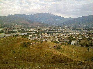
Nowshera District is a district in the Peshawar Division of the Khyber Pakhtunkhwa province of Pakistan. The capital and district headquarter is Nowshera city.
The Kundi (Niazi) (Pashto: کُنډی; Urdu: کُنڈی) is a sub-tribe of the Niazi tribe of Pashtuns, Afghan that inhabit most areas of Tank Mianwali and D.I.Khan. Niazi is the Largest Afghan/ Pashtun Tribe which has many Clans like Michen khel, Kundi etc..

Lakki Marwat is a district in the Bannu Division of the Khyber Pakhtunkhwa province of Pakistan. It was created as an administrative district on 1 July 1992, prior to which it was a tehsil of Bannu District.
Lower Dir District is a district in the Khyber Pakhtunkhwa province of Pakistan. Timergara is the district's headquarters and largest city. The Lower Dir district was formed in 1996, when Dir District was divided into Upper Dir and Lower Dir districts. On 22 January 2023, both Lower Dir and Upper Dir districts were further bifurcated to create a new Central Dir District. Lower Dir is famous for its beautiful snow-capped mountains, valleys, and pleasant weather. The primary industry in Lower Dir is tourism, which is now rapidly growing.

Swabi District is a district in the Mardan Division of the Khyber Pakhtunkhwa province in Pakistan. It lies between the Indus and Kabul Rivers. Before becoming a district in 1988, it was a tehsil within the Mardan District. 96% of the population speaks Pashto as their first language.

Khyber District is a district in the Peshawar Division of the Khyber Pakhtunkhwa province of Pakistan. Until 2018, it was an agency of the erstwhile Federally Administered Tribal Areas. With the merger of FATA with Khyber Pakhtunkhwa in 2018, it became a district. It ranges from the Tirah valley down to Peshawar. It borders Nangarhar Province to the west, Orakzai District to the south, Kurram District to southwest, Peshawar to the east and Mohmand District to the north.

Tank District is a district in the Dera Ismail Khan Division of the Khyber Pakhtunkhwa province of Pakistan.

Dera Ismail Khan Division is an administrative division of Khyber Pakhtunkhwa Province, Pakistan. It is the southernmost division of Khyber Pakhtunkhwa. CNIC code of Dera Ismail Khan Division is 12.
Tangi is a Tehsil and union council of Charsadda District in the Khyber Pakhtunkhwa province of Pakistan.
Battagram Tehsil is an administrative subdivision (Tehsil) of the Battagram District in the Khyber Pakhtunkhwa province of Pakistan. It serves as the Tehsil headquarters and covers a total area of 300 square miles (780 km2). Battagram Tehsil merged into Pakistan as an administrative region before being raised to the status of a district in 1993. On October 8, 2005, a 7.6 magnitude earthquake in Kashmir badly affected the area.

Drazanda Tehsil is an administrative subdivision (tehsil) of Dera Ismail Khan District in Khyber Pakhtunkhwa province of Pakistan. It borders South Waziristan to the north, Dera Ghazi Khan and Musa Khel to the south and Zhob to the west. The capital is the town of Drazanda.

Jandola Tehsil is an administrative subdivision (tehsil) of Tank District in Khyber Pakhtunkhwa province of Pakistan. The subdivision borders South Waziristan to the north, south and west and Lakki Marwat District to the north-east.

Datakhel or Datta Khel is a town in North Waziristan district of Khyber Pakhtunkhwa, Pakistan.
Gul Imam is a village in Tank District of Khyber Pakhtunkhwa province in Pakistan. It is located around 15 km from Tank town in Tank district.
Lower Kohistan District is a district in the Hazara Division of the Khyber Pakhtunkhwa province of Pakistan. Pattan is the district headquarters of Lower Kohistan. Kohistani people form majority in the district.

Upper Kohistan District is a district in the Hazara Division of the Khyber Pakhtunkhwa province of Pakistan.
Shabqadar Tehsil is a tehsil in Charsadda District, Khyber Pakhtunkhwa, Pakistan. The tehsil is named after Shabqadar town, which is capital and tehsil headquarter.
Pabbi is a tehsil located in Nowshera District, Khyber-Pakhtunkhwa, Pakistan. The tehsil is named after the Pabbi town, which is located on the GT Road.
Jehangira Tehsil is a tehsil located in Nowshera District, Khyber-Pakhtunkhwa, Pakistan. The tehsil is named after the Jehangira town, which is located on the GT Road. A village, Hasan Darra, also exists in Tehsil Jehangira.

Barang Tehsil is an administrative subdivision (tehsil) of Bajaur District in Khyber Pakhtunkhwa, Pakistan. Barang is the sixth largest of Bajaur District's seven tehsils.
