Jalbai

Last updated
Jalbai
Village
2024-02-07 at 20.16.30 534ddb7a.jpg
Coordinates: 34°00′44″N72°16′08″E / 34.0121°N 72.2689°E / 34.0121; 72.2689
Country Flag of Pakistan.svg  Pakistan
Province PK-NWFP.svg  Khyber Pakhtunkhwa
Division Mardan
District Swabi
Tehsil Lahor
Area
  Total44.79 km2 (17.29 sq mi)
Elevation
317 m (1,040 ft)
Population
 (2017)
  Total37,479
  Density840/km2 (2,200/sq mi)
Demonym Jalbiwal
Time zone UTC+5:00 ( PST)
Postal Code
23600
Area code 0938
Language Pashto

Jalbai is a village of Lahor Tehsil in Swabi District of Khyber Pakhtunkhwa, Pakistan, with a population of over 40 thousand in the 2017 census. Jalbai is primarily populated by Pashtuns, who comprise the second-largest ethnic group in the country.

Contents

The main industry of the village is agriculture, including wheat and tobacco. The literacy rate is 85 percent.

Etymology

Jalbai is named after its position as "Jail B" during British Rule.

Geography

Topography

Jalbai is located in Tehsil Lahor of District Swabi, bordered by Tordher in south, Mardan District in north, Mian Eisa (Nowshera District) in west, Manki in east, Jalsai in northeast and Jehangira in southwest.

Climate

With an influence from the local steppe climate, Jalbai features a hot semi-arid climate (Köppen BSh), with very hot, prolonged summers and brief, mild to cool winters. Winter in Jalbai starts in November and ends in late March, though it sometimes extends into mid-April, while the summer months are from mid-May to mid-September. The mean maximum summer temperature surpasses 40 °C (104 °F) during the hottest month, and the mean minimum temperature is 25 °C (77 °F). The mean minimum temperature during the coolest month is 4 °C (39 °F), while the maximum is 18.3 °C (64.9 °F).

June is the hottest month of the year with an average temperature of 32.9 °C. January is the coldest month with an average temperature of 10.2 °C.

Demographics

Population

The population of Jalbai in 2017 was 37,479. The male population was 19,103 (50.96%), while the female population was 18,375 (49.02%). The literacy rate was 85%.

Language

The primary native language spoken in Jalbai is Pashto, while Urdu is the native minority language, though English is used in educational institutions, while Urdu is understood throughout the village – as the national language of the country.

Religion

The overwhelming majority of residents of Jalbai follows and professes the Sunni Islam.

Education

Numerous educational institutes — schools are located in Jalbai.

Following are some of the notable educational institutes:

Economy

Approximately 50% of the economy depends on agriculture.

Agriculture

Wheat, peanuts, maize, sugarcane and tobacco play an important role in Jalbai's economy by generating income and employment in farming. Jalbai is also famous for Guava fruit.

Guava of Jalbai Guava fruit jalbai.jpg
Guava of Jalbai
tobacco farm at Jalbai Tobacco farm at Jalbai.jpg
tobacco farm at Jalbai

Mining

Sand mining is a significant source of income and employment for a substantial number of people in Jalbai.

Sand Mining at Jalbai Sand Mining at Jalbai.jpg
Sand Mining at Jalbai

Transportation

Road

Jalbai main road that connects Jalbai to Tordher, while the M-1 Motorway provides an alternate route to Peshawar and Islamabad. The Jalbai Mera Lar also provides access to the Swat Motorway also known as the M-16 or Swat Expressway.

Jalbai Main Road (Tordher to Jalbai) Jalbai main rd.jpg
Jalbai Main Road (Tordher to Jalbai)
Jalbai Main Road (Jalbai to Tordher) Jalbai main road.jpg
Jalbai Main Road (Jalbai to Tordher)

Motorways

Jalbai is connected to Islamabad and Peshawar by the 155 kilometer long M-1 Motorway. The motorway also links Jalbai to major cities in the province, such as Charsadda and Mardan. The M-1 motorway continues onwards to Lahore as part of the M-2 motorway.

Interchange connecting near Jalbai on M1 that intersects M1 with the origin of M16 heading towards Swat valley, also known as Karnal Sher Khan Interchange.

Administration

The village of Jalbai contains three Union Councils, Jalbai Mera and Jalbai (East and West); each Union is administered by its own nazim.

Landmarks

Jalbai Rest House – a well known place, and travel destination.

Bhai Masjid Jalbai – village's old mosque

Sports

Cricket is the most popular sport in Jalbai with School Ground Jalbai is the main ground. There is also small cricket and football grounds.

School Ground Jalbai School Ground Jalbai - December 2022.jpg
School Ground Jalbai
School Ground Jalbai Swabi School ground jalbai swabi.jpg
School Ground Jalbai Swabi

Cuisine

Rice dishes and kebabs feature prominently in cuisine. Meat is eaten more often in cuisine than any other cuisines. Kabuli palaw, Bannu Pulao, Chapli kabab, tika, and mutton karahi are the most famous dishes of the region.

Biryani with Tikka.jpg

Related Research Articles

<span class="mw-page-title-main">Mardan District</span> District in Khyber Pakhtunkhwa, Pakistan

Mardan District is a district in the Mardan Division of the Khyber Pakhtunkhwa province of Pakistan. The district is named after Mardan city, which is also the headquarters of the district. The district is famous for its agriculture industry and its archaeological sites, specifically of Takht-i-Bhai, Jamal Garhi and Sawal Dher.

<span class="mw-page-title-main">Nowshera District</span> District of Khyber Pakhtunkhwa in Pakistan

Nowshera District is a district in the Peshawar Division of the Khyber Pakhtunkhwa province of Pakistan. The capital and district headquarter is Nowshera city.

<span class="mw-page-title-main">Swabi</span> City in Khyber Pakhtunkhwa, Pakistan

Swabi is a city in the Khyber Pakhtunkhwa province of Pakistan. It is located near the bank of the Indus River. It is the 73rd largest city of Pakistan and eighth largest in the province in Khyber Pakhtunkhwa. Swabi is also a major city in the Mardan Division, where it is the second-largest city.

<span class="mw-page-title-main">Karnal Sher Khan</span> Nishan-e-Haider, Capt Pakistan Army

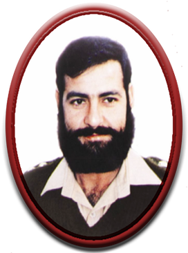
Karnal Sher Khan was a Pakistani military officer. He is one of only eleven recipients of Pakistan's highest military gallantry award, Nishan-e-Haider. He was a captain in the 27th Sindh Regiment of the Pakistan Army and later was posted to 12th NLI Regiment during the Kargil War. He was killed in action during the war. For his bravery during the Kargil War, he was awarded the Nishan-e-Haider. His name is the localised form of the rank Colonel.

<span class="mw-page-title-main">Nowshera, Khyber Pakhtunkhwa</span> City in Khyber Pakhtunkhwa, Pakistan

Nowshera is the capital city of Nowshera District in the Khyber Pakhtunkhwa province of Pakistan. It is the 78th largest city in Pakistan and ninth largest city in the province of Khyber Pakhtunkhwa.

<span class="mw-page-title-main">Swabi District</span> District of Khyber Pakhtunkhwa in Pakistan

Swabi District is a district in the Mardan Division of the Khyber Pakhtunkhwa province in Pakistan. It lies between the Indus and Kabul Rivers. Before becoming a district in 1988, it was a tehsil within the Mardan District. 96% of the population speaks Pashto as their first language.

<span class="mw-page-title-main">Mardan Division</span> Division in Khyber Pakhtunkhwa, Pakistan

Mardan Division is one of the seven divisions in the Khyber Pakhtunkhwa province of Pakistan. It consists of two districts: Mardan and Swabi. According to the 2017 Pakistani Census, the division had a population of 3,997,667, making it the fourth-most populous division in the province. However, it only spans 3,175 km2 (1,226 sq mi) of area, which makes it the smallest division by area in the province as well. Mardan, with over 350,000 people, is the division's namesake and most populous city. The division borders Hazara Division, Malakand Division, and Peshawar Division. CNIC code of Mardan Division is 16.

Sawal Dher is an historic village in Mardan District of Khyber Pakhtunkhwa, Pakistan, that contains the remains of an ancient city. The village is located 10 kilometers southwest of Katlang-Jamal Ghari, most of the relics of this site are now in Museum. This site is situated at a distance of 4 kilometers in the southwest of Jamal Garhi. Most of the sculptures of this monastery are preserved in Peshawar and Lahore Museums. It is 19 km away from the district capital Mardan.

Lāhor (لاهور), also known as Little Lahore, previously known as Salatura (سلاطوره), is a town within the Swabi District of Khyber Pakhtunkhwa, Pakistan. The town serves as the headquarters of the Lahor Tehsil and is administratively subdivided into two union councils. The town is a settlement of 35,000 people and is located at 34°02′54″N72°21′56″E with an altitude of 308 metres and lies west of Swabi and on the northern bank of the Indus River. In the vicinity of Lahor are Panjpir, Hund and Zaida three other cities of the ancient world.

Rashakai is a small town located along the Nowshera-Mardan road, in Khyber-Pakhtunkhwa.

<span class="mw-page-title-main">Panjpir</span> Union Council in Khyber-Pakhtunkhwa, Pakistan

Panjpir is a town and Union council of Swabi District in the Khyber Pakhtunkhwa province of Pakistan that is surrounded by Shahmansoor, Kaddi, Thand Kohi, Bam Khel, Darra and Ismailabad.Panj peer means five Sufi Sanits. District Swabi has 4 Tehsils i.e. Swabi Tehsil, Lahor, Topi Tehsil and Razar. Each Tehsil comprises certain numbers of union councils. There are 56 union councils in district Swabi.

Jehangira is a town in the Khyber-Pakhtunkhwa province of Pakistan.

Ismaila is a town and Union Council of Swabi District in the Khyber-Pakhtunkhwa province of Pakistan. It is located at 34°13'0N 72°15'0E

<span class="mw-page-title-main">Maini</span> Village in Khyber Pakhtunkhwa, Pakistan

Maini is the name of a village and a union council as well as a lush green physiographic valley with natural streams and fertile agricultural land which resides in Topi Tehsil in the eastern part of Swabi District of the province of Khyber Pakhtunkhwa in Pakistan. It has a very detailed historic profile, from the early historic age till the Partition of Pakistan. Maini lies at latitude 34°07'07.23" north and longitude 72°36'32.38" east with an elevation of about 383 meters above the sea level. Total area of Maini valley is about 5 kilometres from east to west and 6 kilometres from north to south.

<span class="mw-page-title-main">Ranigat</span> Buddhist ruins

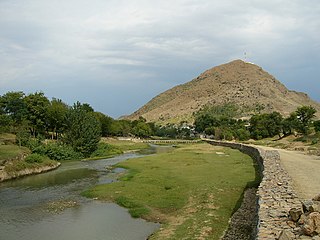
Ranigat is a collection of 2nd-century CE Buddhist ruins spread over an area of 4 square kilometers that dates from the Gandhara civilization. Ranigat is located in the Buner Valley of Pakistan's Khyber Pakhtunkhwa province.

Mehr Ali is a village located in Razar Tehsil, Swabi District in the Pakistani province of Khyber Pakhtunkhwa. The road from Shewa Adda leading to Sher Darra passes through Mehr Ali. The road ends at Sher Darra, a village about three kilometres at the north of Mehr Ali from where the Buner District starts. It is surrounded by Barsati Nalahs from the east and west. There are two roads; one of them leads from Rustam via Machi Mardan District, and another from Mehr Ali links to another road that leads to Swat valley. It lies at the foot of the Himalayan range of mountains.

<span class="mw-page-title-main">M-16 motorway (Pakistan)</span> Motorway in Pakistan

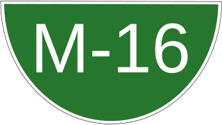
The Swat Motorway(Urdu: سوات موٹر وے, Pashto: سوات بزرگراه ), also known as the M-16 or Swat Expressway, is a 160-kilometre-long (99 mi) four-lane motorway and provincial controlled-access highway in the Khyber Pakhtunkhwa province of Pakistan. Phase-1 of the project, completed in June 2019, connects the existing M-1 motorway at Nowshera to Chakdara while the under-construction second phase will extend the project to Fatehpur.

<span class="mw-page-title-main">Darra, Swabi</span> Village Council in Swabi, Pakistan

Darra is a village and village council located in Tehsil and District Swabi, in the Khyber Pakhtunkhwa province of Pakistan.

References

34°00′51″N72°16′05″E / 34.0142°N 72.2681°E / 34.0142; 72.2681