Upper Swat District | |
|---|---|
| Nickname: Switzerland of Pakistan [1] | |
Interactive map of Upper Swat District | |
| Coordinates: 35°12′N72°29′E / 35.200°N 72.483°E | |
| Country | |
| Province | |
| Division | Malakand |
| Established | 20 December 2025 |
| Capital | Matta, Swat |
| Largest city | Matta, Swat |
| Number of Tehsils | 3 |
| Government | |
| • Type | District Administration |
| Area | |
• Total | 3,975 km2 (1,535 sq mi) |
| Population | |
• Total | 1,130,354 |
| • Density | 284.4/km2 (736.5/sq mi) |
| Literacy | |
| Time zone | UTC+5 (PKT) |
| Website | swat |
Upper Swat District is a newly created district in Khyber Pakhtunkhwa, Pakistan. It was carved out of the Swat District in October 2025. [3] It consists of the Behrain, Matta and Khwazakhela Tehsils of former Swat District, with Matta as headquarters. [4] [5]
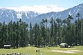
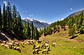
With lush forests, verdant alpine meadows, and snow-capped mountains, Upper Swat is one of the country's most popular tourist destinations. [6] [7]
Upper Swat District is centered around Swat Kohistan. Swat Kohistan forms the larger, northern part of the district, and is mainly inhabited by the indigenous Kohistani, Torwali and Kalami peoples. The lower parts forms the lower portion of the district and has a Pashtun majority, with a significant Gujar population. [5] In terms of administrative divisions, Swat is surrounded by Lower Chitral and Upper Dir to the west, Gilgit-Baltistan to the north, and Kohistan and Shangla to the east and southeast, respectively.
The Swat Valley is enclosed by mountains that forms a natural geographic boundary for it. The Swat River whose headwaters arise in the 5,500-to-5,800-metre-tall (18,000–19,000 ft) Hindu Kush mountain range runs through the length of the region. The main area consists of many sub valleys such as Kalam, Bahrain, Matiltan, Utror, and Gabral.
In August 2025, the Khyber Pakhtunkhwa government announced the plan to divide the Swat district. A notification was issued by the Revenue Department directing the Commissioners of Malakand Division and the Deputy Commissioner of Swat to submit a report on the division plan within three days. [8] [9]
On 19 December the provincial cabinet approved the bifurcation of the district and the creation of Upper Swat District, with Matta as the headquarters. [4]
Upper Swat District is mostly inhabited by Pashto speaking communities who make up 83.27% of the population. [10] Languages classified as 'Others', mainly Gawri and Torwali, are spoken by 13.48% of the population, and form the majority in the Swat Kohistan region of Upper Swat. [10]
Upper Swat is subdivided into three administrative units, known as Tehsils:
| Tehsil | Area (km2) [11] | Pop. (2023) | Density (ppl/km2) (2023) | Literacy rate (2023) [12] | Union Councils |
|---|---|---|---|---|---|
| Behrain Tehsil | 2,899 | 270,623 | 93.35 | 39.26% | |
| Matta Tehsil | 684 | 552,431 | 807.65 | 42.54% | |
| Khwaza Khela Tehsil | 392 | 307,300 | 783.93 | 42.63% |
Each tehsil comprises certain numbers of union councils.