1303 Hongdong earthquake

Last updated
1303 Hongdong earthquake
China edcp relief location map.jpg
Bullseye1.png
Local dateSeptember 25, 1303 (1303-09-25)
MagnitudeMw 7.2–7.6 [1]
Epicenter 36°48′N111°42′E / 36.8°N 111.7°E / 36.8; 111.7 [2]
Max. intensity MMI XI (Extreme) [2]
Casualties270,000 [2]
Map of the Shanxi Rift System along the eastern margin of the Ordos Block Ordos Block.png
Map of the Shanxi Rift System along the eastern margin of the Ordos Block

The 1303 Hongdong earthquake occurred in Yuan dynasty of the Mongol Empire, on September 25. The shock was estimated to have a moment magnitude of 7.6 and it had a maximum Mercalli intensity of XI (Extreme). This was one of the most deadly earthquakes in China, in turn making it one of the top disasters in China by death toll.

Contents

Geology

In 2018, the epicentre was revised to be at 36°48′N111°42′E / 36.8°N 111.7°E / 36.8; 111.7 in what is now Xiamenzhen, to the southwest of the seat of Lingshi County, Shanxi. [2] The epicentre had previously been determined to be 60 km south, in what is now Hongdong County. [2] The earthquake likely occurred on the Taigu fault zone in Shanxi, part of the Shanxi Rift System, and several scarps and uplifts of local faults were seen as evidence of this. The Taigu fault zone has not experienced any measurable activity since the 1303 earthquake. [3] The magnitude was calculated by modern seismologists to be 8.0 on the moment magnitude scale, though it is impossible to say for sure due to lack of accurate geological data. [3] [4]

Damage and casualties

This was one of the deadliest earthquakes in China, in turn making it one of the top disasters in China by death toll.

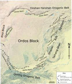
In the nearby towns of Zhaocheng and Hongdong, every major temple and school building collapsed and over half the towns' populations perished. Every building in Huo county, Shanxi was destroyed. [5] In Taiyuan and Pingyang, nearly 100,000 houses collapsed and over 200,000 people died from collapsing buildings and loess caves in a similar manner to the situation that would be experienced 253 years later in the 1556 Shaanxi earthquake. Cracks in the ground turned into miniature rivers, and many canals in Shanxi Province were destroyed, along with city walls. Some reports stated that the earthquake even levelled mountains and hills, altering the topographic make-up of the region. [5] Landslides and soil subsidence and liquefaction triggered by the shaking were a likely root cause of these large-scale environmental changes. [4] Rebuilding was generally slow, owing to the destroyed infrastructure of Shanxi and was interrupted by several other earthquakes in the following years. [5]

The 1303 Hongdong earthquake, though currently the last to have occurred on its fault system, marked the start of a centuries-long episode of heightened earthquake activity throughout China, [4] the first of several to occur up to the end of the twentieth century. It was also the first of many examples of earthquakes that demonstrated the tendency of earthquakes in China to strike near loess plateaus.

See also

Related Research Articles

<span class="mw-page-title-main">1976 Tangshan earthquake</span> Mw 7.6 earthquake in Hebei, China

The 1976 Tangshan earthquake was a Mw 7.6 earthquake that hit the region around Tangshan, Hebei, China, at 3:42 a.m. on 28 July 1976. The maximum intensity of the earthquake was XI (Extreme) on the Mercalli scale. In minutes, 85 percent of the buildings in Tangshan collapsed or were rendered unusable, all services failed, and most of the highway and railway bridges collapsed or were seriously damaged. The official report claimed 242,769 deaths and 164,851 serious injuries in Tangshan, but when taken into account the missing, the injured who later died and the deaths in nearby Beijing and Tianjin, scholars accepted at least 300,000 died, making it the deadliest earthquake in recorded history and one of the worst disasters in China by death toll.

<span class="mw-page-title-main">1556 Shaanxi earthquake</span> Natural disaster in China

The 1556 Shaanxi earthquake, known in Chinese colloquially by its regnal year as the Jiajing Great Earthquake "嘉靖大地震" or officially by its epicenter as the Hua County Earthquake "华县地震", occurred in the early morning of 23 January 1556 in Huaxian, Shaanxi during the Ming dynasty.

<span class="mw-page-title-main">1920 Haiyuan earthquake</span> 1920 earthquake in central China

The 1920 Haiyuan earthquake occurred on December 16 in Haiyuan County, Ningxia Province, Republic of China at 19:05:53. It was also called the 1920 Gansu earthquake because Ningxia was a part of Gansu Province when the earthquake occurred. It caused destruction in the Lijunbu-Haiyuan-Ganyanchi area and was assigned the maximum intensity on the Mercalli intensity scale. About 258,707-273,407 died, making it one of the deadliest earthquakes in China and disasters in China by death toll.

<span class="mw-page-title-main">1970 Tonghai earthquake</span> 1970 earthquake in southwest China and northern Vietnam

The 1970 Tonghai earthquake occurred at 01:00:41 local time on January 5 with a moment magnitude of 7.1 and a maximum Mercalli intensity of X (Extreme). The strike-slip rupture originated on the Red River Fault, which had not experienced an earthquake above magnitude 7 since 1700, and affected Tonghai County, Yunnan province, China. At least 10,000 people were killed, making it one of the deadliest in its decade. The tremor caused between US$5 and $25 million in damage, felt over an area of 8,781 km2 (3,390 sq mi). In Hanoi, North Vietnam, almost 483 km (300 mi) from the epicenter, victims left their homes as the rupture rumbled through the city.

The 1918 Shantou earthquake occurred in Shantou, Guangdong, Republic of China. Serious damage and high casualty numbers were reported in Guangdong and the surrounding provinces. It also caused some damage in British Hong Kong.

<span class="mw-page-title-main">1935 Shinchiku-Taichū earthquake</span> Earthquake in Taiwan

The 1935 Shinchiku-Taichū earthquake occurred with a Richter magnitude of 7.1 (7.1 Mw) in April 1935 with its epicenter in Taichung, Taiwan. It was the deadliest earthquake in Taiwan's recorded history, claiming 3,276 lives and causing extensive damage. Twelve seconds after the mainshock, an aftershock of ML 6.0 occurred, centered on Gabi Village.

A potent magnitude 6.6 Mw intraplate aftershock occurred at 17:16 JST (08:16 UTC) on 11 April, in the Hamadōri region of Fukushima, Japan. With a shallow focus of 13 km (8.1 mi), the earthquake was centred inland about 36 km (22 mi) west of Iwaki, causing widespread strong to locally severe shaking. It was one of many aftershocks to follow the 11 March Tōhoku earthquake, and the strongest to have its epicentre located inland.

<span class="mw-page-title-main">2013 Dingxi earthquakes</span> Very strong fatal earthquakes in Gansu province, China

On 22 July 2013, a series of earthquakes occurred in Dingxi, Gansu. The first quake struck at 07:45 China Standard Time with an epicenter located at the border of Min County and Zhang County. The magnitude of the initial earthquake was placed at Ms 6.6 by the China Earthquake Data Center with a focal depth of 20.0 kilometres (12 mi). It was measured at Mw 5.9 by the United States Geological Survey (USGS) and Mw  6.0 by the European Alert System. Another strong quake occurred about one hour later, measuring 5.6 magnitude by the USGS. As of 18:00 CST, 22 July 2013, 422 aftershocks had been recorded. The earthquakes were also felt in the nearby cities of Tianshui and Lanzhou in Gansu, as well as Xi'an, Baoji, and Xianyang in neighbouring Shaanxi.

<span class="mw-page-title-main">2014 Ludian earthquake</span> 6.1 magnitude earthquake in Yunnan, China

The 2014 Ludian earthquake struck Ludian County, Yunnan, China, with a moment magnitude of 6.1 on 3 August. The earthquake killed at least 615 people, injuring at least 2,400 others. At least 114 people remained missing. Over 12,000 houses collapsed and 30,000 were damaged. According to the United States Geological Survey, the earthquake occurred 29 km (18 mi) west-southwest of Zhaotong city at 16:30 local time (08:30 UTC).

<span class="mw-page-title-main">2016 Kumamoto earthquakes</span> Earthquake in Japan

The 2016 Kumamoto earthquakes were a series of earthquakes, including a magnitude 7.0 mainshock which struck at 01:25 JST on April 16, 2016 beneath Kumamoto City of Kumamoto Prefecture in Kyushu Region, Japan, at a depth of about 10 kilometres (6.2 mi), and a foreshock earthquake with a magnitude 6.2 at 21:26 JST (12:26 UTC) on April 14, 2016, at a depth of about 11 kilometres (6.8 mi).

The 1988 Lancang–Gengma earthquakes, also known as the 11.6 earthquakes by the Chinese media were a pair of devastating seismic events that struck Lancang and Gengma counties, Yunnan, near the border with Shan State, Burma. The earthquake measured moment magnitude (Mw ) 7.0 and was followed 13 minutes later by a 6.9 Mw  shock. These earthquakes were assigned a maximum China seismic intensity of IX and X, respectively. Between 748 and 939 people were killed; more than 7,700 were injured. Both earthquakes resulted in US$270 million in damage and economic losses. Moderately large aftershocks continued to rock the region, causing additional casualties and damage.

A major earthquake occurred during the rule of the Qing dynasty in Shandong Province on July 25, 1668. It had an estimated magnitude of Ms 8.5, making it the largest historical earthquake in East China, and one of the largest to occur on land. An estimated 43,000 to 50,000 people were killed, and its effects were widely felt. Its epicenter may have been located between Ju and Tancheng counties, northeast of the prefecture-level city of Linyi in southern Shandong.

The 1739 Yinchuan–Pingluo earthquake rocked the northern Ningxia Hui Autonomous Region on January 3 with an epicenter in the prefecture-level city Shizuishan. The estimated magnitude 7.1–7.6 earthquake had a maximum intensity of XI on the Mercalli intensity scale, and killed about 50,000 residents and officials. It was widely felt; perceived in Shanxi, Shaanxi and Hebei provinces. Aftershocks persisted for more than two years with the largest being a 5.5 on February 13 that same year.

The 2020 Qiaojia earthquake occurred in Yunnan, China, 42 km west of Zhaotong on May 18, 21:48 local time. The moment magnitude 5.1 quake occurred at a depth of 10 km. Various buildings were damaged, and one house collapsed in Zhaoyang District. Four people were killed while 24 people were injured.

<span class="mw-page-title-main">1695 Linfen earthquake</span> Earthquake in China

The 1695 Linfen earthquake struck Shanxi Province in North China, Qing dynasty on May 18. Occurring at a shallow depth within the continental crust, the surface-wave magnitude 7.8 earthquake had a maximum intensity of XI on the China seismic intensity scale and Mercalli intensity scale. This devastating earthquake affected over 120 counties across eight provinces of modern-day China. An estimated 52,600 people died in the earthquake, although the death toll may have been 176,365.

<span class="mw-page-title-main">1815 Pinglu earthquake</span> Earthquake in Shanxi, China

Western Henan and southern Shanxi in northern China were struck by an earthquake of estimated magnitude Ms6.8 on 23 October 1815. The epicentre was in Pinglu County in southernmost Shanxi, which was the worse affected area. It had a maximum felt intensity of IX (violent) on the Modified Mercalli scale. It caused the collapse of many houses and cave dwellings and led to the deaths of at least 13,000 people.

<span class="mw-page-title-main">1626 Lingqiu earthquake</span> 1626 earthquake in China

The 1626 Lingqiu earthquake had an epicentre in Lingqiu County, Shanxi Province during the Ming dynasty. The estimated surface wave magnitude (Ms ) 7.0 earthquake caused many buildings to collapse. Over 5,200 people were killed.

<span class="mw-page-title-main">Shanxi Rift System</span> Geological feature in China

The Shanxi Rift System or Fen–Wei Rift System is a zone of active extensional tectonics that forms the eastern margin of the Ordos Block in northern China. The zone extends for at least 900 km (560 mi) and runs south-southwest to north-northeast. The individual rift basins that make up the rift system have an overall en echelon geometry, consistent with a right lateral sense of strike-slip displacement across the zone. The basins contain a thick sedimentary sequence of Neogene age, which ranges from 2.0 to 3.8 km in thickness. The rift system is continuous with the Weihe Basin to the southwest, which became active during the Paleogene. Rupture of the major normal faults that bound the Weihe and Shanxi rift basins has caused many large and damaging historical earthquakes, including the 1303 Hongdong, 1556 Shaanxi, 1626 Lingqiu, 1695 Linfen and 1815 Pinglu events.

<span class="mw-page-title-main">2022 Luding earthquake</span> Earthquake in China

A Mw 6.7 earthquake struck Luding County in Sichuan province, China on 5 September 2022 at 12:52:19 local time. The epicenter was located 226 km (140 mi) from Chengdu, or 43 km (27 mi) southeast of Kangding. Ninety-three people died, 424 were injured and 24 remained missing. More than 13,000 homes and other infrastructure were damaged or destroyed. It was the largest earthquake to strike the province since 2017.

References

  1. Xu, Yueren; He, Honglin; Deng, Qidong; Allen, Mark B.; Sun, Haoyue; Bi, Lisi (2018), "The CE 1303 Hongdong Earthquake and the Huoshan Piedmont Fault, Shanxi Graben: Implications for Magnitude Limits of Normal Fault Earthquakes" (PDF), Journal of Geophysical Research: Solid Earth, 123 (4): 3098–3121, Bibcode:2018JGRB..123.3098X, doi:10.1002/2017JB014928, S2CID   135046043
  2. 1 2 3 4 5 徐岳仁; 何宏林; 李文巧; 张伟恒; 田勤俭 (2018). "1303 年洪洞地震宏观震中修订的新证据" [New evidences for amendment of macro-epicenter location of 1303AD Hongtong earthquake]. 地震地质. 40 (5): 948, 956, 960.
  3. 1 2 Xie, Xin-sheng; Jiang, Wa-li; Wang, Huan-zhen; Feng, Xi-ying (2004). "Holocene activities of the Taigu fault zone, Shanxi Province, and their relations with the 1303 Hongdong M=8 earthquake". Acta Seismologica Sinica. 17 (3): 308–321. Bibcode:2004AcSSn..17..308X. doi:10.1007/s11589-004-0053-x. S2CID   131656457.
  4. 1 2 3 Stein, Seth; Mazzotti, Stéphane (2007-01-01). Continental Intraplate Earthquakes: Science, Hazard, and Policy Issues. Geological Society of America. ISBN   9780813724256.
  5. 1 2 3 "Ruins of the Hongdong Earthquake(1303)". www.kepu.net.cn. Retrieved 2015-11-28.