Ordos Block

Last updated
Map of the Ordos Block showing the active fault systems that form its boundaries Ordos Block.png
Map of the Ordos Block showing the active fault systems that form its boundaries

The Ordos Block is a crustal block, that forms part of the larger North China Block (NCB). It is surrounded by active fault systems and has been a distinct block since at least the Mesozoic. It is bordered to the west by the Alxa Block, the westernmost part of the NCB, to the south by the Qinling orogenic belt, to the north by the Yanshan-Yinshan orogenic belt, part of the Central Asian Orogenic Belt and to the east by the Taihangshan mountain range, which forms part of the Trans-North China Orogen. [1] The block is currently stable and large earthquakes are restricted to the bordering fault zones. It has been suggested that the block is currently undergoing anti-clockwise rotation with respect to the Eurasian Plate, as a result of the ongoing eastward spreading of the Tibetan Plateau, [2] although this view has been challenged. [3]

Contents

Extent

The Ordos Block is a roughly rectangular fault-bounded part of the larger North China Block, which itself closely matches the extent of the Paleoproterozoic North China Craton. It covers an area of about 250,000 km2 and has a thick lithosphere of more than 200 km, suggesting that, unlike other parts of the NCB, it retains a fully cratonic character. [4]

Geology

The shallow geology of Ordos Block consists of a thick sequence of Phanerozoic sedimentary rocks in what is known as the Ordos Basin. There are three main sequences, of Lower Paleozoic, Upper Paleozoic and Mesozoic age. The Lower Paleozoic sequence consists of mainly carbonate rocks ranging from middle Cambrian to lower Ordovician in age. Following a regional unconformity associated with the Caledonian orogeny, sedimentation resumed during the Carboniferous and continued through the Permian with a sequence of clastic sedimentary rocks, including significant thicknesses of coal. The overlying Mesozoic sequence consist of mainly fluvial and lacustrine deposits. The youngest unit preserved in the basin is of Lower Cretaceous age, with any younger parts of the sequence having been eroded following uplift during the Neogene. [5] This erosion surface is covered in the southern part of the block by Upper Neogene to Quaternary deposits of red clay and loess, part of the Loess Plateau. [6]

The understanding of the deep geology of the Ordos Block is based on the interpretation of gravity and magnetic data, backed up by a limited amount of deep borehole samples, yielding geochronological and isotope data. On the basis of this dataset, the block appears to be divided into a northern and southern part with contrasting histories. They are juxtaposed across the northwest–southeast trending Datong-Huachi fault. The northern part consists mainly of partly migmatised metasedimentary rocks with granitic gneisses. They are partly of Neoarchean age, with reworking at several periods during the Paleoproterozoic. The southern part is thought be of Paleoarchean to Mesoarchean in age, with some Neoarchean additions. [7]
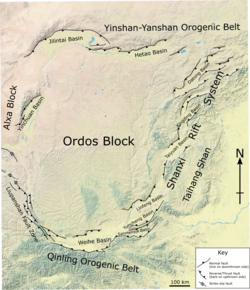
Margins

All the margins of the Ordos Block are tectonically active. The style of tectonics varies around the block, with reverse faulting at its southwestern corner along the Liupanshan Fault. Rifting to the northwest and north on the Yinchuan, Jilantai and Hetao Basins and rifting within a zone of distributed right lateral strike-slip along its eastern and southern margin, forming the Weihe-Shanxi Rift System. [2] [8]

Liupanshan Fault

This belt of NNW–SSE trending thrusting and reverse faulting runs for about 180 km and forms the southwestern margin of the Ordos Block. This thrust belt began to form during the Pliocene. The zone accommodates shortening associated with the eastward motion of the Tibetan Plateau at a rate of about 6 mm per year, although GPS data suggest that current motion across the thrust zone is only about a half of that. There is also a smaller component of right lateral shear along the zone. [2]

Yinchuan Basin

This ~160 km long SSW–NNE trending rift basin has a half-graben geometry. It has been active since at least the middle Oligocene and contains a thick sedimentary fill (>8 km). It has had a long tectonic history, starting with a phase of northwest–southeast directed extension from the Oligocene to the middle Miocene. This was followed by a short period of inversion related to NW–SE compression during the early part of the late Miocene, before a return to NW–SE extension for the rest of the Late Miocene into the Pliocene. From the Late Pleistocene to the present day, the basin has been in an overall transtensional regime affected by a combination of NE–SW compression and NW–SE extension. [8] A right lateral slip-rate of about 2 mm per year has been estimated across the basin, with about 1 mm per year of extension. [2]

Jilintai Basin

The Jilintai Basin is arcuate in shape, following the main bounding fault zone to the north, consisting of the Langshan Piedmont and Seertengshan faults. It has an overall half-graben geometry. It has a similar tectonic history to the neighbouring Yinchuan Basin. [8] A right lateral slip-rate of about 0.8 mm per year has been estimated, with about 1.6 mm per year of extension. [2]

Hetao Basin

This basin trends WSW–ENE and also has a half-graben geometry. The main bounding fault zone lies to the north of the basin and consists of the Wulashan, Daqingshan and Helinggeer faults. It shares the early history of the Yinchuan and Jilintai basins, but the recent tectonics in this case appear to be approximately north–south extension. [8] Estimated slip-rates are low, with high uncertainties, with small amounts of left-lateral strike-slip combined with a small component of either extension or shortening. [2]

Shanxi Rift System

This group of rift basins forms the SSW–NNE trending eastern margin of the Ordos Block, over a distance of >900 km. The individual basins and their bounding high-angle normal faults have a WSW–ENE to SW–NE trend. They have an overall en echelon geometry, consistent with right lateral sense of displacement over the zone. The age of the 2.0–3.8 km thick sedimentary sequences in the basins indicates that they became active during the Miocene to Pliocene. [8] GPS-derived slip rates on the various basins in the rift system show consistent small amounts of right lateral strike-slip combined with generally smaller amounts of extension. [2]

Weihe Basin

The Weihe Basin forms the southern margin of the Ordos Block. It is regarded as part of the Shanxi Rift System by some geologists [9] and as a distinct rift element by others. [8] [2]

The basin which has a sedimentary fill of 4 km to 6 km in thickness, consists of several sub-basins with a half-graben geometry, controlled by major normal faults. The basins started to form in the Eocene as a result of NW–SE extension. After a brief period of NE–SW extension in the Pleistocene, the current tectonic setting began, which consists of NNW–SSE extension. This ongoing extension has been responsible for large historical damaging earthquakes, such as those in 1556 and 1815. [8] GPS data are unable to constrain the current displacement rates. [2]

Current tectonics

The block remains a stable piece of cratonic continental lithosphere. However, it has been suggested that is currently rotating anticlockwise due to interactions with neighbouring blocks, particularly the continuing eastward spread of the Tibetan Plateau. This rotational model predicts the presence of right lateral shear along all of the block boundaries. GPS data have been interpreted to support this model. [2] In another model, there is no rotation of the Ordos Block and right lateral shear only on the western and eastern boundaries and left lateral shear on the northern and southern boundaries. GPS data have also been interpreted to support the non-rotational model. [3]

Related Research Articles

Rift Geological linear zone where the lithosphere is being pulled apart

In geology, a rift is a linear zone where the lithosphere is being pulled apart and is an example of extensional tectonics.

Extensional tectonics is concerned with the structures formed by, and the tectonic processes associated with, the stretching of a planetary body's crust or lithosphere.

North China Craton continental crustal block in northeast China, Inner Mongolia, the Yellow Sea, and North Korea

The North China Craton is a continental crustal block with one of Earth's most complete and complex records of igneous, sedimentary and metamorphic processes. It is located in northeast China, Inner Mongolia, the Yellow Sea, and North Korea. The term craton designates this as a piece of continent that is stable, buoyant and rigid. Basic properties of the cratonic crust include being thick, relatively cold when compared to other regions, and low density. The North China Craton is an ancient craton, which experienced a long period of stability and fitted the definition of a craton well. However, the North China Craton later experienced destruction of some of its deeper parts (decratonization), which means that this piece of continent is no longer as stable.

Basin and range topography Alternating landscape of parallel mountain ranges and valleys

Basin and range topography is characterized by alternating parallel mountain ranges and valleys. It is a result of crustal extension due to mantle upwelling, gravitational collapse, crustal thickening, or relaxation of confining stresses. The extension results in the thinning and deformation of the upper crust, causing it to fracture and create a series of long parallel normal faults. This results in block faulting, where the blocks of rock between the normal faults either subside, uplift, or tilt. The movement of these blocks results in the alternating valleys and mountains. As the crust thins, it also allows heat from the mantle to more easily melt rock and form magma, resulting in increased volcanic activity.

Baikal Rift Zone

The Baikal Rift Zone is a series of continental rifts centered beneath Lake Baikal in southeastern Russia. Current strain in the rifts tends to be extending with some shear movement. A series of basins form along the zone for more than 2,000 kilometres (1,200 mi), creating a rift valley. The rifts form between the Eurasian Plate to the west and the Amur Plate to the east.

This is a list of articles related to plate tectonics and tectonic plates.

Geology of Russia Overview of the geology of Russia

The geology of Russia, the world's largest country, which extends over much of northern Eurasia, consists of several stable cratons and sedimentary platforms bounded by orogenic (mountain) belts.

Tectonics of the Tian Shan

The Tian Shan is a mountain range in central Asia that extends through western China, Kazakhstan, and Kyrgyzstan. The Tian Shan is 2,800 kilometres (1,700 mi) long, and up to 7,400 metres (24,300 ft) high. Throughout the Tian Shan there are several intermontane basins separated by high ranges. Plate tectonic theory makes the assumption that deformation is concentrated along plate boundaries. However, active deformation is observed in the Tian Shan, far from plate boundaries. This apparent contradiction of plate tectonic theory makes the Tian Shan a key place to study the dynamics of intracontinental deformation.

Karakoram fault system Fault system in the Himalayan region across India and Asia

The Karakoram fault is an oblique-slip fault system in the Himalayan region across India and Asia. The slip along the fault accommodates radial expansion of the Himalayan arc, northward indentation of the Pamir Mountains, and eastward lateral extrusion of the Tibetan plateau. Current plate motions suggest that the convergence between the Indian Plate and the Eurasian Plate is around 44±5 mm per year in the western Himalaya-Pamir region and approximately 50±2 mm per year in the eastern Himalayan region.

Growth fault

Growth faults are syndepositional or syn-sedimentary extensional faults that initiate and evolve at the margins of continental plates. They extend parallel to passive margins that have high sediment supply. Their fault plane dips mostly toward the basin and has long-term continuous displacement. Figure one shows a growth fault with a concave upward fault plane that has high updip angle and flattened at its base into zone of detachment or décollement. This angle is continuously changing from nearly vertical in the updip area to nearly horizontal in the downdip area.

Northern North Sea basin

The North Sea is part of the Atlantic Ocean in northern Europe. It is located between Norway and Denmark in the east, Scotland and England in the west, Germany, the Netherlands, Belgium and France in the south.

Kutai Basin

The Kutai sedimentary basin extends from the central highlands of Borneo, across the eastern coast of the island and into the Makassar Strait. With an area of 60,000 km2, and depths up to 15 km, the Kutai is the largest and deepest Tertiary age basin in Indonesia. Plate tectonic evolution in the Indonesian region of SE Asia has produced a diverse array of basins in the Cenozoic. The Kutai is an extensional basin in a general foreland setting. Its geologic evolution begins in the mid Eocene and involves phases of extension and rifting, thermal sag, and isostatic subsidence. Rapid, high volume, sedimentation related to uplift and inversion began in the Early Miocene. The different stages of Kutai basin evolution can be roughly correlated to regional and local tectonic events. It is also likely that regional climate, namely the onset of the equatorial ever wet monsoon in early Miocene, has affected the geologic evolution of Borneo and the Kutai basin through the present day. Basin fill is ongoing in the lower Kutai basin, as the modern Mahakam River delta progrades east across the continental shelf of Borneo.

Geological history of Borneo

The base of rocks that underlie Borneo, an island in Southeast Asia, was formed by the arc-continent collisions, continent–continent collisions and subduction–accretion due to convergence between the Asian, India–Australia, and Philippine Sea-Pacific plates over the last 400 million years. The active geological processes of Borneo are mild as all of the volcanoes are extinct. The geological forces shaping SE Asia today are from three plate boundaries: the collisional zone in Sulawesi southeast of Borneo, the Java-Sumatra subduction boundary and the India-Eurasia continental collision.

Huangling Complex

Huangling Complex represents a group of rock units appear in the middle of Yangtze Block in South China, distributed across Yixingshan, Zigui, Huangling and Yichang counties. The group of rock involves nonconformity that sedimentary rocks overlie the metamorphic basement. It is a 73-km long, asymmetrical dome-shaped anticline with axial plane orientating in north-south direction. It has a steeper west flank and a gentler east flank. Basically, there are three tectonic units from the anticline core to the rim, including Archean to Paleoproterozoic metamorphic basement, Neoproterozoic to Jurassic sedimentary rocks and Cretaceous fluvial deposit sedimentary cover. The northern part of the core is mainly tonalite-trondhjemite-gneiss (TTG) and Cretaceous sedimentary rock, it is called the Archean Kongling Complex. The middle of the core is mainly the Neoproterozoic granitoid. The southern part of the core is the Neoproterozoic potassium granite. Two basins are situated on the western and eastern flanks of the core respectively, including the Zigui basin and Dangyang basin. Both basins are synforms while Zigui basin has a larger extent of folding. Yuanan Graben and Jingmen Graben are found within Dangyang Basin area. Huangling Complex is an important area that helps unravel the tectonic history of South China Craton because it has well-exposed layers of rock units from Archean basement rock to Cretaceous sedimentary rock cover due to the erosion of the anticline.

Geology of Myanmar

The geology of Myanmar is shaped by dramatic, ongoing tectonic processes controlled by shifting tectonic components as the Indian plate slides northwards and towards Southeast Asia. Myanmar spans across parts of three tectonic plates separated by north-trending faults. To the west, a highly oblique subduction zone separates the offshore Indian plate from the Burma microplate, which underlies most of the country. In the center-east of Myanmar, a right lateral strike slip fault extends from south to north across more than 1,000 km (620 mi). These tectonic zones are responsible for large earthquakes in the region. The India-Eurasia plate collision which initiated in the Eocene provides the last geological pieces of Myanmar, and thus Myanmar preserves a more extensive Cenozoic geological record as compared to records of the Mesozoic and Paleozoic eras. Myanmar is physiographically divided into three regions: the Indo-Burman Range, Myanmar Central Belt and the Shan Plateau; these all display an arcuate shape bulging westwards. The varying regional tectonic settings of Myanmar not only give rise to disparate regional features, but they also foster the formation of petroleum basins and a diverse mix of mineral resources.

Geology of Hainan Island

Hainan Island, located in the South China Sea off the Chinese coast and separated from mainland China by the Qiongzhou Strait, has a complex geological history that it has experienced multiple stages of metamorphism, volcanic and intrusive activities, tectonic drifting and more. The oldest rocks, the Proterozoic metamorphic basement, are not widely exposed, but mostly found in the western part of the Island.

Western Block of the North China Craton

The Western Block of the North China Craton is an ancient micro-continental block mainly composed of Neoarchean and Paleoproterozoic rock basement, with some parts overlain by Cambrian to Cenozoic volcanic and sedimentary rocks. It is one of two sub-blocks within the North China Craton, located in east-central China. The boundaries of the Western Block are slightly different among distinct models, but the shapes and areas are similar. There is a broad consensus that the Western Block covers a large part of the east-central China.

1739 Yinchuan–Pingluo earthquake Magnitude 8.0 earthquake in China

The 1739 Yinchuan–Pingluo earthquake rocked the northern Ningxia Hui Autonomous Region on January 3 with an epicenter in the prefecture-level city Shizuishan. The estimated magnitude 8.0 earthquake had a maximum intensity of XI on the Mercalli intensity scale, and killed about 50,000 residents and officials. It was widely felt, as far in Shanxi, Shaanxi and Hebei provinces.

1626 Lingqiu earthquake 1850 Earthquake in China

The 1626 Lingqiu earthquake had an epicenter in Lingqiu County, Shanxi Province during the Qing dynasty. The estimated surface wave magnitude (Ms ) 7.0 earthquake caused many buildings to collapse. Over 5,200 people were killed.

Shanxi Rift System

The Shanxi Rift System or Fen–Wei Rift System is a zone of active extensional tectonics that forms the eastern margin of the Ordos Block in northern China. The zone extends for at least 900 km and runs south-southwest to north-northeast. The individual rift basins that make up the rift system have an overall en echelon geometry, consistent with a right lateral sense of strike-slip displacement across the zone. The basins contain a thick sedimentary sequence of Neogene age, which ranges from 2.0 to 3.8 km in thickness. The rift system is continuous with the Weihe Basin to the southwest, which became active during the Paleogene. Rupture of the major normal faults that bound the Weihe and Shanxi rift basins has caused many large and damaging historical earthquakes, including the 1303 Hongdong, 1556 Shaanxi, 1626 Lingqiu, 1695 Linfen and 1815 Pinglu events.

References

  1. Chen, W.; Liufu, Y.; Wu, L.; Zhang, C.; Zhang, H.; Wang, Y.; Zhang, Q.; Xiao, A. (2021). "Early Cretaceous extensional allochthons in the Taihang Shan associated with destruction of the North China Craton". Journal of Asian Earth Sciences. doi:10.1016/j.jseaes.2021.104933.
  2. 1 2 3 4 5 6 7 8 9 10 Zhao, B.; Zhang, C.; Wang, D.; Huan, Y.; Tan, K.; Du, R.; Liu, J. (2017). "Contemporary kinematics of the Ordos block, North China and its adjacent rift systems constrained by dense GPS observations". Journal of Asian Earth Sciences. 135: 257–267. doi:10.1016/j.jseaes.2016.12.045.
  3. 1 2 Hao, M.; Wang, Q.; Zhang, P.; Li, Z.; Li, Y.; Zhuang, W. (2021). ""Frame Wobbling" Causing Crustal Deformation Around the Ordos Block". Geophysical Research Letters. 48. doi:10.1029/2020GL091008.
  4. Wan, Y.; Xie, H.; Yang, U.; Wang, Z.; Liu, D.; Kröner, A.; Wilde, S.A.; Geng, Y.; Sun, L.; Ma, M.; Liu, S. (2013). "Is the Ordos Block Archean or Paleoproterozoic in age? Implications for the Precambrian evolution of the North China Craton". American Journal of Science. 313: 683–711. doi:10.2475/07.2013.03.
  5. Xiao, X.M.; Zhao, B.Q.; Thu, Z.L.; Song, Z.G.; Wilkins, R.W.T. (2005). "Upper Paleozoic petroleum system, Ordos Basin, China". Marine and Petroleum Geology. 22 (8): 945–963. doi:10.1016/j.marpetgeo.2005.04.001.
  6. Yue, L.; Li, J.; Zheng, G.; Li, Z. (2007). "Evolution of the Ordos Plateau and environmental effects". Science in China Ser.D: Earth Sciences. 50: 19–26. doi:10.1007/s11430-007-6013-2.
  7. Zhang, C.; Gou, L.; Bai, H.; Wu, C. (2021). "New thinking and understanding for the researches on the basement of Ordos Block". Acta Petrologica Sinica. 37 (1): 162–184. doi:10.18654/1000-0569/2021.01.11.
  8. 1 2 3 4 5 6 7 Shi, W.; Dong, S.; Hu, J. (2020). "Neotectonics around the Ordos Block, North China: A review and new insights". Earth-Science Reviews. 200. doi:10.1016/j.earscirev.2019.102969.
  9. Li, B.; Sørensen, B.; Atakan, K. (2015). "Coulomb stress evolution in the Shanxi rift system, North China, since 1303 associated with coseismic, post-seismic and interseismic deformation". Geophysical Journal International. 203: 1642–1664. doi:10.1093/gji/ggv384.