Fault system in the Himalayan region across India and Asia
Topographical map of India and Himalaya region with Karakoram fault superimposed on top of it. Karakoram overlay modified from
The Karakoram fault is an oblique-slip fault system in the Himalayan region across India and Asia. The slip along the fault accommodates radial expansion of the Himalayan arc,[2] northward indentation of the Pamir Mountains,[3] and eastward lateral extrusion of the Tibetan Plateau.[4][5] Current plate motions suggest that the convergence between the Indian plate and the Eurasian plate is around 44±5mm per year in the western Himalaya-Pamir region and approximately 50±2mm per year in the eastern Himalayan region.[6]
The creation of the Karakoram fault started with the closing of the ancient Tethys Ocean seaway which once separated the two modern continents of Asia and India. The Karakoram fault itself does not trace a plate boundary, except for where it possibly ends in the Indus-Yarlung Suture Zone.[4] The original thrusting occurred by linking existing thrust faults in what is now the Pamir Mountains starting between 17 and 20 million years ago.
Evolution
The Karakoram fault was a right lateral slip fault starting approximately 20 million years ago. Approximately 14 million years ago the fault changed to a predominately normal fault. This conclusion is based on argon dating.[7] Around 10-11 million years ago the Karakoram fault had become trans-tensional and extended southwest into Tibet. The southwest extension is marked by the Karakoram fault crossing the active South Kailas Thrust in the vicinity of present-day Mount Kailas.[7][1]
Length
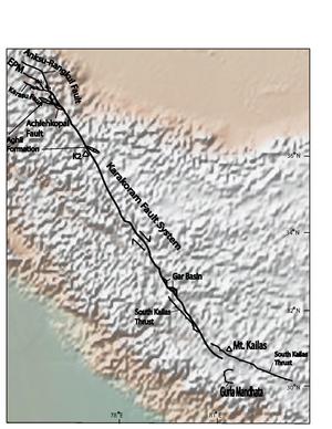
Karakoram fault information modified from and superimposed on top of topographic map of region. EPM= East Pamir Mountains
It is suggested that a late Cretaceous-Eocenegranitebatholith had been offset 1000km dextrally along the Karakoram Fault[11] based on mapping in the central Karakoram,[12][13][14][15] in nearby Ladakh-Zanskar,[16] and in south Tibet. Some researchers suggest that this might be incorrect due to associating granite that was never part of the same batholith.[4] Others researchers work have shown 600km of right lateral slip since 23 million years ago, and possibly starting 34 million years ago, based on U-Pb dating. Slip in this model has been transferred into the Indus-Yalu suture zone, as well as large scale boudinage.[17] Research in the early 1990s suggested that this slip was transferred into the South Tibetan Detachment.[18] Another suggestion is that the Karakoram fault is offset at least 500km as measured by the offset of late Paleozoic granites in the Kunlun batholith.[11] Most researchers tend to agree with the lower slip estimates. A major obstacle in measuring the total offset along the fault is in deciding what is actually a part of the fault and which faults are separate. Currently some researchers believe that the Karakoram fault merges and terminates into the Indus-Yalu suture zone at Mount Kailas.[4] Other researchers also add the Gurla Mandhata detachment, in the South-Eastern segment, to the fault.[5]
North-Western segment
The north-western segment of the Karakoram Fault is far less disputed than other areas. It terminates in the extensions of the Miuji Basin, in the Pamir Mountains, along the border between Tajikistan and Xinjiang provinces. In this north-western segment, the Karakoram Fault currently has predominantly normal fault motion, and right-lateral strike-slip offset.[4] The slip in this section of the Karakoram fault is measured to be approximately 150km, as measured by the offset of the Aghil formation. The Aghil formation is a fossiliferous carbonate formation. Before entering the Pamir region the Karakoram fault is believed to split into two distinct faults. These faults are the main Karakoram fault itself, and the Achiehkopai fault.[10]
South-Eastern segment
Most people agree that the South-Eastern portion of the fault merges into and parallels the Indus Suture Zone in South West Tibet. The southern segment of the Karakoram Fault shows that only 120km of dextral motion is evident from offset of geologic features, such as the Indus River and the South Kailas Thrust,[1] and that the strain in this region is almost entirely accommodated for by a north–south shortening in the Himalaya, just south of the Indus Suture Zone.[4] The Neogene Gar Basin in western Tibet also accommodates slip along the Karakoram fault. The basin lies within the northern approximately 1km wide area of the fault, and contains listric normal faults.[9] The Gurla Mandhata fault system is thought to be encompassed within the Karakoram fault system at its southern tip, which cause the southern tip of the fault to be approximately 36km wide.[19] Exhumation along the Gurla Mandhata detachment, which is a low-angle normal-fault system, suggest that the faults have allowed for between 36 and 66 kilometers of slip.[5]
↑ Sobel, E. R.; L. M. Schoenbohm; J. Chen; R. Thiede; D. F. Stockli; M. Sudo; M. R. Strecker (2011). "Late Miocene-Pliocene deceleration of dextral slip between Pamir and Tarim: Implications for Pamir orogensis". Earth and Planetary Science Letters. 304 (3–4): 369–378. Bibcode:2011E&PSL.304..369S. doi:10.1016/j.epsl.2011.02.012.
1 2 3 4 5 6 Searle, M. P. (February 1996). "Geological evidence against large scale pre-holocene offsets along the Karakoram fault: Implications for the limited extrusion of the Tibetan Plateau". Tectonics. 15 (1): 171–186. Bibcode:1996Tecto..15..171S. doi:10.1029/95TC01693.
1 2 3 Murphy, Mike A.; A. Yin; P. Kapp; T. M. Harrison; C. E. Manning (2002). "Isotopic characteristics of the Gurla Mandhata metamorphic core complex: Implications for the architecture of the Himalayan orogen". Geology. 35 (114): 428–447. doi:10.1130/G23774A.1.
↑ Searle, M. P.; R. F. Weinberg; W. J. Dunlap (1998). "Transpressional tectonics along the Karakoram fault zone, northern Ladakh: Constraints on Tibetan extrusion". Geological Society, London, Special Publications. 135 (1): 307–326. Bibcode:1998GSLSP.135..307S. doi:10.1144/gsl.sp.1998.135.01.20. S2CID130363239.
1 2 Sanchez, Veronica; M. Murphy; W. R. Dupré; Lin Ding; Ran Zhang (2010). "Structural evolution of the Neogene Gar Basin, Western Tibet: Implications for releasing bend development and drainage patters". Geological Society of America Bulletin. 122 (5–6): 926–945. Bibcode:2010GSAB..122..926S. doi:10.1130/B26566.1.
↑ Searle, M. P.; A. J. Rex; R. Tirrul; D. C. Rex; A. Barnicoat; B.F. Windley (1989). "Metamorphic, magmatic, and tectonic evolution of the central Karakoram in the Biafo-Baltoro-Hushe regions of northern Pakistan". Tectonics of the western Himalayas. GSA Special Papers. Vol.232. pp.47–73. doi:10.1130/SPE232-p47. ISBN978-0-8137-2232-0.
↑ Searle, M. P. (1986). "Structural evolution and sequence of thrusting in the High Himalayan Tibetan Tethys and Indus suture zones of Zanskar and Ladakh, western Himalaya". Structural Geology. 8 (8): 923–936. Bibcode:1986JSG.....8..923S. doi:10.1016/0191-8141(86)90037-4.
↑ Pecher, A. (1991). "The contact between the Higher Himalaya crystallines and the Tibetan sedimentary series: Miocene large-scale dextral shearing". Tectonics. 10 (3): 587–598. Bibcode:1991Tecto..10..587P. doi:10.1029/90TC02655.
This page is based on this Wikipedia article Text is available under the CC BY-SA 4.0 license; additional terms may apply. Images, videos and audio are available under their respective licenses.