
A convergent boundary is an area on Earth where two or more lithospheric plates collide. One plate eventually slides beneath the other, a process known as subduction. The subduction zone can be defined by a plane where many earthquakes occur, called the Wadati–Benioff zone. These collisions happen on scales of millions to tens of millions of years and can lead to volcanism, earthquakes, orogenesis, destruction of lithosphere, and deformation. Convergent boundaries occur between oceanic-oceanic lithosphere, oceanic-continental lithosphere, and continental-continental lithosphere. The geologic features related to convergent boundaries vary depending on crust types.
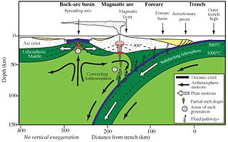
A forearc is a region in a subduction zone between an oceanic trench and the associated volcanic arc. Forearc regions are present along convergent margins and eponymously form 'in front of' the volcanic arcs that are characteristic of convergent plate margins. A back-arc region is the companion region behind the volcanic arc.
The geology of the Himalayas is a record of the most dramatic and visible creations of the immense mountain range formed by plate tectonic forces and sculpted by weathering and erosion. The Himalayas, which stretch over 2400 km between the Namcha Barwa syntaxis at the eastern end of the mountain range and the Nanga Parbat syntaxis at the western end, are the result of an ongoing orogeny — the collision of the continental crust of two tectonic plates, namely, the Indian Plate thrusting into the Eurasian Plate. The Himalaya-Tibet region supplies fresh water for more than one-fifth of the world population, and accounts for a quarter of the global sedimentary budget. Topographically, the belt has many superlatives: the highest rate of uplift, the highest relief, among the highest erosion rates at 2–12 mm/yr, the source of some of the greatest rivers and the highest concentration of glaciers outside of the polar regions. This last feature earned the Himalaya its name, originating from the Sanskrit for "the abode of the snow".

The 2002 Hindu Kush earthquakes struck in northern Afghanistan during the month of March. At least 166 people were killed with a very large and intermediate-depth mainshock on March 3. Three weeks later, at least 1,200 were killed during a moderate but shallow event that had a maximum Mercalli intensity of VII. The M7.4 and M6.1 reverse events were focused in the Hindu Kush mountain range area.

The 2008 Ziarat earthquakes hit the Pakistani province of Balochistan on October 29 with a moment magnitude of 6.4. The US Geological Survey reported that the first earthquake occurred 60 km (37 mi) north of Quetta and 185 km (115 mi) southeast of the Afghanistan city of Kandahar at 04:09 local time at a depth of 15 km (9.3 mi), at 30.653°N, 67.323°E. It was followed by another shallower magnitude 6.4 earthquake at a depth of 14 km (8.7 mi) approximately 12 hours after the initial shock, at 30.546°N, 67.447°E. 215 people were confirmed dead. More than 200 were injured, and 120,000 were rendered homeless. Qamar Zaman Chaudhry, director general of Pakistan Meteorological Department, stated the quake epicenter was 70 miles (110 km) north of Quetta, and about 600 km (370 mi) southwest of Islamabad.

The 1819 Rann of Kutch earthquake occurred at about 18:45 to 18:50 local time on 16 June 1819. It had an estimated magnitude ranging from 7.7 to 8.2 on the moment magnitude scale and a maximum perceived intensity of XI (Extreme) on the Mercalli intensity scale. It triggered a tsunami and caused at least 1,543 deaths. The earthquake caused an area of subsidence that formed the Sindri Lake and a local zone of uplift to the north about 80 km (50 mi) long, 6 km (3.7 mi) wide and 6 m (20 ft) high that dammed the Koree / Kori / Puran / Nara river. This natural dam was known as the Allah Bund.

On 11 June 2012, two moderate earthquakes struck northern Afghanistan, causing a large landslide. The landslide buried the town of Sayi Hazara, trapping 71 people. After four days of digging, only five bodies were recovered and the search was called off. Overall, 75 people were killed and 13 others were injured.
Thick-skinned deformation is a geological term which refers to crustal shortening that involves basement rocks and deep-seated faults as opposed to only the upper units of cover rocks above the basement which is known as thin-skinned deformation. While thin-skinned deformation is common in many different localities, thick-skinned deformation requires much more strain to occur and is a rarer type of deformation.

A deep-focus earthquake in seismology is an earthquake with a hypocenter depth exceeding 300 km. They occur almost exclusively at convergent boundaries in association with subducted oceanic lithosphere. They occur along a dipping tabular zone beneath the subduction zone known as the Wadati–Benioff zone.
The 2013 Saravan earthquake occurred with a moment magnitude of 7.7 at 15:14 pm IRDT (UTC+4:30) on 16 April. The shock struck a mountainous area between the cities of Saravan and Khash in Sistan and Baluchestan province, Iran, close to the border with Pakistan, with a duration of about 25 seconds. The earthquake occurred at an intermediate depth in the Arabian plate lithosphere, near the boundary between the subducting Arabian plate and the overriding Eurasian plate at a depth of about 80 km.
The December 2015 Hindu Kush earthquake occurred with a moment magnitude of 6.3 in South Asia on 25 December 2015. One woman was killed in Pakistan. At least 100 people were injured in Pakistan and Afghanistan. The quake was also strongly felt in Tajikistan and India. The epicenter of the earthquake was in the Afghanistan-Tajikistan border region at a depth of 203.4 km.
The 1906 Manasi earthquake (玛纳斯地震), also known as the Manas earthquake occurred in the morning of December 23, 1906, at 02:21 UTC+8:00 local time or December 22, 18:21 UTC. It measured 8.0–8.3 on the moment magnitude scale and 8.3 on the surface-wave magnitude scale. The epicenter of this earthquake is located in Manas County, Xinjiang, China. An estimated 280–300 people died and another 1,000 more were injured by the earthquake.
An earthquake occurred on June 19, 1718, in Tongwei County, Gansu Province, Qing dynasty, present-day China. The estimated surface wave magnitude (Ms ) 7.5 earthquake was designated a maximum Modified Mercalli intensity of X (Extreme), causing tremendous damage and killing 73,000 people.
The 1983 Hindu Kush earthquake occurred south of Fayzabad, Badakhshan in northeast Afghanistan at 03:52 PST on December 31, 1983, near the border with Pakistan and the USSR. Striking 214.5 km beneath the Hindu Kush mountains, the moment magnitude 7.4 quake affected three countries, killing at least 26 people and injuring several hundred.

The Lenin Peak disaster occurred on 13 July 1990 when 43 climbers were killed during an avalanche on the 7,134-meter-high mountain peak in northeast Tajikistan and Kyrgyzstan. The deadly avalanche was triggered by a moment magnitude scale 6.4 earthquake which struck at a depth of 216.8 km beneath the Hindu Kush mountains in neighbouring Afghanistan. The incident is believed to be the deadliest mountaineering disaster in history.
The 1654 Tianshui earthquake occurred on July 21 in Tianshui, Gansu Province, Ming dynasty sometime between 21:00 and 23:00 local time. The event had an estimated moment magnitude of 7.0 and was assigned a maximum intensity of XI on the China seismic intensity scale. Resulting in extreme damage and affecting at least four provinces, the quake killed approximately 30,000 people.
The 1955 Zheduotang earthquake, also known as the Kangding earthquake occurred on April 14 at 09:29:02 local time near the city of Kangding in the Garzê Tibetan Autonomous Prefecture, Sichuan. The earthquake had a moment magnitude of 7.0 and a surface wave magnitude of 7.1 and struck at a depth of 10 km. Severe damage occurred in Kangding with the loss of 70 lives.
The 1858 Prome earthquake occurred on August 24 at 15:38 local time in British Burma. The earthquake occurred with a magnitude of 7.6–8.3 on the moment magnitude scale. It had an epicenter in near the city of Pyay (Prome), Bago. The shock was felt with a maximum Modified Mercalli intensity of XI (Extreme) for about one minute. Severe damage was reported in Bago, and off the coast of Rakhine, an island sunk.
On September 5, 2022, a reverse faulting earthquake with a moderate magnitude of 5.1 struck Kunar Province, Afghanistan, close to the city of Jalalabad.
On 21 March 2023, a magnitude 6.5 earthquake struck Badakhshan Province, Afghanistan, with an intermediate depth of approximately 187 km (116 mi). The epicenter of the earthquake was 40 km (25 mi) south-southeast of Jurm.
