Focal mechanism

Last updated

Focal mechanism 01.jpg

The focal mechanism of an earthquake describes the deformation in the source region that generates the seismic waves. In the case of a fault-related event, it refers to the orientation of the fault plane that slipped, and the slip vector and is also known as a fault-plane solution. Focal mechanisms are derived from a solution of the moment tensor for the earthquake, which itself is estimated by an analysis of observed seismic waveforms. The focal mechanism can be derived from observing the pattern of "first motions", whether the first arriving P waves break up or down. This method was used before waveforms were recorded and analysed digitally, and this method is still used for earthquakes too small for easy moment tensor solution. Focal mechanisms are now mainly derived using semi-automatic analysis of the recorded waveforms. [1]

Contents

Moment tensor solutions

Focal Mechanisms.svg

The moment tensor solution is displayed graphically using a so-called beachball diagram. The pattern of energy radiated during an earthquake with a single direction of motion on a single fault plane may be modelled as a double couple, which is described mathematically as a special case of a second order tensor (similar to those for stress and strain) known as the moment tensor.

Earthquakes not caused by fault movement have quite different patterns of energy radiation. In the case of an underground nuclear explosion, for instance, the seismic moment tensor is isotropic, and this difference allows such explosions to be easily discriminated from their seismic response. This is an essential part of monitoring to distinguish between earthquakes and explosions for the Comprehensive Test Ban Treaty.

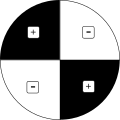
Fault types with corresponding beach ball plots [2]
Left-lateral

strike slip

Right-lateral

strike slip

Normal

dip-slip

Thrust/reverse

dip-slip

StrikeSlipFault Mirrored.svg StrikeSlipFault.svg NormalFault.svg ThrustFault.svg
Left-lateral strike slip.svg Right-lateral strike slip.svg Normal dip-slip.svg Thrust reverse dip-slip.svg

Graphical representation ("beachball plot")

Focal mechanism.svg

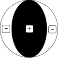
The data for an earthquake is plotted using a lower-hemisphere stereographic projection. The azimuth and take-off angle are used to plot the position of an individual seismic record. The take-off angle is the angle from the vertical of a seismic ray as it emerges from the earthquake focus. These angles are calculated from a standard set of tables that describe the relationship between the take-off angle and the distance between the focus and the observing station. By convention, filled symbols plot data from stations where the P-wave first motion recorded was up (a compressive wave), hollow symbols for down (a tensional wave), and crosses for stations with arrivals too weak to get a sense of motion. If there are sufficient observations, one may draw two well-constrained orthogonal great circles that divide the compressive from the tensional observations, and these are the nodal planes. Observations from stations with no clear first motion normally lie close to these planes. By convention, the compressional quadrants are colour-filled, and the tensional left is white. The two nodal planes intersect at the N (neutral)-axis. The P and T axes are also often plotted; with the N axis, these three directions respectively match the directions of the maximum, minimum, and intermediate principal compressive stresses associated with the earthquake. The P-axis is plotted in the centre of the white segment, and the T-axis in the centre of the colour-filled segment.

USGS focal mechanism for the 2004 Indian Ocean earthquake Sumatra 2004 focal mechanism.png
USGS focal mechanism for the 2004 Indian Ocean earthquake

The fault plane responsible for the earthquake will parallel one of the nodal planes; the other is called the auxiliary plane. It is impossible to determine solely from a focal mechanism which of the nodal planes is the fault plane. Other geological or geophysical evidence is needed to remove the ambiguity. The slip vector, the direction of motion of one side of the fault relative to the other, lies within the fault plane, 90 degrees from the N-axis.

For example, in the 2004 Indian Ocean earthquake, the moment tensor solution gives two nodal planes, one dipping northeast at 6 degrees and one dipping southwest at 84 degrees. In this case, the earthquake can be confidently associated with the plane dipping shallowly to the northeast, as this is the orientation of the subducting slab as defined by historical earthquake locations and plate tectonic models. [3]

Fault plane solutions are useful for defining the style of faulting in seismogenic volumes at depth for which no surface expression of the fault plane exists or where an ocean covers the fault trace. A simple example of a successful test of the hypothesis of sea floor spreading was the demonstration that the sense of motion along oceanic transform faults [4] is opposite to what would be expected in classical geologic interpretation of the offset oceanic ridges. This was done by constructing fault plane solutions of earthquakes in oceanic faults, which showed beach ball plots of strike-slip nature (see figures), with one nodal plane parallel to the fault and the slip in the direction required by the idea of seafloor spreading from the ridges. [5]

Fault plane solutions also played a crucial role in discovering that the deep earthquake zones in some subducting slabs are under compression while others are under tension. [6] [7]

Beach ball calculator

There are several programs available to prepare Focal Mechanism Solutions (FMS). BBC, a MATLAB-based toolbox, is available to prepare the beach ball diagrams. This software plots the first motion polarity data as it arrives at different stations. The compression and dilation are separated using mouse help. A final diagram is prepared automatically. [8]

See also

Related Research Articles

<span class="mw-page-title-main">Earthquake</span> Sudden movement of the Earths crust

An earthquake is the shaking of the surface of the Earth resulting from a sudden release of energy in the Earth's lithosphere that creates seismic waves. Earthquakes can range in intensity, from those that are so weak that they cannot be felt, to those violent enough to propel objects and people into the air, damage critical infrastructure, and wreak destruction across entire cities. The seismic activity of an area is the frequency, type, and size of earthquakes experienced over a particular time. The seismicity at a particular location in the Earth is the average rate of seismic energy release per unit volume. The word tremor is also used for non-earthquake seismic rumbling.

In seismology, an aftershock is a smaller earthquake that follows a larger earthquake, in the same area of the main shock, caused as the displaced crust adjusts to the effects of the main shock. Large earthquakes can have hundreds to thousands of instrumentally detectable aftershocks, which steadily decrease in magnitude and frequency according to a consistent pattern. In some earthquakes the main rupture happens in two or more steps, resulting in multiple main shocks. These are known as doublet earthquakes, and in general can be distinguished from aftershocks in having similar magnitudes and nearly identical seismic waveforms.

The moment magnitude scale is a measure of an earthquake's magnitude based on its seismic moment. It was defined in a 1979 paper by Thomas C. Hanks and Hiroo Kanamori. Similar to the local magnitude/Richter scale (ML ) defined by Charles Francis Richter in 1935, it uses a logarithmic scale; small earthquakes have approximately the same magnitudes on both scales. Despite the difference, news media often says "Richter scale" when referring to the moment magnitude scale.

<span class="mw-page-title-main">Ryukyu Trench</span> Oceanic trench along the southeastern edge of Japans Ryukyu Islands in the Pacific Ocean

The Ryukyu Trench, also called Nansei-Shotō Trench, is a 1398 km (868 mi) long oceanic trench located along the southeastern edge of Japan's Ryukyu Islands in the Philippine Sea in the Pacific Ocean, between northeastern Taiwan and southern Japan. The trench has a maximum depth of 7460 m (24,476 ft). The trench is the result of oceanic crust of the Philippine Plate obliquely subducting beneath the continental crust of the Eurasian Plate at a rate of approximately 52 mm/yr. In conjunction with the adjacent Nankai Trough to the northeast, subduction of the Philippine plate has produced 34 volcanoes. The largest earthquake to have been recorded along the Ryukyu Trench, the 1968 Hyūga-nada earthquake, was magnitude 7.5 and occurred along the northernmost part of the trench on 1 April 1968. This earthquake also produced a tsunami.

<span class="mw-page-title-main">Wadati–Benioff zone</span> Planar zone of seismicity corresponding with the down-going slab

A Wadati–Benioff zone is a planar zone of seismicity corresponding with the down-going slab in a subduction zone. Differential motion along the zone produces numerous earthquakes, the foci of which may be as deep as about 670 km (420 mi). The term was named for the two seismologists, Hugo Benioff of the California Institute of Technology and Kiyoo Wadati of the Japan Meteorological Agency, who independently discovered the zones.

A slow earthquake is a discontinuous, earthquake-like event that releases energy over a period of hours to months, rather than the seconds to minutes characteristic of a typical earthquake. First detected using long term strain measurements, most slow earthquakes now appear to be accompanied by fluid flow and related tremor, which can be detected and approximately located using seismometer data filtered appropriately. That is, they are quiet compared to a regular earthquake, but not "silent" as described in the past.

<span class="mw-page-title-main">Queen Charlotte Fault</span> Active transform fault in Canada and Alaska

The Queen Charlotte Fault is an active transform fault that marks the boundary of the North American plate and the Pacific plate. It is Canada's right-lateral strike-slip equivalent to the San Andreas Fault to the south in California. The Queen Charlotte Fault forms a triple junction south with the Cascadia subduction zone and the Explorer Ridge. The Queen Charlotte Fault (QCF) forms a transpressional plate boundary, and is as active as other major transform fault systems in terms of slip rates and seismogenic potential. It sustains the highest known deformation rates among continental or continent-ocean transform systems globally, accommodating greater than 50mm/yr dextral offset. The entire approximately 900 km offshore length has ruptured in seven greater than magnitude 7 events during the last century, making the cumulative historical seismic moment release higher than any other modern transform plate boundary system.

In seismology, a supershear earthquake is an earthquake in which the propagation of the rupture along the fault surface occurs at speeds in excess of the seismic shear wave (S-wave) velocity. This causes an effect analogous to a sonic boom.

In seismology, doublet earthquakes – and more generally, multiplet earthquakes – were originally identified as multiple earthquakes with nearly identical waveforms originating from the same location. They are now characterized as single earthquakes having two main shocks of similar magnitude, sometimes occurring within tens of seconds, but sometimes separated by years. The similarity of magnitude – often within 0.4 magnitude – distinguishes multiplet events from aftershocks, which start at about 1.2 magnitude less than the parent shock and decrease in magnitude and frequency according to known laws.

Shear wave splitting, also called seismic birefringence, is the phenomenon that occurs when a polarized shear wave enters an anisotropic medium. The incident shear wave splits into two polarized shear waves. Shear wave splitting is typically used as a tool for testing the anisotropy of an area of interest. These measurements reflect the degree of anisotropy and lead to a better understanding of the area's crack density and orientation or crystal alignment. We can think of the anisotropy of a particular area as a black box and the shear wave splitting measurements as a way of looking at what is in the box.

The 1996 Biak earthquake, or the Irian Jaya earthquake, occurred on 17 February at 14:59:30 local time near Biak Island, Indonesia. The earthquake, which occurred on the New Guinea Trench, had a moment magnitude of 8.2 and a maximum Mercalli intensity of IX (Violent). The run-up height of the generated tsunami reached 7.7 m (25 ft). The disaster left at least 108 people dead, 423 injured, and 58 missing. It damaged or destroyed 5,043 houses which subsequently made another 10,000 homeless. At Korim, 187 houses were destroyed. Various countries and organizations provided aid and relief in the aftermath of the earthquake.

<span class="mw-page-title-main">1994 offshore Sanriku earthquake</span> Earthquake in Japan

The 1994 offshore Sanriku earthquake occurred on December 28, 1994, at 12:19 UTC. This was a magnitude Mw 7.7 earthquake with epicenter located in the Pacific Ocean at about 180 km east of Hachinohe, Aomori. The intensity reached shindo 6 in Hachinohe, Aomori, about 187.6 km from epicenter. It could be felt in Tokyo, about 632.9 km from epicenter, with shindo 2. The Japanese Meteorological Agency put the magnitude at MJMA 7.5. Slip associated with this earthquake continued for more than a year and it has been termed an 'ultra-slow earthquake'.

The 1906 Aleutian Islands earthquake occurred at 00:11 UTC on August 17. It had an estimated seismic moment of 3.8 x 1028 dyn cm−1, equivalent to a magnitude of 8.35 on the moment magnitude scale. This earthquake was followed thirty minutes later by the 1906 Valparaíso earthquake in Chile, but the two events are not thought to be linked. Due to the remote location, there are no reports of damage associated with this earthquake. A transpacific tsunami reported from Japan and Hawaii was triggered by the Chilean event, rather than the Aleutian Islands earthquake.

<span class="mw-page-title-main">Deep-focus earthquake</span>

A deep-focus earthquake in seismology is an earthquake with a hypocenter depth exceeding 300 km. They occur almost exclusively at convergent boundaries in association with subducted oceanic lithosphere. They occur along a dipping tabular zone beneath the subduction zone known as the Wadati–Benioff zone.

<span class="mw-page-title-main">2021 Chignik earthquake</span> 7th largest earthquake in the US

An earthquake occurred off the coast of the Alaska Peninsula on July 28, 2021, at 10:15 p.m. local time. The large megathrust earthquake had a moment magnitude of 8.2 according to the United States Geological Survey (USGS). A tsunami warning was issued by the National Oceanic and Atmospheric Administration (NOAA) but later cancelled. The mainshock was followed by a number of aftershocks, including three that were of magnitude 5.9, 6.1 and 6.9 respectively.

The 2021 Loyalty Islands earthquake was a 7.7 magnitude earthquake that struck offshore between Vanuatu and New Caledonia on February 11, 2021 at 00:19 local time. It is the 4th largest earthquake of 2021.

<span class="mw-page-title-main">Oblique subduction</span> Tectonic process

Oblique subduction is a form of subduction for which the convergence direction differs from 90° to the plate boundary. Most convergent boundaries involve oblique subduction, particularly in the Ring of Fire including the Ryukyu, Aleutian, Central America and Chile subduction zones. In general, the obliquity angle is between 15° and 30°. Subduction zones with high obliquity angles include Sunda trench and Ryukyu arc.

The 1979 Saint Elias earthquake occurred near noon local time on the 28th of February. It measured Mw 7.4–7.6. Though the maximum recorded Modified Mercalli intensity was VII, damage was minimal and there were no casualties due to the remoteness of the faulting. The epicenter lies near the Alaskan border between America and Canada.

<span class="mw-page-title-main">1940 Shakotan earthquake</span> Earthquake in Japan

The 1940 Shakotan earthquake occurred on August 2 at 00:08:22 JST with a moment magnitude (Mw ) of 7.5 and maximum JMA seismic intensity of Shindo 4. The shock had an epicenter off the coast of Hokkaido, Japan. Damage from the shock was comparatively light, but the accomanying tsunami was destructive. The tsunami caused 10 deaths and 24 injuries on Hokkaido, and destroyed homes and boats across the Sea of Japan. The highest tsunami waves were recorded at the coast of Russia while along the coast of Hokkaido, waves were about 2 m.

<span class="mw-page-title-main">1995 Kozani–Grevena earthquake</span> Large earthquake in Greece

The 1995 Kozani–Grevena earthquake was a large earthquake that occurred on May 13, 1995, in the region of Western Macedonia, Greece. With a magnitude of 6.6 on the moment magnitude scale, this earthquake caused locally significant damage to villages and towns in the regions of Kozani and Grevena. 25 people were injured and monetary damages of $450 million were caused as a result of the earthquake.

References

  1. Sipkin, Stuart A. (1994). "Rapid determination of global moment-tensor solutions". Geophysical Research Letters. 21 (16): 1667–1670. Bibcode:1994GeoRL..21.1667S. doi:10.1029/94GL01429.
  2. Yongliang Wang, Yang Ju, Yongming Yang (2018), "Adaptive Finite Element-Discrete Element Analysis for Microseismic Modelling of Hydraulic Fracture Propagation of Perforation in Horizontal Well considering Pre-Existing Fractures", Shock and Vibration, vol. 2018, pp. 1–14, doi: 10.1155/2018/2748408 , ISSN   1070-9622 {{citation}}: CS1 maint: multiple names: authors list (link)
  3. Sibuet, Jean-Claude; Rangin, Claude; Lepichon, Xavier Le; Singh, Satish; Cattaneo, Antonio; Graindorge, David; Klingelhoefer, Frauke; Lin, Jing-Yi; Malod, Jacques; Maury, Tanguy; Schneider, Jean-Luc; Sultan, Nabil; Umber, Marie; Yamaguchi, Haruka; "Sumatra Aftershocks" team (2007). "26th December 2004 great Sumatra–Andaman earthquake: Co-seismic and post-seismic motions in northern Sumatra" (PDF). Earth and Planetary Science Letters. 263 (1–2): 88–103. Bibcode:2007E&PSL.263...88S. doi:10.1016/j.epsl.2007.09.005.
  4. Wilson, J. Tuzo (1965). "A new class of faults and their bearing on continental drift". Nature . 207 (4995): 343–347. Bibcode:1965Natur.207..343W. doi:10.1038/207343a0. S2CID   4294401.
  5. Sykes, Lynn R. (1967). "Mechanism of earthquakes and nature of faulting on the mid-oceanic ridges". Journal of Geophysical Research. 72 (8): 2131–2153. Bibcode:1967JGR....72.2131S. doi:10.1029/JZ072i008p02131.
  6. Isacks, Bryan; Molnar, Peter (1971). "Distribution of stresses in the descending lithosphere from a global survey of focal-mechanism solutions of mantle earthquakes". Reviews of Geophysics and Space Physics. 9 (1): 103–174. Bibcode:1971RvGSP...9..103I. doi:10.1029/RG009i001p00103.
  7. Vassiliou, Marius S. (1984). "The state of stress in subducting slabs as revealed by earthquakes analysed by moment tensor inversion". Earth and Planetary Science Letters. 69 (1): 195–202. Bibcode:1984E&PSL..69..195V. doi:10.1016/0012-821X(84)90083-9.
  8. Shahzad, Faisal (2006). Software development for fault plane solution and isoseismal map (MSc). Islamabad: Quaid-i-Azam University.