Province of Mantua

Last updated

Province of Mantua
Mantova - Piazza delle Erbe.jpg
Palazzo della Cervetta, the provincial seat
Flag of the Province of Mantua.svg
Provincia di Mantova-Stemma.svg
Mantova in Italy.svg
Map highlighting the location of the province of Mantua in Italy
CountryFlag of Italy.svg  Italy
Region Lombardy
Capital(s) Mantua
Comuni 70
Government
  PresidentCarlo Bottani
Area
  Total2,339 km2 (903 sq mi)
Population
 (31 May 2015)
  Total413,663
  Density180/km2 (460/sq mi)
GDP
[1]
  Total€12.377 billion (2015)
  Per capita€29,904 (2015)
Time zone UTC+1 (CET)
  Summer (DST) UTC+2 (CEST)
Vehicle registration MN
ISTAT 020

The province of Mantua (Italian : provincia di Mantova; Mantuan, Lower Mantuan: pruvincia ad Mantua; Upper Mantuan: pruinsa de Mantua) is a province in the Lombardy region of Italy. Its capital is the city of Mantua. It is bordered to the north-east by the province of Verona, to the east by the province of Rovigo, to the south by the province of Ferrara, province of Modena, province of Reggio Emilia and province of Parma, to the west by the province of Cremona and to the north-west by the province of Brescia.

Contents

History

Founded in the tenth century BC on the plain formed by meanders of the River Mincio, Mantua became an Etruscan town and important trading post for pottery and agricultural products. Despite its defensible position, it was unable to withstand the Celtic invaders in the sixth and fifth centuries BC who overwhelmed it, and the whole area was later conquered by the Romans. [2]

By the fifth century AD, the Western Roman Empire was collapsing. Mantua was overrun by a series of invaders, including the Visigoths, Vandals, and Ostrogoths. After 568 the Lombards seized control of the part of northern Italy which is now known as Lombardy and included Mantua. [2]

The current administrative boundaries of the province have deep historical roots, corresponding largely to the Duchy of Mantua, which was a fief of the Holy Roman Empire. The Napoleonic Department of the Mincio became the Province of Mantua at the birth of the Kingdom of Lombardy–Venetia in 1815. Following the Battle of Solferino on 24 June 1859, Franco-Piedmontese troops conquered Lombardy up to the right bank of the Mincio, and the resulting Armistice of Villafranca of 11 June 1859 between France and Austria called for the new provincial boundaries, splitting in two the part of the previous Province of Mantova that was crossed by the new international border. Following the Third Italian War of Independence all of Mantua passed to the Kingdom of Italy. The new provincial boundaries came into effect after laws enacted in 1868. The coat of arms of the province, containing the symbols of Mantua, Bozzolo and Castiglione delle Stiviere, embodies the union of those three areas and was adopted in place of the previous one.

Geography

The Province of Mantua is bounded by several rivers. To the west, the River Oglio provides the border with the Province of Cremona. To the south it is bounded by the River Po, on the other side of which are the provinces of Ferrara, Modena, Reggio Emilia and Parma. To the east the River Mincio provides the border with the Province of Verona and the Province of Rovigo, and to the northwest lies the Province of Brescia. The total area of the province is 2,340 square kilometres (900 sq mi). [3] The River Po is subject to flooding and much of the bank is raised by levees.

Protected areas

Mincio river in the countryside Flickr - lo.tangelini - Il Mincio.jpg
Mincio river in the countryside

There are a number of nature reserves and protected areas in the province. The Parco regionale del Mincio was established on 8 September 1984 with an area of approximately 16,000 hectares. It includes several nature reserves and has a range of habitats including moraines, hills, plains, and the meandering riverbeds in the complex of lakes of Mantua. Birds found in the park include storks, herons, purple herons, egrets, night herons, kingfishers, bee-eaters, coots, moorhens, peregrine falcons, hawks, great crested grebe and black kite.

The Parco dell'Oglio Sud is another regional park that lies on the boundary of the province with the province of Cremona. It was established in 1988 and has an area of about 12,800 hectares. It is a river park that runs along the stretch of the river Oglio which forms the boundary. It lies to the south of Lake Iseo and the administrative centre is at Calvatone. Birds present in this park include great egret, grey heron, Montagu's harrier, Eurasian scops owl, bearded reedling, woodcock, barred warbler, crested lark, sedge warbler, moustached warbler, little egret, Eurasian hobby and ferruginous duck.

The Riserva naturale Bosco Fontana is a state nature reserve with an area of about 23,300 hectares. It is a wooded area that is a remnant of the natural forests that covered the Po valley in ancient times. It is a dense marshy forest composed mainly of Turkey oaks, pedunculate oaks, hornbeams, limes, poplars, elms and alders, which are accompanied by numerous species of shrubby undergrowth. There are glades with abundant wildflowers and fungi flourish among the trees, an important factor being the richness of the groundwater. Among the mammals found in the reserve are the least weasel, beech marten and European polecat, and the birds include the common buzzard, the great spotted woodpecker and the Eurasian wryneck. [4]

Government

Dsc 1150 Mantua.jpg
Mantova-Piazza Erbe.jpg
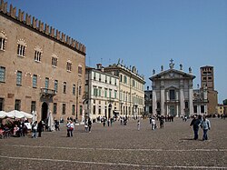
Mantua is the administrative center of the province where all the provincial institutions are seated.
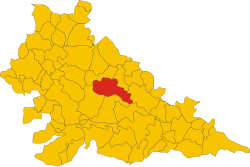
Map showing the 70 comuni of the province. The city of Mantua is shown in red. Map of comune of Mantua (province of Mantua, region Lombardy, Italy).svg
Map showing the 70 comuni of the province. The city of Mantua is shown in red.

The Province of Mantua is an administrative body of intermediate level between a municipality ( comune ) and Lombardy region.

The three main functions devolved to the Province of Mantua are:

As an administrative institution, the Province of Mantua has its own elected bodies. From 1948 to 1993 the President of the Province of Mantua was chosen by the members of the Provincial Council, elected every five years by citizens. From 1993 to 2016, under provisions of the 1993 local administration reform, the President of the Province was chosen by popular election, originally every four, then every five years.

On 3 April 2014, the Italian Chamber of Deputies gave its final approval to the Law n.56/2014 which involves the transformation of the Italian provinces into "institutional bodies of second level". According to the 2014 reform, each province is headed by a President (or Commissioner) assisted by a legislative body, the Provincial Council, and an executive body, the Provincial Executive. President (Commissioner) and members of Council are elected together by mayors and city councilors of each municipality of the province respectively every four and two years. The Executive is chaired by the President (Commissioner) who appoint others members, called assessori . Since 2016, the President (Commissioner) and other members of the Council do not receive a salary. [5]

In each province, there is also a Prefect ( prefetto ), a representative of the central government who heads an agency called prefettura-ufficio territoriale del governo. The Questor (questore) is the head of State's Police ( Polizia di Stato ) in the province and his office is called questura. There is also a province's police force depending from local government, called provincial police (polizia provinciale).

This is a partial list of the Presidents of the Province since 1975:

PresidentTerm startTerm end Party
Maurizio Lotti19751983 PCI
Guido Contessa19831985PCI
Massimo Chiaventi19851993PCI
Davide Boni20 June 199312 May 1997 LN
Tiziana Gualtieri12 May 199728 May 2001 PPI
Maurizio Fontanili28 May 200130 May 2011 PD
Alessandro Pastacci30 May 201131 August 2016 PD
Beniamino Morselli [lower-alpha 1] 31 August 201619 December 2021 PD
Carlo Bottani [lower-alpha 2] 19 December 2021Incumbent Ind
Notes
  1. Mayor of San Giorgio Bigarello.
  2. Mayor of Curtatone.

Economy

Fields near Po river in Viadana Sunset - Via Argine Po, Viadana, Mantova, Italy - March 31, 2012.jpg
Fields near Po river in Viadana

Despite Mantuan landscape is primarily an agricultural one and the primary sector accounted for the 6% of local GDP in 2003, much above Italian average, the province has an historically strong industrial sector, which accounts for 37% of the GDP, while the tertiary sector holds the remaining 56%. [6] Overall, the gross domestic product of the province was estimated in 2003 at over €10 billion. [6]

The productivity of agriculture is enhanced by a well-developed use of fertilizers and the traditional abundance of water. It is largely flat and the soil is very fertile and is intensively irrigated, boosted since the Middle Ages by the construction of a wide net of irrigation canals which were partly designed by Leonardo da Vinci. Crops grown include wheat, maize, rice, sugar beet, potatoes and vegetables. Olives, grapes, chestnuts and many other sorts of fruit are grown; mulberry plants are grown for their contribution to silk production, or sericulture. The lower plains are characterized by fodder crops, which are mowed up to eight times a year. Cattle are also bred and cheese and other dairy products are manufactured. The main exports from the province include cereals, rice, cheese and silk, but most industrial goods need to be imported. [7]

Municipalities

Here is a list of the most populated municipalities of the province.

RankMunicipalityPopulation
as of 2017
Area
(km2)
Density
(inhabitants/km2)
Altitude
(mslm)
1st Mantua 49,40363.81774.219
2nd Castiglione delle Stiviere 23,70442.02564.1116
3rd Suzzara 21,28860.10354.220
4th Viadana 20,151103,84194.126
5th Porto Mantovano 16,51337.44441.129

Municipal government

Here is a list of the municipal government in cities and towns with more than 15,000 inhabitants:

MunicipalityMayor PartyExecutiveTerm
Mantua Mattia Palazzi PD PD   SI 2020–2025
Castiglione delle Stiviere Enrico Volpi LN FI   LN   FdI 2022–2027
Suzzara Ivan Ongari PD PD   SI 2019–2024
Viadana Nicola Cavatorta LN FI   LN   FdI 2020–2025
Porto Mantovano Massimo Salvarani PD PD   Ind 2019–2024

See also

Related Research Articles

<span class="mw-page-title-main">Mantua</span> City in Lombardy, Italy

Mantua is a comune (municipality) in the Italian region of Lombardy, and capital of the province of the same name.

<span class="mw-page-title-main">Solferino</span> Comune in Lombardy, Italy

Solferino is a small town and municipality in the province of Mantua, Lombardy, northern Italy, approximately 10 kilometres (6.2 mi) south of Lake Garda.

<span class="mw-page-title-main">Cisalpine Republic</span> 1797–1802 French client state in northern Italy

The Cisalpine Republic was a sister republic of France in Northern Italy that existed from 1797 to 1799, with a second version until 1802.

<span class="mw-page-title-main">Province of Brescia</span> Province of Italy

The province of Brescia is a province in the Lombardy region of Italy. It has a population of some 1,265,964 and its capital is the city of Brescia.

<span class="mw-page-title-main">Province of Cremona</span> Province of Italy

The province of Cremona is a province in the Lombardy region of Italy. Its capital city is Cremona.

<span class="mw-page-title-main">Mincio</span> River in Italy

The Mincio is a river in the Lombardy region of northern Italy.

<span class="mw-page-title-main">Polesine</span>

Polesine is a geographic and historic area in the north-east of Italy whose limits varied through centuries; it had also been known as Polesine of Rovigo for some time.

<span class="mw-page-title-main">Sabbioneta</span> Comune in Lombardy, Italy

Sabbioneta is a town and comune in the province of Mantua, Lombardy region, Northern Italy. It is situated about 30 kilometres (19 mi) north of Parma, not far from the northern bank of the Po River. It is one of I Borghi più belli d'Italia. It was inscribed in the World Heritage List in 2008.

<span class="mw-page-title-main">Goito</span> Comune in Lombardy, Italy

Goito is a comune with a population of 10,005 in the Province of Mantua in Lombardy. Goito is 20 kilometres (12 mi) north of Mantua on the road leading to Brescia and Lake Garda, and straddles the old east–west Via Postumia between Cremona and Verona. The town is on the right bank of the Mincio River at a key crossing. The birthplace of Sordello, Goito is part of the historic region known as Alto Mantovano and was the site of a notable fortress.

<span class="mw-page-title-main">Asola, Lombardy</span> Comune in Lombardy, Italy

Asola is a comune in the province of Mantua, Lombardy. It received the honorary title of city with a presidential decree of October 23, 1951.

<span class="mw-page-title-main">Oglio</span> River in Lombardy, Italy

The Oglio is a left-side tributary of the river Po in Lombardy, Italy. It is 280 kilometres (170 mi) long. In the hierarchy of the Po's tributaries, with its 280 kilometres (170 mi) of length, it occupies the 2nd place per length, while it is the 4th per basin surface, and the 3rd per average discharge at the mouth.

<span class="mw-page-title-main">Gazoldo degli Ippoliti</span> Comune in Lombardy, Italy

Gazoldo degli Ippoliti is a comune (municipality) in the Province of Mantua in the Italian region Lombardy, located about 110 kilometres (68 mi) east of Milan and about 15 kilometres (9 mi) west of Mantua.

<span class="mw-page-title-main">Gonzaga, Lombardy</span> Comune in Lombardy, Italy

Gonzaga is a comune (municipality) in the Province of Mantua in the Italian region Lombardy, located about 140 kilometres (87 mi) southeast of Milan and about 25 kilometres (16 mi) south of Mantua. Located in a region known as the "Lower Mantuan" is notable for being the ancestral home of the House of Gonzaga, rulers of the Duchy of Mantua between 1328 and 1707.

<span class="mw-page-title-main">Viadana, Lombardy</span> Comune in Lombardy, Italy

Viadana is a comune (municipality) in the Province of Mantua in the Italian region Lombardy, located about 120 kilometres (75 mi) southeast of Milan and about 35 kilometres (22 mi) southwest of Mantua.

<span class="mw-page-title-main">Volta Mantovana</span> Comune in Lombardy, Italy

Volta Mantovana is a comune (municipality) in the Province of Mantua in the Italian region Lombardy, located about 120 kilometres (75 mi) east of Milan and about 20 kilometres (12 mi) northwest of Mantua.

<span class="mw-page-title-main">Mantova railway station</span> Railway station in Italy

Mantua Railway Station is the main station of Comune of Mantua in the Region of Lombardy, northern Italy.

The following is a timeline of the history of the city of Mantua in the Lombardy region of Italy.

<span class="mw-page-title-main">Geography of Lombardy</span>

Lombardy is an administrative region of Italy that is split into four geographic regions — mountains, alpine forest, and the upper and lower plains south of the Po river. These are crossed and dotted by dozens of rivers and lakes, the latter of which include some of the largest in Italy. The territory is the fourth largest in Italy by surface area with 24,000 square kilometres (9,300 sq mi).

<span class="mw-page-title-main">Upper Mantua</span> Geographical area in Lombardy, Italy

Upper Mantua is a geographical area located northwest of the city of Mantua in the province of the same name and bordering the provinces of Brescia and Verona, bordered to the north by the morainic hills of Lake Garda, to the east by the province of Verona, to the northwest by the province of Brescia, and to the south by the plains of Middle Mantua.

References

  1. Regions and Cities > Regional Statistics > Regional Economy > Regional Gross Domestic Product (Small regions TL3), OECD.Stats. Accessed on 16 November 2018.
  2. 1 2 Ring, Trudy; Watson, Noelle; Schellinger, Paul (2013). Southern Europe: International Dictionary of Historic Places. Taylor & Francis. pp. 416–. ISBN   978-1-134-25965-6.
  3. The Times Comprehensive Atlas of the World (13 ed.). Times Books. 2011. p. 76. ISBN   9780007419135.
  4. "Riserva Statale Bosco Fontana". Corpo Forestale dello Stato. Retrieved 18 October 2015.
  5. "Le elezioni". 25 November 2016.
  6. 1 2 (in Italian) Struttura economica della provincia di Mantova
  7. Comprehensive Dictionary of the World. Mittal Publications. 1992. p. 613. GGKEY:RC6C27C4NE1.


44°54′N12°30′E / 44.900°N 12.500°E / 44.900; 12.500