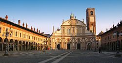
Province of Pavia

Last updated

Province of Pavia
Provincia di Pavia (Italian)
Palazzo della Provincia (Pavia).jpg
Palazzo della Provincia, the seat of the province
Provincia di Pavia-Stemma.svg
Pavia in Italy.svg
Map highlighting the location of the province of Pavia in Italy
CountryFlag of Italy.svg  Italy
Region Lombardy
Capital(s) Pavia
Comuni 190
Government
  PresidentVittorio Poma
Area
[1]
  Total
2,965 km2 (1,145 sq mi)
Population
 (1 January 2015) [2]
  Total
548,722
  Density190/km2 (480/sq mi)
GDP
[3]
  Total€13.188 billion (2015)
  Per capita€24,052 (2015)
Time zone UTC+1 (CET)
  Summer (DST) UTC+2 (CEST)
Postal code
27010-27027, 27029-27030, 27032,
27034-27055, 27057-27059, 27100
Telephone prefix0381, 0382, 0383, 0384, 0385
Vehicle registration PV
ISTAT 018

The province of Pavia (Italian : provincia di Pavia) is a province in the Lombardy region of Italy. Its capital is Pavia.

Contents

As of 2015, the province has a population of 548,722 inhabitants and an area of 2,968.64 square kilometres (1,146.20 sq mi); the town of Pavia has a population of 72,205. [4]

History

Interior of the University of Pavia, founded in 1361 Aula Magna Universita di Pavia.jpg
Interior of the University of Pavia, founded in 1361

The city Pavia was initially settled by the Ligures and was later occupied by Gaulish tribes; it was conquered by the Romans in 220 BCE. [5] Named "Ticinum" by the Romans, the town was reinforced and became a key part of their defenses in northern Italy; despite this, the town was sacked by Attila, the ruler of the Hunnic Empire, in 452 CE, and then again by Odoacer in 476 CE. In the sixth century it was the capital of German tribe the Lombards and survived an attempted Frankish invasion. However, following the death of Charlemagne, the Lombard territory became part of Frankish territory. [5]

In the 12th century, it became a commune after Frankish rule ceased, and Frederick I, Holy Roman Emperor fortified areas of the commune and he was crowned in Pavia in 1155. The University of Pavia was founded in 1361. Starting from 1359, Pavia and its neighbourhood were owned by the Visconti and then the Sforza of Milan, until, in 1499, the Duchy of Milan became a Spanish possession. It was the scene of a Franco-Imperial battle in 1525, in which Charles V, Holy Roman Emperor defeated Francis I of France. In 1707 and again 1774, parts of the so-called "principality of Pavia", a province of the Duchy under the Spaniards, were sold to Piedmont; these changes were restored after the collapse of the French Empire in 1814.[ citation needed ]

Geography

View of Oltrepo Pavese Alta Valle Staffora - panoramio.jpg
View of Oltrepò Pavese

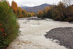
The Province of Pavia is in the region of Lombardy in northwestern Italy. It is bounded to the north by the provinces of Milan and Lodi, to the southeast by the Province of Piacenza (Emilia-Romagna), and to the southwest it is bounded by the Province of Alessandria (Piedmont). The province is crossed by the rivers Ticino and Po, which meet four kilometres south of the capital, Pavia. The province contains 190 communes and the River Po is navigable up to its confluence with the Ticino. [5] There are three regions of the province, the Pavese, which is entirely in the Po Valley, the Lomellina, which is also completely in the Po Valley but between the Ticino and the Po, and Oltrepò, to the south of the Po and which includes Monte Lesima (1,724 m (5,656 ft)), a mountain in the Apennine Mountains which is the highest point in the province. The territory of Siccomario, at the confluence of the two great rivers, should properly be included in Lomellina, but for historical reasons it is considered part of Pavese. Another large river flowing through the province is the Olona. [6]

The province is mostly flat with the northwestern part of the province being good agricultural land. The southern part rises to low hills which give way to the Ligurian Apennines. The town of Pavia has a major position in northern Italy's textile industry and is renowned for hatmaking. It also plays its part in the country's engineering and metallurgical industries. [7] This is an important winemaking district and produces sparkling wines. It is the largest area in Italy for the production of Pinot noir. [8]

Municipalities

Map of the province of Pavia Map of province of Pavia (region Lombardy, Italy).svg
Map of the province of Pavia
Map of the municipalities of the province of Pavia Provincia di pavia.gif
Map of the municipalities of the province of Pavia
Historical population
YearPop.±%
1951506,511    
1961518,193+2.3%
1971526,389+1.6%
1981512,895−2.6%
1991490,898−4.3%
2001493,753+0.6%
2011535,822+8.5%
2021534,506−0.2%
Source: ISTAT

The list below shows the most populated comuni (municipalities) of the province in 2010: [9] Here is a list of the most populated municipalities of the province.

The Certosa di Pavia Monastery Certosa di Pavia - facciata -.jpg
The Certosa di Pavia Monastery
The greenhouse of Belgioioso Castle, projected by Leopoldo Pollack Le serre del Pollack a Belgioioso.JPG
The greenhouse of Belgioioso Castle, projected by Leopoldo Pollack
River Staffora in Oltrepo Pavese TorrenteStaffora Varzi.jpg
River Staffora in Oltrepò Pavese
Bobbio Abbey in Oltrepo Pavese Abbazia di Bobbio.jpg
Bobbio Abbey in Oltrepò Pavese
The lake of Sartirana Lomellina in Lomellina Lago di Sartirana Lomellina, Pavia, Italy - Il canneto.jpg
The lake of Sartirana Lomellina in Lomellina
Po river near Balossa Bigli, a hamlet of Mezzana Bigli, in Lomellina Fiume Po a Balossa Bigli, Pavia, Italy.jpg
Po river near Balossa Bigli, a hamlet of Mezzana Bigli, in Lomellina
Pavia Palazzo Broletto 03.JPG
Pavia
Ponte Coperto and river Ticino in Pavia 20160807-Pavia-002.jpg
Ponte Coperto and river Ticino in Pavia
Vigevano Vigevano0001.jpg
Vigevano
Voghera Voghera duomo.jpg
Voghera
Mortara Mortara duomo.jpg
Mortara
RankCityPopulationArea
(km2)
Density
(inhabitants/km2)
Altitude
(mslm)
1st Pavia 71,142621147.577
2nd Vigevano 63,98482780.3116
3rd Voghera 39,93763.28631.196
4th Mortara 15,67352301.4108
5th Stradella 11,67418.77621.9101
6th Gambolò 10,31251202.2104
7th Garlasco 9,88839.03253.393
8th Broni 9,52820.87456.588
9th Casorate Primo 8,4259936.1103
10th Cassolnovo 7,11631.96222.7120

The full list is:

Territories

The province is mainly divided into 3 geographical regions:

TerritoryArea (km²)PopulationSeatComuniMap
Lomellina
1,097
214,494
58
Lomellina.GIF
Oltrepò Pavese
1,240
146,579
78
Oltrepo pavese.GIF
Pavese
650
189,394
52
Pavese.GIF

Transport

Autostrada A7 near Gropello Cairoli Autogrill Dorno - vista su A7.jpg
Autostrada A7 near Gropello Cairoli

Motorways

Railway lines

References

  1. Italian Institute of Statistics (Istat) (2001). "Superficie territoriale (Kmq) - Pavia (dettaglio comunale) - Censimento 2001" . Retrieved 26 October 2009.
  2. "Popolazione residente al 1° gennaio". Istat. Archived from the original on 15 November 2016. Retrieved 18 August 2015.
  3. Regions and Cities > Regional Statistics > Regional Economy > Regional Gross Domestic Product (Small regions TL3), OECD.Stats. Accessed on 16 November 2018.
  4. "Provincia di Pavia". Tutt Italia. Retrieved 17 August 2015.
  5. 1 2 3 Roy Palmer Domenico (2002). The Regions of Italy: A Reference Guide to History and Culture. Greenwood Publishing Group. p. 200. ISBN   978-0-313-30733-1.
  6. The Times Comprehensive Atlas of the World (13 ed.). Times Books. 2011. p. 76. ISBN   9780007419135.
  7. Russell King (27 March 2015). The Industrial Geography of Italy. Routledge. pp. 185–. ISBN   978-1-317-52111-2.
  8. "Pinot Noir". Mondo del vino al bivio, il Consorzio: Noi parliamo con i fatti. Archived from the original on 8 March 2015. Retrieved 20 August 2015.
  9. "Bilancio demografico anno 2010 e popolazione residente al 31 Dicembre". Istat.it. Retrieved 24 August 2015.

45°11′N9°9′E / 45.183°N 9.150°E / 45.183; 9.150