The province of Sondrio (Italian: provincia di Sondrio), also known as Valtellina (the major valley of the province) is a province in the Lombardy region of Italy. Its provincial capital is the city of Sondrio.
After the fall of the Western Roman Empire, it came under the control of the Lombards and was first ruled by feudal lords from the local area.[3] During the Middle Ages it belonged to the Kingdom of Italy. In the 14th century it fell under the rule of the Duchy of Milan due to the House of Visconti and House of Sforza. Sondrio and Valtellina were strategically important in the politics of Europe, especially in the sixteenth and 17th century religious wars, due to their connections to Europe by Sondrio's Spluga Pass and valleys. Upon the collapse of the Duchy of Milan, rule over Sondrio was exercised by the Swiss Canton of Graubünden. In the Valtellina War, Valtellina was invaded in 1622 by the Spanish Governor of Milan as the valleys had been used to transport troops around Europe; the Spanish efforts were assisted by a 1620 religious revolt in Valtellina against the Swiss.[3]
The Peace of Westphalia (1648) secured peace in the region and granted the region to the Canton of Graubünden. In 1797, the Republic of Valtellina was formed but was quickly conquered by the French to become a component of the Cisalpine Republic client state. The Congress of Vienna (1815) Sondrio and Valtellina as a province of the Austrian Kingdom of Lombardy–Venetia. As most of Lombardy region was absorbed into Kingdom of Sardinia in 1860, Sondrio and Valtellina were also absorbed into Sardinia.[3]
Geography
Di Pian di Gembro natural reserve
The province of Sondrio is a mostly mountainous, sparsely populated area in the north of Lombardy. It borders on the Swiss Canton of Graubünden to the north, the provinces of Como and Lecco to the west, the province of Bergamo to the south and the provinces of Brescia, Trento and Bolzano to the east. The Rhaetian Alps are the highest mountains in Lombardy. The valleys mostly run from north to south, the main ones being the Valtellina and Valchiavenna. One of the main comuni (municipalities) is Livigno (1,800m above sea level), which is a tourist centre in the summer and a ski resort in the winter. There are 78 comuni in the province, and Sondrio is the biggest town and the administrative centre. The Stelvio National Park is located in the north-eastern end of the province.[4]
The economy is based on construction, logging, quarrying, tourism and light industry. Workers from Switzerland commute to work in Sondrio, and other workers cross the border from Italy to join the Swiss workforce.[5] Throughout the province grapes have traditionally been grown, each district having its own local variety and producing its own local wine. It has been necessary for farmers to engineer terraces on the steep slopes, building dry stone retaining walls and moving earth to make the best use of terrain that is unsuitable for general agricultural purposes. The traditions of viticulture are embedded in the culture of the countryside.
Municipalities
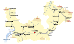
Map of the province of Sondrio
Here is a list of the most populated municipalities of the province.
1 2 3 Roy Palmer Domenico (2002). The Regions of Italy: A Reference Guide to History and Culture. Greenwood Publishing Group. pp.201–202. ISBN978-0-313-30733-1.
This page is based on this Wikipedia article Text is available under the CC BY-SA 4.0 license; additional terms may apply. Images, videos and audio are available under their respective licenses.