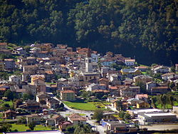
Albosaggia is a comune (municipality) in the Province of Sondrio in the Italian region Lombardy, located about 90 kilometres (56 mi) northeast of Milan and about 2 kilometres (1 mi) southwest of Sondrio. As of 31 December 2004, it had a population of 3,135 and an area of 34.3 square kilometres (13.2 sq mi).
Andalo Valtellino is a comune (municipality) in the Province of Sondrio in the Italian region of Lombardy, located about 80 kilometres (50 mi) northeast of Milan and about 30 kilometres (19 mi) west of Sondrio.
Bema is a comune (municipality) in the Province of Sondrio in the Italian region of Lombardy, located about 80 kilometres (50 mi) northeast of Milan and about 25 kilometres (16 mi) west of Sondrio.

Berbenno di Valtellina is a comune (municipality) in the Province of Sondrio in the Italian region Lombardy, located about 90 kilometres (56 mi) northeast of Milan and about 9 kilometres (6 mi) west of Sondrio. As of 31 December 2004, it had a population of 4,226 and an area of 35.7 square kilometres (13.8 sq mi).
Castione Andevenno is a comune (municipality) in the Province of Sondrio in the Italian region Lombardy, located about 90 kilometres (56 mi) northeast of Milan and about 5 kilometres (3 mi) west of Sondrio. As of 31 December 2004, it had a population of 1,545 and an area of 17.1 square kilometres (6.6 sq mi).

Cercino is a comune (municipality) in the Province of Sondrio in the Italian region of Lombardy, located about 80 kilometres (50 mi) northeast of Milan and about 30 kilometres (19 mi) west of Sondrio. As of 30 November 2014, it had a population of 786 and an area of 6.2 square kilometres (2.4 sq mi).
Chiuro is a comune (municipality) in the Province of Sondrio in the Italian region of Lombardy, located about 100 kilometres (62 mi) northeast of Milan and about 9 kilometres (6 mi) east of Sondrio, on the border with Switzerland. As of 31 December 2004, it had a population of 2,499 and an area of 51.8 square kilometres (20.0 sq mi).

Colorina is a comune (municipality) in the Province of Sondrio in the Italian region Lombardy, located about 90 kilometres (56 mi) northeast of Milan and about 10 kilometres (6 mi) west of Sondrio. As of 31 December 2004, it had a population of 1,468 and an area of 18.0 square kilometres (6.9 sq mi).

Cosio Valtellino is a comune (municipality) in the Province of Sondrio in the Italian region Lombardy, located about 80 kilometres (50 mi) northeast of Milan and about 25 kilometres (16 mi) west of Sondrio.

Delebio is a comune (municipality) in the Province of Sondrio in the Italian region of Lombardy, located about 80 kilometres (50 mi) northeast of Milan and about 30 kilometres (19 mi) west of Sondrio.
Dubino is a comune (municipality) in the Province of Sondrio in the Italian region of Lombardy, located about 80 kilometres (50 mi) northeast of Milan and about 30 kilometres (19 mi) west of Sondrio. As of 31 December 2004, it had a population of 3,270 and an area of 13.1 square kilometres (5.1 sq mi).
Faedo Valtellino is a comune (municipality) in the Province of Sondrio in the Italian region Lombardy, located about 90 kilometres (56 mi) northeast of Milan and about 3 kilometres (2 mi) southeast of Sondrio.

Gordona is a comune (municipality) in the Province of Sondrio in the Italian region Lombardy, located about 90 kilometres (56 mi) north of Milan and about 40 kilometres (25 mi) northwest of Sondrio, on the border with Switzerland. As of 31 December 2004, it had a population of 1,770 and an area of 49.0 square kilometres (18.9 sq mi).
Mantello is a comune (municipality) in the Province of Sondrio in the Italian region of Lombardy, located about 80 kilometres (50 mi) northeast of Milan and about 30 kilometres (19 mi) west of Sondrio. As of 31 December 2004, it had a population of 704 and an area of 3.7 square kilometres (1.4 sq mi).

Pedesina is a comune (municipality) in the Province of Sondrio in the Italian region Lombardy, located about 120 kilometres (75 mi) northeast of Milan and about 40 kilometres (25 mi) southwest of Sondrio. As of 31 December 2008, it had a population of 33, and an area of 6.3 square kilometres (2.4 sq mi). Pedesina borders the following municipalities: Bema, Gerola Alta, Premana, Rasura, Rogolo. It is one of the least populated municipalities in Italy, along with Morterone.
Piateda is a comune (municipality) in the Province of Sondrio in the Italian region Lombardy, located about 100 kilometres (62 mi) northeast of Milan and about 5 kilometres (3 mi) east of Sondrio. As of 31 December 2004, it had a population of 2,291 and an area of 70.9 square kilometres (27.4 sq mi).
Rasura is a comune (municipality) in the Province of Sondrio in the Italian region of Lombardy, located about 80 kilometres (50 mi) northeast of Milan and about 25 kilometres (16 mi) southwest of Sondrio. As of 31 December 2004, it had a population of 297 and an area of 5.5 square kilometres (2.1 sq mi).
Spriana is a comune (municipality) in the Province of Sondrio in the Italian region Lombardy, located about 100 kilometres (62 mi) northeast of Milan and about 6 kilometres (4 mi) north of Sondrio. As of 31 December 2004, it had a population of 101 and an area of 8.2 square kilometres (3.2 sq mi).
Tovo di Sant'Agata is a comune (municipality) in the Province of Sondrio in the Italian region Lombardy, located about 120 kilometres (75 mi) northeast of Milan and about 30 kilometres (19 mi) northeast of Sondrio. As of 31 December 2004, it had a population of 577 and an area of 11.0 square kilometres (4.2 sq mi).

Traona is a comune (municipality) in the Province of Sondrio in the Italian region Lombardy, located about 80 kilometres (50 mi) northeast of Milan and about 25 kilometres (16 mi) west of Sondrio. As of 31 December 2004, it had a population of 2,314 and an area of 6.2 square kilometres (2.4 sq mi).