Poggiridenti

Last updated
Poggiridenti
Comune
Comune di Poggiridenti
Italy provincial location map 2015.svg
Red pog.svg
Poggiridenti
Location of Poggiridenti in Italy
Coordinates: 46°10′N9°55′E / 46.167°N 9.917°E / 46.167; 9.917 Coordinates: 46°10′N9°55′E / 46.167°N 9.917°E / 46.167; 9.917
Country Italy
Region Lombardy
Province Province of Sondrio (SO)
Area
  Total 2.9 km2 (1.1 sq mi)
Elevation 564 m (1,850 ft)
Population (Dec. 2013)
  Total 1,895
  Density 650/km2 (1,700/sq mi)
Time zone CET (UTC+1)
  Summer (DST) CEST (UTC+2)
Postal code23020
Dialing code 0342
Website Official website
Poggiridenti with the view of the Parish Church Panorama Poggiridenti.JPG
Poggiridenti with the view of the Parish Church

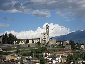
Poggiridenti is a comune (municipality) in the Province of Sondrio in the Italian region Lombardy, located about 100 kilometres (62 mi) northeast of Milan and about 4 kilometres (2 mi) east of Sondrio. As of 31 December 2013, it had a population of 1,895 and an area of 2.9 square kilometres (1.1 sq mi). [1]

<i>Comune</i> third-level administrative divisions of the Italian Republic

The comune is a basic administrative division in Italy, roughly equivalent to a township or municipality.

Province of Sondrio Province of Italy

The Province of Sondrio is in the Lombardy region of northern Italy. Its provincial capital is the town Sondrio. As of 2017, it has a population of 181,403.

Italy republic in Southern Europe

Italy, officially the Italian Republic, is a European country consisting of a peninsula delimited by the Italian Alps and surrounded by several islands. Located in the middle of the Mediterranean sea and traversed along its length by the Apennines, Italy has a largely temperate seasonal climate. The country covers an area of 301,340 km2 (116,350 sq mi) and shares open land borders with France, Slovenia, Austria, Switzerland and the enclaved microstates of Vatican City and San Marino. Italy has a territorial exclave in Switzerland (Campione) and a maritime exclave in the Tunisian sea (Lampedusa). With around 60 million inhabitants, Italy is the fourth-most populous member state of the European Union.

Contents

Poggiridenti borders the following municipalities: Montagna in Valtellina, Piateda, Tresivio.

Montagna in Valtellina Comune in Lombardy, Italy

Montagna in Valtellina is a comune (municipality) in the Province of Sondrio in the Italian region Lombardy, located about 100 kilometres (62 mi) northeast of Milan and about 3 kilometres (2 mi) northeast of Sondrio.

Piateda Comune in Lombardy, Italy

Piateda is a comune (municipality) in the Province of Sondrio in the Italian region Lombardy, located about 100 kilometres (62 mi) northeast of Milan and about 5 kilometres (3 mi) east of Sondrio. As of 31 December 2004, it had a population of 2,291 and an area of 70.9 square kilometres (27.4 sq mi).

Tresivio Comune in Lombardy, Italy

Tresivio is a comune (municipality) in the Province of Sondrio in the Italian region Lombardy, located about 100 kilometres (62 mi) northeast of Milan and about 6 kilometres (4 mi) east of Sondrio. As of 31 December 2004, it had a population of 2,000 and an area of 15.0 square kilometres (5.8 sq mi).

The church of San Fedele has frescoes by Fermo Stella.

San Fedele is a Roman Catholic church located on in the town of Poggiridenti in the province of Sondrio, region of Lombardy, Italy.

Fermo Stella Italian painter

Fermo Stella was an Italian painter of Lombardy and Piedmont, mostly in rural churches and sanctuaries. Art historians from the 19th century cite erroneously Fermo as active at dates that range from the 15th century to l577.

Demographic evolution

Poggiridenti

Related Research Articles

Albosaggia Comune in Lombardy, Italy

Albosaggia is a comune (municipality) in the Province of Sondrio in the Italian region Lombardy, located about 90 kilometres (56 mi) northeast of Milan and about 2 kilometres (1 mi) southwest of Sondrio. As of 31 December 2004, it had a population of 3,135 and an area of 34.3 square kilometres (13.2 sq mi).

Andalo Valtellino Comune in Lombardy, Italy

Andalo Valtellino is a comune (municipality) in the Province of Sondrio in the Italian region Lombardy, located about 80 kilometres (50 mi) northeast of Milan and about 30 kilometres (19 mi) west of Sondrio.

Berbenno di Valtellina Comune in Lombardy, Italy

Berbenno di Valtellina is a comune (municipality) in the Province of Sondrio in the Italian region Lombardy, located about 90 kilometres (56 mi) northeast of Milan and about 9 kilometres (6 mi) west of Sondrio. As of 31 December 2004, it had a population of 4,226 and an area of 35.7 square kilometres (13.8 sq mi).

Buglio in Monte Comune in Lombardy, Italy

Buglio in Monte is a comune (municipality) in the Province of Sondrio in the Italian region Lombardy, located about 90 kilometres (56 mi) northeast of Milan and about 14 kilometres (9 mi) west of Sondrio. As of 31 December 2004, it had a population of 2,066 and an area of 27.8 square kilometres (10.7 sq mi).

Caiolo Comune in Lombardy, Italy

Caiolo is a comune (municipality) in the Province of Sondrio in the Italian region Lombardy, located about 90 kilometres (56 mi) northeast of Milan and about 5 kilometres (3 mi) southwest of Sondrio. As of 31 December 2004, it had a population of 994 and an area of 33.3 square kilometres (12.9 sq mi).

Castello dellAcqua Comune in Lombardy, Italy

Castello dell'Acqua is a comune (municipality) in the Province of Sondrio in the Italian region Lombardy, located about 100 kilometres (62 mi) northeast of Milan and about 12 kilometres (7 mi) east of Sondrio. As of 31 December 2004, it had a population of 693 and an area of 13.9 square kilometres (5.4 sq mi).

Cedrasco Comune in Lombardy, Italy

Cedrasco is a comune (municipality) in the Province of Sondrio in the Italian region Lombardy, located about 90 kilometres (56 mi) northeast of Milan and about 8 kilometres (5 mi) west of Sondrio. As of 31 December 2004, it had a population of 476 and an area of 14.8 square kilometres (5.7 sq mi).

Cosio Valtellino Comune in Lombardy, Italy

Cosio Valtellino is a comune (municipality) in the Province of Sondrio in the Italian region Lombardy, located about 80 kilometres (50 mi) northeast of Milan and about 25 kilometres (16 mi) west of Sondrio.

Faedo Valtellino Comune in Lombardy, Italy

Faedo Valtellino is a comune (municipality) in the Province of Sondrio in the Italian region Lombardy, located about 90 kilometres (56 mi) northeast of Milan and about 3 kilometres (2 mi) southeast of Sondrio.

Gordona Comune in Lombardy, Italy

Gordona is a comune (municipality) in the Province of Sondrio in the Italian region Lombardy, located about 90 kilometres (56 mi) north of Milan and about 40 kilometres (25 mi) northwest of Sondrio, on the border with Switzerland. As of 31 December 2004, it had a population of 1,770 and an area of 49.0 square kilometres (18.9 sq mi).

Ponte in Valtellina Comune in Lombardy, Italy

Ponte in Valtellina is a comune (municipality) in the Province of Sondrio in the Italian region Lombardy, located about 100 kilometres (62 mi) northeast of Milan and about 9 kilometres (6 mi) east of Sondrio. As of 31 December 2004, it had a population of 2,222 and an area of 69.5 square kilometres (26.8 sq mi).

Postalesio Comune in Lombardy, Italy

Postalesio is a comune (municipality) in the Province of Sondrio in the Italian region Lombardy, located about 90 kilometres (56 mi) northeast of Milan and about 6 kilometres (4 mi) west of Sondrio. As of 31 December 2004, it had a population of 618 and an area of 10.6 square kilometres (4.1 sq mi).

Prata Camportaccio Comune in Lombardy, Italy

Prata Camportaccio is a comune (municipality) in the Province of Sondrio in the Italian region Lombardy, located about 100 kilometres (62 mi) north of Milan and about 40 kilometres (25 mi) northwest of Sondrio. As of 31 December 2004, it had a population of 2,758 and an area of 27.9 square kilometres (10.8 sq mi).

Spriana Comune in Lombardy, Italy

Spriana is a comune (municipality) in the Province of Sondrio in the Italian region Lombardy, located about 100 kilometres (62 mi) northeast of Milan and about 6 kilometres (4 mi) north of Sondrio. As of 31 December 2004, it had a population of 101 and an area of 8.2 square kilometres (3.2 sq mi).

Talamona Comune in Lombardy, Italy

Talamona is a comune (municipality) in the Province of Sondrio in the Italian region Lombardy, located about 80 kilometres (50 mi) northeast of Milan and about 20 kilometres (12 mi) west of Sondrio. As of 31 December 2004, it had a population of 4,623 and an area of 21.2 square kilometres (8.2 sq mi).

Traona Comune in Lombardy, Italy

Traona is a comune (municipality) in the Province of Sondrio in the Italian region Lombardy, located about 80 kilometres (50 mi) northeast of Milan and about 25 kilometres (16 mi) west of Sondrio. As of 31 December 2004, it had a population of 2,314 and an area of 6.2 square kilometres (2.4 sq mi).

Verceia Comune in Lombardy, Italy

Verceia is a comune (municipality) in the Province of Sondrio in the Italian region Lombardy, located about 80 kilometres (50 mi) northeast of Milan and about 30 kilometres (19 mi) west of Sondrio. As of 31 December 2004, it had a population of 1,101 and an area of 11.2 square kilometres (4.3 sq mi).

References

  1. All demographics and other statistics: Italian statistical institute Istat.