
Agliè is a comune (municipality) in the Metropolitan City of Turin in the Italian region Piedmont, located about 35 kilometres (22 mi) north of Turin.

Valsolda is a comune (municipality) of about 1,400 inhabitants in the Province of Como in the Italian region Lombardy on the border with Switzerland. It is located about 60 kilometres (37 mi) north of Milan, about 25 kilometres (16 mi) north of Como and 2 kilometres (1.2 mi) east of Lugano.
Bianzone is a comune (municipality) in the Province of Sondrio in the Italian region Lombardy, located about 110 kilometres (68 mi) northeast of Milan and about 20 kilometres (12 mi) east of Sondrio, on the border with Switzerland. As of 31 December 2004, it had a population of 1,250 and an area of 17.3 square kilometres (6.7 sq mi).

Castello dell'Acqua is a comune (municipality) in the Province of Sondrio in the Italian region Lombardy, located about 100 kilometres (62 mi) northeast of Milan and about 12 kilometres (7 mi) east of Sondrio. As of 31 December 2004, it had a population of 693 and an area of 13.9 square kilometres (5.4 sq mi).
Castione Andevenno is a comune (municipality) in the Province of Sondrio in the Italian region Lombardy, located about 90 kilometres (56 mi) northeast of Milan and about 5 kilometres (3 mi) west of Sondrio. As of 31 December 2004, it had a population of 1,545 and an area of 17.1 square kilometres (6.6 sq mi).

Chiesa in Valmalenco is a comune (municipality) in the Province of Sondrio in the Italian region Lombardy, located about 100 kilometres (62 mi) northeast of Milan and about 11 kilometres (7 mi) north of Sondrio, on the border with Switzerland. The English for "Chiesa in Valmalenco" is "Church in Valmalenco": it is the most important village of the Valmalenco valley . "Valmalenco" is a name of unsure origin. Local culture believes it originates from Celtic and Pre-Roman civilisations which share similar meanings: Celtic "Mal en ga", meaning “head pressed by water” and Pre-Roman "Mall-anko" which translates to Mountain river. The area near Chiesa in Valmalenco is famous for alpine skiing and the particular geology of the surrounding mountains. As of 31 December 2004, it had a population of 2,714 and an area of 114.8 square kilometres (44.3 sq mi).
Chiuro is a comune (municipality) in the Province of Sondrio in the Italian region of Lombardy, located about 100 kilometres (62 mi) northeast of Milan and about 9 kilometres (6 mi) east of Sondrio, on the border with Switzerland. As of 31 December 2004, it had a population of 2,499 and an area of 51.8 square kilometres (20.0 sq mi).
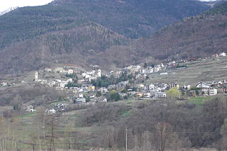
Grosotto is a comune (municipality) in the Province of Sondrio in the Italian region Lombardy, located about 120 kilometres (75 mi) northeast of Milan and about 35 kilometres (22 mi) northeast of Sondrio, on the border with Switzerland.
Mazzo di Valtellina flag.svg
Novate Mezzola is a comune (municipality) in the Province of Sondrio in the Italian region Lombardy, located about 90 kilometres (56 mi) north of Milan and about 35 kilometres (22 mi) west of Sondrio, on the border with Switzerland. As of 31 December 2004, it had a population of 1,713 and an area of 99.7 square kilometres (38.5 sq mi).

Sondalo is a comune (municipality) in the Province of Sondrio in the Italian region Lombardy, located about 130 kilometres (81 mi) northeast of Milan and about 40 kilometres (25 mi) northeast of Sondrio.

Valdidentro is a comune (municipality) in the Province of Sondrio in the Italian region Lombardy, located about 140 kilometres (87 mi) northeast of Milan and about 50 kilometres (31 mi) northeast of Sondrio, in the upper Alta Valtellina on the border with Switzerland.

Valdisotto is a comune (municipality) in the Province of Sondrio in the Italian region of Lombardy, located about 140 kilometres (87 mi) northeast of Milan and about 45 kilometres (28 mi) northeast of Sondrio.

Villa di Chiavenna is a comune (municipality) in the province of Sondrio, in the Italian region of Lombardy, located about 100 kilometres (62 mi) north of Milan and about 35 kilometres (22 mi) northwest of Sondrio, on the border with Switzerland.
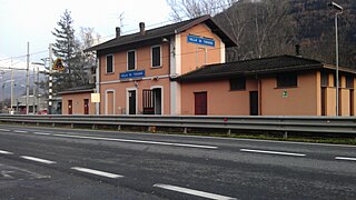
Villa di Tirano is a comune (municipality) in the Province of Sondrio in the Italian region Lombardy, located about 110 kilometres (68 mi) northeast of Milan and about 20 kilometres (12 mi) east of Sondrio, on the border with Switzerland. As of 31 December 2004, it had a population of 2,997 and an area of 24.6 square kilometres (9.5 sq mi).

Almenno San Salvatore is a comune (municipality) in the Province of Bergamo in the Italian region Lombardy, located about 45 kilometres (28 mi) northeast of Milan and about 9 kilometres (6 mi) northwest of Bergamo.

Carobbio degli Angeli is a comune (municipality) in the Province of Bergamo in the Italian region of Lombardy, located about 60 kilometres (37 mi) northeast of Milan and about 13 kilometres (8 mi) southeast of Bergamo.
Fiorano Modenese is a comune (municipality) in the province of Modena in the Italian region Emilia-Romagna, located about 45 kilometres (28 mi) west of Bologna and about 15 kilometres (9 mi) southwest of Modena. Neighboring municipalities are Formigine, Sassuolo, Serramazzoni, Maranello.

Molteno is a comune (municipality) and a hill-top town in the Province of Lecco in the Italian region Lombardy, located about 35 kilometres (22 mi) northeast of Milan and about 11 kilometres (7 mi) southwest of Lecco. As of 31 December 2004, it had a population of 3,206 and an area of 3.2 square kilometres (1.2 sq mi).

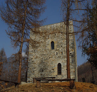
The Rock Engraving Park is an Archaeological Park situated in Grosio and Grosotto, two villages in the valley Valtellina in Lombardy, northern Italy. The park was founded in 1978 to conserve, study and develop the Cultural Heritage on the Dosso dei Castelli.


