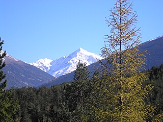
Albosaggia is a comune (municipality) in the Province of Sondrio in the Italian region Lombardy, located about 90 kilometres (56 mi) northeast of Milan and about 2 kilometres (1 mi) southwest of Sondrio. As of 31 December 2004, it had a population of 3,135 and an area of 34.3 square kilometres (13.2 sq mi).

Buglio in Monte is a comune (municipality) in the Province of Sondrio in the Italian region Lombardy, located about 90 kilometres (56 mi) northeast of Milan and about 14 kilometres (9 mi) west of Sondrio. As of 31 December 2004, it had a population of 2,066 and an area of 27.8 square kilometres (10.7 sq mi).

Faedo Valtellino is a comune (municipality) in the Province of Sondrio in the Italian region Lombardy, located about 90 kilometres (56 mi) northeast of Milan and about 3 kilometres (2 mi) southeast of Sondrio.

Lovero is a comune (municipality) in the Province of Sondrio in the Italian region Lombardy, located about 120 kilometres (75 mi) northeast of Milan and about 30 kilometres (19 mi) east of Sondrio. As of 31 December 2004, it had a population of 663 and an area of 13.4 square kilometres (5.2 sq mi).

Montagna in Valtellina is a comune (municipality) in the Province of Sondrio in the Italian region Lombardy, located about 100 kilometres (62 mi) northeast of Milan and about 3 kilometres (2 mi) northeast of Sondrio.

Novate Mezzola is a comune (municipality) in the Province of Sondrio in the Italian region Lombardy, located about 90 kilometres (56 mi) north of Milan and about 35 kilometres (22 mi) west of Sondrio, on the border with Switzerland. As of 31 December 2004, it had a population of 1,713 and an area of 99.7 square kilometres (38.5 sq mi).

Pedesina is a comune (municipality) in the Province of Sondrio in the Italian region Lombardy, located about 70 kilometres (43 mi) northeast of Milan and about 25 kilometres (16 mi) southwest of Sondrio. As of 31 December 2008, it had a population of 33, and an area of 6.3 square kilometres (2.4 sq mi). Pedesina borders the following municipalities: Bema, Gerola Alta, Premana, Rasura, Rogolo. It is the least populated municipality in Italy.

Poggiridenti is a comune (municipality) in the Province of Sondrio in the Italian region Lombardy, located about 100 kilometres (62 mi) northeast of Milan and about 4 kilometres (2 mi) east of Sondrio. As of 31 December 2013, it had a population of 1,895 and an area of 2.9 square kilometres (1.1 sq mi).

Ponte in Valtellina is a comune (municipality) in the Province of Sondrio in the Italian region Lombardy, located about 100 kilometres (62 mi) northeast of Milan and about 9 kilometres (6 mi) east of Sondrio. As of 31 December 2004, it had a population of 2,222 and an area of 69.5 square kilometres (26.8 sq mi).

Prata Camportaccio is a comune (municipality) in the Province of Sondrio in the Italian region Lombardy, located about 100 kilometres (62 mi) north of Milan and about 40 kilometres (25 mi) northwest of Sondrio. As of 31 December 2004, it had a population of 2,758 and an area of 27.9 square kilometres (10.8 sq mi).

Rasura is a comune (municipality) in the Province of Sondrio in the Italian region Lombardy, located about 80 kilometres (50 mi) northeast of Milan and about 25 kilometres (16 mi) southwest of Sondrio. As of 31 December 2004, it had a population of 297 and an area of 5.5 square kilometres (2.1 sq mi).

Spriana is a comune (municipality) in the Province of Sondrio in the Italian region Lombardy, located about 100 kilometres (62 mi) northeast of Milan and about 6 kilometres (4 mi) north of Sondrio. As of 31 December 2004, it had a population of 101 and an area of 8.2 square kilometres (3.2 sq mi).

Talamona is a comune (municipality) in the Province of Sondrio in the Italian region Lombardy, located about 80 kilometres (50 mi) northeast of Milan and about 20 kilometres (12 mi) west of Sondrio. As of 31 December 2004, it had a population of 4,623 and an area of 21.2 square kilometres (8.2 sq mi).

Tovo di Sant'Agata is a comune (municipality) in the Province of Sondrio in the Italian region Lombardy, located about 120 kilometres (75 mi) northeast of Milan and about 30 kilometres (19 mi) northeast of Sondrio. As of 31 December 2004, it had a population of 577 and an area of 11.0 square kilometres (4.2 sq mi).

Tresivio is a comune (municipality) in the Province of Sondrio in the Italian region Lombardy, located about 100 kilometres (62 mi) northeast of Milan and about 6 kilometres (4 mi) east of Sondrio. As of 31 December 2004, it had a population of 2,000 and an area of 15.0 square kilometres (5.8 sq mi).

Valfurva is a comune (municipality) in the Province of Sondrio in the Italian region Lombardy, located about 150 kilometres (93 mi) northeast of Milan and about 50 kilometres (31 mi) northeast of Sondrio, in the Alps. As of 31 December 2004, it had a population of 2,725 and an area of 215.9 square kilometres (83.4 sq mi).

Verceia is a comune (municipality) in the Province of Sondrio in the Italian region Lombardy, located about 80 kilometres (50 mi) northeast of Milan and about 30 kilometres (19 mi) west of Sondrio. As of 31 December 2004, it had a population of 1,101 and an area of 11.2 square kilometres (4.3 sq mi).

Mese is a comune (municipality) in the Province of Sondrio in the Italian region Lombardy, located about 90 kilometres (56 mi) north of Milan and about 40 kilometres (25 mi) northwest of Sondrio. As of 31 December 2004, it had a population of 1,652 and an area of 4.2 square kilometres (1.6 sq mi).


