Cino is a comune in the province of Sondrio in Italy, and it has a population of about 400 inhabitants, with an area of 5 square kilometres (1.9 sq mi), the density is 67 inhabitants/km2. Cino borders the following municipalities: Cercino, Mantello, Novate Mezzola, Dubino.
Livo is a comune (municipality) in the Province of Como in the Italian region Lombardy, located about 80 kilometres (50 mi) north of Milan and about 40 kilometres (25 mi) northeast of Como, on the border with Switzerland. As of 31 December 2004, it had a population of 212 and an area of 32.5 km².
Montemezzo is a comune (municipality) in the Province of Como in the Italian region Lombardy, located about 80 kilometres (50 mi) north of Milan and about 45 kilometres (28 mi) northeast of Como. As of 31 December 2004, it had a population of 270 and an area of 9.1 km2.

Sorico is a comune (municipality) in the Province of Como in the Italian region Lombardy, located about 80 kilometres (50 mi) north of Milan and about 45 kilometres (28 mi) northeast of Como. As of 31 December 2004, it had a population of 1,188 and an area of 23.3 square kilometres (9.0 sq mi).
Vercana is a comune (municipality) in the Province of Como in the Italian region Lombardy, located about 80 kilometres (50 mi) north of Milan and about 45 kilometres (28 mi) northeast of Como. As of 31 December 2004, it had a population of 729 and an area of 14.6 square kilometres (5.6 sq mi).

Campodolcino is a comune (municipality) in the Province of Sondrio in the Italian region of Lombardy, located about 100 kilometres (62 mi) north of Milan and about 50 kilometres (31 mi) northwest of Sondrio, on the border with Switzerland. As of 31 December 2004, it had a population of 1,077 and an area of 48.3 square kilometres (18.6 sq mi).

Cercino is a comune (municipality) in the Province of Sondrio in the Italian region of Lombardy, located about 80 kilometres (50 mi) northeast of Milan and about 30 kilometres (19 mi) west of Sondrio. As of 30 November 2014, it had a population of 786 and an area of 6.2 square kilometres (2.4 sq mi).

Chiesa in Valmalenco is a comune (municipality) in the Province of Sondrio in the Italian region Lombardy, located about 100 kilometres (62 mi) northeast of Milan and about 11 kilometres (7 mi) north of Sondrio, on the border with Switzerland. The English for "Chiesa in Valmalenco" is "Church in Valmalenco": it is the most important village of the Valmalenco valley . "Valmalenco" is a name of unsure origin. Local culture believes it originates from Celtic and Pre-Roman civilisations which share similar meanings: Celtic "Mal en ga", meaning “head pressed by water” and Pre-Roman "Mall-anko" which translates to Mountain river. The area near Chiesa in Valmalenco is famous for alpine skiing and the particular geology of the surrounding mountains. As of 31 December 2004, it had a population of 2,714 and an area of 114.8 square kilometres (44.3 sq mi).
Dubino is a comune (municipality) in the Province of Sondrio in the Italian region of Lombardy, located about 80 kilometres (50 mi) northeast of Milan and about 30 kilometres (19 mi) west of Sondrio. As of 31 December 2004, it had a population of 3,270 and an area of 13.1 square kilometres (5.1 sq mi).

Gordona is a comune (municipality) in the Province of Sondrio in the Italian region Lombardy, located about 90 kilometres (56 mi) north of Milan and about 40 kilometres (25 mi) northwest of Sondrio, on the border with Switzerland. As of 31 December 2004, it had a population of 1,770 and an area of 49.0 square kilometres (18.9 sq mi).
Novate Mezzola is a comune (municipality) in the Province of Sondrio in the Italian region Lombardy, located about 90 kilometres (56 mi) north of Milan and about 35 kilometres (22 mi) west of Sondrio, on the border with Switzerland. As of 31 December 2004, it had a population of 1,713 and an area of 99.7 square kilometres (38.5 sq mi).
Piuro is a comune (municipality) in the Province of Sondrio in the Italian region Lombardy, located about 100 kilometres (62 mi) north of Milan and about 40 kilometres (25 mi) northwest of Sondrio, on the border with Switzerland. As of 31 December 2004, it had a population of 1,938 and an area of 85.4 square kilometres (33.0 sq mi).
Prata Camportaccio is a comune (municipality) in the Province of Sondrio in the Italian region Lombardy, located about 100 kilometres (62 mi) north of Milan and about 40 kilometres (25 mi) northwest of Sondrio. As of 31 December 2004, it had a population of 2,758 and an area of 27.9 square kilometres (10.8 sq mi).
Spriana is a comune (municipality) in the Province of Sondrio in the Italian region Lombardy, located about 100 kilometres (62 mi) northeast of Milan and about 6 kilometres (4 mi) north of Sondrio. As of 31 December 2004, it had a population of 101 and an area of 8.2 square kilometres (3.2 sq mi).

Torre di Santa Maria is a comune (municipality) in the Province of Sondrio in the Italian region Lombardy, located about 100 kilometres (62 mi) northeast of Milan and about 8 kilometres (5 mi) north of Sondrio. As of 31 December 2004, it had a population of 884 and an area of 45.5 square kilometres (17.6 sq mi).

Traona is a comune (municipality) in the Province of Sondrio in the Italian region Lombardy, located about 80 kilometres (50 mi) northeast of Milan and about 25 kilometres (16 mi) west of Sondrio. As of 31 December 2004, it had a population of 2,314 and an area of 6.2 square kilometres (2.4 sq mi).
Val Masino is a comune (municipality) in the Province of Sondrio in the Italian region Lombardy, located about 90 kilometres (56 mi) northeast of Milan and about 20 kilometres (12 mi) northwest of Sondrio, on the border with Switzerland. As of 31 December 2004, it had a population of 962 and an area of 116.0 square kilometres (44.8 sq mi).
Verceia is a comune (municipality) in the Province of Sondrio in the Italian region Lombardy, located about 80 kilometres (50 mi) northeast of Milan and about 30 kilometres (19 mi) west of Sondrio. As of 31 December 2004, it had a population of 1,101 and an area of 11.2 square kilometres (4.3 sq mi).

Villa di Chiavenna is a comune (municipality) in the province of Sondrio, in the Italian region of Lombardy, located about 100 kilometres (62 mi) north of Milan and about 35 kilometres (22 mi) northwest of Sondrio, on the border with Switzerland.

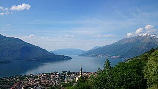
The Valchiavenna is an alpine valley in the province of Sondrio, in Lombardy in northern Italy. It lies to the north of Lake Como, and is traversed by the rivers Mera and Liro. It can be divided into three parts which branch from the confluence of these rivers near Chiavenna, the principal town of the region.


