| Pizzale | |
|---|---|
| Comune | |
| Comune di Pizzale | |
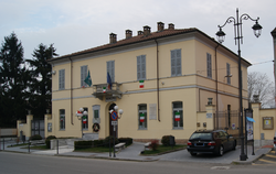
Town hall. | |
 Pizzale Location of Pizzale in Italy | |
| Coordinates: 45°2′N9°3′E / 45.033°N 9.050°E Coordinates: 45°2′N9°3′E / 45.033°N 9.050°E | |
| Country | Italy |
| Region | Lombardy |
| Province | Pavia (PV) |
| Government | |
| • Mayor | Sonia Grazioli |
| Area | |
| • Total | 7.09 km2 (2.74 sq mi) |
| Elevation | 728 m (2,388 ft) |
| Population (31 December 2010) [1] | |
| • Total | 733 |
| • Density | 100/km2 (270/sq mi) |
| Demonym(s) | Pizzalesi |
| Time zone | CET (UTC+1) |
| • Summer (DST) | CEST (UTC+2) |
| Postal code | 27050 |
| Dialing code | 0383 |
| Website | Official website |
Pizzale is a comune (municipality) in the Province of Pavia in the Italian region Lombardy, located about 50 km south of Milan and about 20 km southwest of Pavia.

The comune is a basic administrative division in Italy, roughly equivalent to a township or municipality.
The province of Pavia is a province in the region of Lombardy in northern Italy; its capital is Pavia. As of 2015, the province has a population of 548,722 inhabitants and an area of 2,968.64 square kilometres (1,146.20 sq mi); the town of Pavia has a population of 72,205.

Italy, officially the Italian Republic, is a European country consisting of a peninsula delimited by the Italian Alps and surrounded by several islands. Located in the middle of the Mediterranean sea and traversed along its length by the Apennines, Italy has a largely temperate seasonal climate. The country covers an area of 301,340 km2 (116,350 sq mi) and shares open land borders with France, Slovenia, Austria, Switzerland and the enclaved microstates of Vatican City and San Marino. Italy has a territorial exclave in Switzerland (Campione) and a maritime exclave in the Tunisian sea (Lampedusa). With around 60 million inhabitants, Italy is the fourth-most populous member state of the European Union.
Pizzale borders the following municipalities: Castelletto di Branduzzo, Lungavilla, Pancarana, Voghera.

Castelletto di Branduzzo is a comune (municipality) in the Province of Pavia in the Italian region Lombardy, located about 45 km (28 mi) south of Milan and about 14 km (8.7 mi) southwest of Pavia.

Lungavilla is a comune (municipality) in the Province of Pavia in the Italian region Lombardy, located about 50 km south of Milan and about 15 km southwest of Pavia.
Pancarana is a comune (municipality) in the province of Pavia in the Italian region Lombardy, located about 45 km south of Milan and about 14 km southwest of Pavia, in the Oltrepò Pavese.


