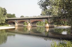
The Oglio (Italian:[ˈɔʎʎo]; Latin: Ollius or Olius; Lombard: Òi, Cremonese: Ùi) is a left-side tributary of the river Po in Lombardy, Italy. It is 280 kilometres (170mi) long. In the hierarchy of the Po's tributaries, with its 280 kilometres (170mi) of length, it occupies the 2nd place per length (after the river Adda), while it is the 4th per basin surface (after Tanaro, Adda and Ticino), and the 3rd per average discharge at the mouth (after Ticino and Adda).
The Oglio is formed from the confluence of two mountain streams, the Narcanello branch from the Presena Glacier, in the Adamello group and the Frigidolfo branch, in the Corno dei Tre Signori, part of the Stelvio National Park. The streams merge near Pezzo di Ponte di Legno, both the streams have an average discharge of 1.5m3/s (53cuft/s). The Frigidolfo branch, before merging with Narcanello branch, receives the Arcanello branch, which have an average discharge of 0.5m3/s (18cuft/s), which receives a minor branch originating from Lake Ercavallo. The Ogliolo stream, with an average discharge of 2.5m3/s (88cuft/s) and a length of 20 kilometres (12mi) (similar to the length of the main branch between the Frigidolfo-Narcanello merge at Ponte Di Legno and the Oglio-Ogliolo merge at Edolo) is sometimes considered as a de facto fourth branch of the Oglio river.[citation needed]
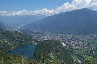
It flows in a southwest direction, through Valcamonica and enters into the Lake Iseo at Costa Volpino. It leaves Lake Iseo at Sarnico and, after traveling a zone of moraine deposits, it joins the Po river at Torredoglio, not far from Cesole and Scorzarolo, in the province of Mantua. Its drainage basin, which corresponds to the region of Valle Camonica, covers 6,649 square kilometres (2,567sqmi). It is part of the larger Po-Adige basin.[citation needed]
The Cisalpine Republic was a sister republic or a client state of France in Northern Italy that existed from 1797 to 1799, with a second version until 1802.
The province of Bergamo is a province in the Lombardy region of Italy. Its capital is the city of Bergamo. The province has a population of 1,103,768 (2023), an area of 2,754.91 square kilometers (1,063.68 sq mi), and contains 242 comuni.
The province of Brescia is a province in the Lombardy region of Italy. It has a population of some 1,265,964 and its capital is the city of Brescia.
The province of Cremona is a province in the Lombardy region of Italy. Its capital city is Cremona.
The province of Mantua is a province in the Lombardy region of Italy. Its capital is the city of Mantua. It is bordered to the north-east by the province of Verona, to the east by the province of Rovigo, to the south by the province of Ferrara, province of Modena, province of Reggio Emilia and province of Parma, to the west by the province of Cremona, and to the north-west by the province of Brescia.
Darfo Boario Terme is a comune in the province of Brescia, in Lombardy, northern Italy. The name combines Darfo, the capoluogo, with Boario Terme, the largest frazione.
Paratico is a town and comune in the province of Brescia, in Lombardy, Italy. It is located at the southwestern end of Lake Iseo.
Lake Iseo or Iseo lake, also known as Sebino, is the fourth largest lake in Lombardy, Italy, fed by the Oglio River.
Ponte di Legno is an Italian comune of 1,729 inhabitants in Val Camonica, province of Brescia, in Lombardy.
Val Camonica or Valcamonica, also Valle Camonica and anglicized as Camonica Valley, is one of the largest valleys of the central Alps, in eastern Lombardy, Italy. It extends about 90 kilometres (56 mi) from the Tonale Pass to Corna Trentapassi, in the commune of Pisogne near Lake Iseo. It has an area of about 1,335 km2 (515 sq mi) and 118,323 inhabitants. The River Oglio runs through its full length, rising at Ponte di Legno and flowing into Lake Iseo between Pisogne and Costa Volpino.
Piadena is a former comune in the Province of Cremona, Italy. On January 1, 2019 it merged with Drizzona to form Piadena Drizzona.
The Battle of Maclodio was fought on 11 October 1427, resulting in a victory for the Venetians under Carmagnola over the Milanese under Carlo I Malatesta. The battle was fought at Maclodio, a small town near the River Oglio, fifteen kilometres south-west of Brescia. This battle, fought during the second campaign, was the only decisive victory for Venice in the Wars in Lombardy. This battle forced the Milanese into a treaty, conceding Brescia in 1428, though fighting of the wars in Lombardy was to resume later, continuing until the Treaty of Lodi in 1454.
Gazoldo degli Ippoliti is a comune (municipality) in the Province of Mantua in the Italian region Lombardy, located about 110 kilometres (68 mi) east of Milan and about 15 kilometres (9 mi) west of Mantua.
Viadana is a comune (municipality) in the Province of Mantua in the Italian region Lombardy, located about 120 kilometres (75 mi) southeast of Milan and about 35 kilometres (22 mi) southwest of Mantua.
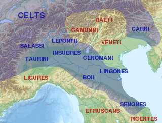
The Cenomani, was an ancient tribe of the Cisalpine Gauls, who occupied the tract north of the Padus, between the Insubres on the west and the Veneti on the east. Their territory appears to have extended from the river Addua to the Athesis.
The rock drawings in Valcamonica are located in the Province of Brescia, Italy, and constitute the largest collections of prehistoric petroglyphs in the world. The collection was recognized by UNESCO in 1979 and was Italy's first recognized World Heritage Site. UNESCO has formally recognized more than 140,000 figures and symbols, but new discoveries have increased the number of catalogued incisions to between 200,000 and 300,000. The petroglyphs are spread on all surfaces of the valley, but concentrated in the areas of Darfo Boario Terme, Capo di Ponte, Nadro, Cimbergo and Paspardo.
Brescia railway station is the main station of Brescia, in the region of Lombardy, northern Italy. The station, opened in 1854, lies on the Milan-Venice railway and is a terminus of three branch lines: Valcamonica Railway to Edolo, Bergamo–Brescia railway and Brescia–Piadena/Cremona railway which branches off towards southeast of the station.
The Frigidolfo is a stream of Val Camonica, in the province of Brescia, about 7 km long.
Upper Mantua is a geographical area located northwest of the city of Mantua in the province of the same name and bordering the provinces of Brescia and Verona, bordered to the north by the morainic hills of Lake Garda, to the east by the province of Verona, to the northwest by the province of Brescia, and to the south by the plains of Middle Mantua.
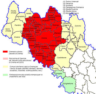
The Cremasque Territory is a geographical area located in the Lombardy, corresponding to the northern part of the Province of Cremona, of which it represents the most industrialized and densely inhabited area. Its main center is the city of Crema and currently constitutes one of the 4 employment districts into which the province of Cremona is divided.
This page is based on this Wikipedia article Text is available under the CC BY-SA 4.0 license; additional terms may apply. Images, videos and audio are available under their respective licenses.