Vilminore di Scalve

Last updated
Vilminore di Scalve
Comune
Comune di Vilminore di Scalve
VilminoreDS panorama 01.JPG
Vilminore di Scalve
Italy provincial location map 2015.svg
Red pog.svg
Vilminore di Scalve
Location of Vilminore di Scalve in Italy
Coordinates: 46°0′N10°6′E / 46.000°N 10.100°E / 46.000; 10.100 Coordinates: 46°0′N10°6′E / 46.000°N 10.100°E / 46.000; 10.100
Country Italy
Region Lombardy
Province Province of Bergamo (BG)
Frazioni Vilmaggiore, S. Andrea, Dezzolo, Bueggio, Nona, Pezzolo, Pianezza, Teveno
Area
  Total 40.9 km2 (15.8 sq mi)
Elevation 1,019 m (3,343 ft)
Population (Dec. 2010)
  Total 1,532
  Density 37/km2 (97/sq mi)
Demonym(s) Vilminoresi
Time zone CET (UTC+1)
  Summer (DST) CEST (UTC+2)
Postal code24020
Dialing code 0346
Website Official website

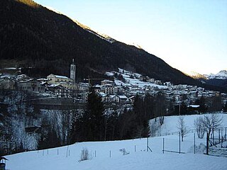
Vilminore di Scalve (Bergamasque: Ilminùr) is a comune (municipality) in the Province of Bergamo in the Italian region of Lombardy, located about 90 kilometres (56 mi) northeast of Milan and about 45 kilometres (28 mi) northeast of Bergamo. As of 31 December 2010, it had a population of 1,532 and an area of 40.9 square kilometres (15.8 sq mi). [1]

<i>Comune</i> third-level administrative divisions of the Italian Republic

The comune is a basic administrative division in Italy, roughly equivalent to a township or municipality.

Province of Bergamo Province of Italy

The Province of Bergamo is a province in the Lombardy region of Italy. It has a population of 1,112,187 (2017), an area of 2,754.91 square kilometers (1,063.68 sq mi), and contains 243 comuni. Its capital is the city of Bergamo.

Italy republic in Southern Europe

Italy, officially the Italian Republic, is a country in Southern Europe. Located in the middle of the Mediterranean Sea, Italy shares open land borders with France, Switzerland, Austria, Slovenia and the enclaved microstates San Marino and Vatican City. Italy covers an area of 301,340 km2 (116,350 sq mi) and has a largely temperate seasonal and Mediterranean climate. With around 61 million inhabitants, it is the fourth-most populous EU member state and the most populous country in Southern Europe.

Contents

The municipality of Vilminore di Scalve contains the frazioni (subdivisions, mainly villages and hamlets) Vilmaggiore, S. Andrea, Dezzolo, Bueggio, Nona, Pezzolo, Pianezza, and Teveno.

"Frazione" is the Italian name given in administrative law to a type of territorial subdivision of a comune; for other administrative divisions, see municipio, circoscrizione, quartiere. It is cognate to the English word fraction, but in practice is roughly equivalent to "parishes" or "wards" in other countries.

Vilminore di Scalve borders the following municipalities: Azzone, Colere, Gromo, Oltressenda Alta, Rovetta, Schilpario, Teglio, Valbondione.

Azzone Comune in Lombardy, Italy

Azzone is a comune (municipality) in the Province of Bergamo in the Italian region of Lombardy, located about 90 kilometres (56 mi) northeast of Milan and about 45 kilometres (28 mi) northeast of Bergamo. As of 31 December 2004, it had a population of 458 and an area of 16.8 square kilometres (6.5 sq mi).

Colere Comune in Lombardy, Italy

Colere is a comune (municipality) in the Province of Bergamo in the Italian region of Lombardy, located about 90 kilometres (56 mi) northeast of Milan and about 45 kilometres (28 mi) northeast of Bergamo. As of 31 December 2004, it had a population of 1,147 and an area of 18.8 square kilometres (7.3 sq mi).

Gromo Comune in Lombardy, Italy

Gromo is a comune (municipality) in the Province of Bergamo in the Italian region of Lombardy, located about 80 kilometres (50 mi) northeast of Milan and about 35 kilometres (22 mi) northeast of Bergamo. As of 31 December 2004, it had a population of 1,246 and an area of 20.0 square kilometres (7.7 sq mi).

Demographic evolution

Vilminore di Scalve

Related Research Articles

Arcene Comune in Lombardy, Italy

Arcene is a comune (municipality) in the Province of Bergamo in the Italian region of Lombardy, located about 35 kilometres (22 mi) northeast of Milan and about 14 kilometres (9 mi) southwest of Bergamo. As of 31 December 2004, it had a population of 4,529 and an area of 4.2 square kilometres (1.6 sq mi).

Aviatico Comune in Lombardy, Italy

Aviatico is a comune (municipality) in the Province of Bergamo in the Italian region of Lombardy, located about 60 kilometres (37 mi) northeast of Milan and about 12 kilometres (7 mi) northeast of Bergamo. As of 31 December 2007, it had a population of 515 and an area of 8.4 square kilometres (3.2 sq mi).

Bracca Comune in Lombardy, Italy

Bracca is a comune (municipality) in the Province of Bergamo in the Italian region of Lombardy, located about 60 kilometres (37 mi) northeast of Milan and about 14 kilometres (9 mi) northeast of Bergamo. As of 31 December 2004, it had a population of 827 and an area of 5.5 square kilometres (2.1 sq mi).

Colzate Comune in Lombardy, Italy

Colzate is a comune (municipality) in the Province of Bergamo in the Italian region of Lombardy, located about 70 kilometres (43 mi) northeast of Milan and about 20 kilometres (12 mi) northeast of Bergamo. As of 31 December 2004, it had a population of 1,638 and an area of 6.7 square kilometres (2.6 sq mi).

Ghisalba Comune in Lombardy, Italy

Ghisalba is a comune (municipality) in the Province of Bergamo in the Italian region of Lombardy, located about 50 kilometres (31 mi) northeast of Milan and about 13 kilometres (8 mi) southeast of Bergamo. As of 31 December 2010, it had a population of 5,967 and an area of 10.2 square kilometres (3.9 sq mi).

Oltressenda Alta Comune in Lombardy, Italy

Oltressenda Alta is a comune (municipality) in the Province of Bergamo in the Italian region of Lombardy, located about 80 kilometres (50 mi) northeast of Milan and about 30 kilometres (19 mi) northeast of Bergamo. As of 31 December 2004, it had a population of 195 and an area of 17.3 square kilometres (6.7 sq mi).

Osio Sotto Comune in Lombardy, Italy

Osio Sotto is a comune (municipality) in the Province of Bergamo in the Italian region of Lombardy, located about 40 kilometres (25 mi) northeast of Milan and about 11 kilometres (7 mi) southwest of Bergamo. As of 31 December 2004, it had a population of 11,097 and an area of 7.5 square kilometres (2.9 sq mi).

Piario Comune in Lombardy, Italy

Piario is a comune (municipality) in the Province of Bergamo in the Italian region of Lombardy, located about 80 kilometres (50 mi) northeast of Milan and about 30 kilometres (19 mi) northeast of Bergamo. As of 31 December 2004, it had a population of 990 and an area of 1.5 square kilometres (0.58 sq mi).

Ranica Comune in Lombardy, Italy

Ranica is a comune (municipality) in the Province of Bergamo in the Italian region of Lombardy, located about 50 kilometres (31 mi) northeast of Milan and about 5 kilometres (3 mi) northeast of Bergamo. As of 31 December 2004, it had a population of 5,984 and an area of 4.2 square kilometres (1.6 sq mi).

Rovetta Comune in Lombardy, Italy

Rovetta is a comune (municipality) in the Province of Bergamo in the Italian region of Lombardy, located about 80 kilometres (50 mi) northeast of Milan and about 30 kilometres (19 mi) northeast of Bergamo. As of 31 December 2004, it had a population of 3,611 and an area of 24.0 square kilometres (9.3 sq mi).

Schilpario Comune in Lombardy, Italy

Schilpario is a comune (municipality) in the Province of Bergamo in the Italian region of Lombardy, located about 100 kilometres (62 mi) northeast of Milan and about 50 kilometres (31 mi) northeast of Bergamo.

Sedrina Comune in Lombardy, Italy

Sedrina is a comune (municipality) in the Province of Bergamo in the Italian region of Lombardy, located about 50 kilometres (31 mi) northeast of Milan and about 10 kilometres (6 mi) northwest of Bergamo. As of 31 December 2010, it had a population of 2,559 and an area of 6.0 square kilometres (2.3 sq mi).

Seriate Comune in Lombardy, Italy

Seriate is a comune (municipality) in the Province of Bergamo in the Italian region of Lombardy, located about 50 kilometres (31 mi) northeast of Milan and about 4 kilometres (2 mi) southeast of Bergamo. As of 31 December 2010, it had a population of 24,297 and an area of 12.4 square kilometres (4.8 sq mi).

Telgate Comune in Lombardy, Italy

Telgate is a comune (municipality) in the Province of Bergamo in the Italian region of Lombardy, located about 60 kilometres (37 mi) northeast of Milan and about 15 kilometres (9 mi) southeast of Bergamo. As of 31 December 2004, it had a population of 4,598 and an area of 8.1 square kilometres (3.1 sq mi).

Valbondione Comune in Lombardy, Italy

Valbondione is a comune (municipality) in the Province of Bergamo in the Italian region of Lombardy, located about 90 kilometres (56 mi) northeast of Milan and about 45 kilometres (28 mi) north of Bergamo. As of 31 December 2004, it had a population of 1,156 and an area of 95.0 square kilometres (36.7 sq mi).

Villa di Serio Comune in Lombardy, Italy

Villa di Serio is a comune (municipality) in the Province of Bergamo in the Italian region of Lombardy, located about 50 kilometres (31 mi) northeast of Milan and about 6 kilometres (4 mi) northeast of Bergamo. As of 31 December 2004, it had a population of 6,118 and an area of 4.6 square kilometres (1.8 sq mi).

Cornalba Comune in Lombardy, Italy

Cornalba is a comune (municipality) in the Province of Bergamo in the Italian region of Lombardy, located about 60 kilometres (37 mi) northeast of Milan and about 20 kilometres (12 mi) northeast of Bergamo. As of 31 December 2010, it had a population of 310 and an area of 9.4 square kilometres (3.6 sq mi).

References

  1. Istat - Resident population as of 31 december 2010.