Treviolo

Last updated
Treviolo
Comune
Comune di Treviolo
Treviolo chiesa parrocchiale.jpg
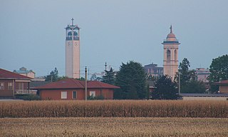
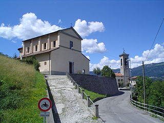
Saint George's church
Italy provincial location map 2015.svg
Red pog.svg
Treviolo
Location of Treviolo in Italy
Coordinates: 45°40′22″N9°35′56″E / 45.67278°N 9.59889°E / 45.67278; 9.59889 Coordinates: 45°40′22″N9°35′56″E / 45.67278°N 9.59889°E / 45.67278; 9.59889
Country Italy
Region Lombardy
Province Province of Bergamo (BG)
Frazioni Curnasco, Albegno, Roncola
Area
  Total 8.7 km2 (3.4 sq mi)
Elevation 225 m (738 ft)
Population (January 2011)
  Total 10,363
  Density 1,200/km2 (3,100/sq mi)
Demonym(s) Treviolesi
Time zone CET (UTC+1)
  Summer (DST) CEST (UTC+2)
Postal code24048
Dialing code 035
Website Official website

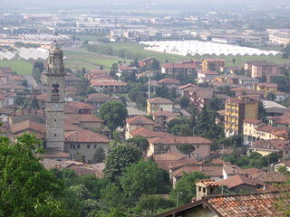
Treviolo (Bergamasque: Treviöl) is a comune (municipality) in the Province of Bergamo in the Italian region of Lombardy, located about 40 kilometres (25 mi) northeast of Milan and about 7 kilometres (4 mi) southwest of Bergamo. As of 1 January 2011, it had a population of 10,363 and an area of 8.7 square kilometres (3.4 sq mi). [1]

<i>Comune</i> third-level administrative divisions of the Italian Republic

The comune is a basic administrative division in Italy, roughly equivalent to a township or municipality.

Province of Bergamo Province of Italy

The Province of Bergamo is a province in the Lombardy region of Italy. It has a population of 1,112,187 (2017), an area of 2,754.91 square kilometers (1,063.68 sq mi), and contains 243 comuni. Its capital is the city of Bergamo.

Italy republic in Southern Europe

Italy, officially the Italian Republic, is a country in Southern and Western Europe. Located in the middle of the Mediterranean Sea, Italy shares open land borders with France, Switzerland, Austria, Slovenia and the enclaved microstates San Marino and Vatican City. Italy covers an area of 301,340 km2 (116,350 sq mi) and has a largely temperate seasonal and Mediterranean climate. With around 61 million inhabitants, it is the fourth-most populous EU member state and the most populous country in Southern Europe.

Contents

The municipality of Treviolo contains the frazioni (subdivisions, mainly villages and hamlets) Curnasco, Albegno, and Roncola: Curnasco is the most populated.

"Frazione" is the Italian name given in administrative law to a type of territorial subdivision of a comune; for other administrative divisions, see municipio, circoscrizione, quartiere. It is cognate to the English word fraction, but in practice is roughly equivalent to "parishes" or "wards" in other countries.

Treviolo borders the following municipalities: Bergamo, Bonate Sopra, Bonate Sotto, Curno, Dalmine, Lallio.

Bergamo Comune in Lombardy, Italy

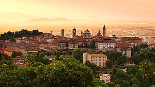
Bergamo is a city in the alpine Lombardy region of northern Italy, approximately 40 km (25 mi) northeast of Milan, and about 30 km (19 mi) from Switzerland, the alpine lakes Como and Iseo and 70 km (43 mi) from Garda and Maggiore. The Bergamo Alps begin immediately north of the city.

Bonate Sopra Comune in Lombardy, Italy

Bonate Sopra is a comune (municipality) in the Province of Bergamo in the Italian region Lombardy, located about 40 kilometres (25 mi) northeast of Milan and about 8 kilometres (5 mi) west of Bergamo. As of 31 December 2004, it had a population of 7,042 and an area of 5.9 square kilometres (2.3 sq mi).

Bonate Sotto Comune in Lombardy, Italy

Bonate Sotto is a comune (municipality) in the Province of Bergamo in the Italian region of Lombardy, located about 40 kilometres (25 mi) northeast of Milan and about 9 kilometres (6 mi) southwest of Bergamo in the Isola bergamasca.

History

The first human settlements in the area were probably the Ligurian tribes, as evidenced by the name "Curnasco", where the suffix "-asco" is a characteristic feature of those populations.

Ligures ethnic group

The Ligures were an Indo-European people who appear to have originated in, and gave their name to, Liguria, a region of north-western Italy. Elements of the Ligures appear to have migrated to other areas of western Europe, including the Iberian peninsula.

In the Roman period, the residential nucleus developed considerably; given the proximity to Bergamo, it is assumed that those settlements were military outposts for the city.[ citation needed ]

Ancient Rome History of Rome from the 8th-century BC to the 5th-century

In historiography, ancient Rome is Roman civilization from the founding of the city of Rome in the 8th century BC to the collapse of the Western Roman Empire in the 5th century AD, encompassing the Roman Kingdom, Roman Republic and Roman Empire until the fall of the western empire. The civilization began as an Italic settlement in the Italian peninsula, dating from the 8th century BC, that grew into the city of Rome and which subsequently gave its name to the empire over which it ruled and to the widespread civilisation the empire developed. The Roman empire expanded to become one of the largest empires in the ancient world, though still ruled from the city, with an estimated 50 to 90 million inhabitants and covering 5.0 million square kilometres at its height in AD 117.

At the end of Roman domination, it is thought that Treviolo, Albegno and Curnasco went through a phase of depopulation, which ended with the arrival of the Lombards, who established Curnasco, cited in documents of the year 774. Of the 871 are the acts which refer to Albineas (later translated as early as 964 in Albigna), while Trevilio appears in papers dating back to 910 (only in 1174 would it appear as Triviliolo).

Lombards Historical ethnical group

The Lombards or Longobards were a Germanic people who ruled most of the Italian Peninsula from 568 to 774.

During this time, the entire area was ruled by the Holy Roman Empire, whose rulers instituted feudalism. Those entrusted to the Bishop of Bergamo territories of Treviolo already in the 12th century,[ clarification needed ] but their proximity to the capital made them particularly vulnerable areas for the Guelph and Ghibelline factions, which sought to take control.

The fighting reached its climax in 1405, when Treviolo was subjected to a violent attack perpetrated by the Colleoni, a Guelph family of Trezzo, which destroyed buildings and killed many inhabitants sided with the enemy faction. The situation returned to normal only at the beginning of the 15th century, when the Republic of Venice, thanks to a series of targeted interventions, managed to restore a balance by putting an end to the social struggles and lifting the economy, promoting agricultural development. This development occurred despite the land not being particularly fertile (because of the alluvial and gravel nature; it was remedied by creating a series of small irrigation canals. Following this, even the fraction of Roncola was developed.

In 1927, the comune took its present size, when Treviolo joined other fractions. However, Curnasco tried to regain self-government many times in the second half of the 20th century, though without success.

Sport Events

On 6 January, every year, in the fraction of Roncola at parco Callioni, is held the "Maratona sul Brembo", regular race of FIDAL.

Demographic evolution

Treviolo

Twin towns — sister cities

Treviolo is twinned with:

Related Research Articles

Azzano San Paolo Comune in Bergamo, Italy

Azzano San Paolo is a comune in the province of Bergamo, in Lombardy, northern Italy.

Adrara San Rocco Comune in Lombardy, Italy

Adrara San Rocco is an Italian town in the province of Bergamo, in the administrative region of Lombardy. The town is located about 25 kilometres (16 mi) east of Bergamo and is situated in the Guerna river valley. The town is part of the Mountain Community of Monte Bronzone Sebino.

Almenno San Bartolomeo Comune in Lombardy, Italy

Almenno San Bartolomeo is a comune (municipality) in the Province of Bergamo in the Italian region Lombardy, located about 45 kilometres (28 mi) northeast of Milan and about 9 kilometres (6 mi) northwest of Bergamo.

Bedulita Comune in Lombardy, Italy

Bedulita is a comune (municipality) in the Province of Bergamo in the Italian region of Lombardy, located about 45 kilometres (28 mi) northeast of Milan and about 13 kilometres (8 mi) northwest of Bergamo.

Capizzone Comune in Lombardy, Italy

Capizzone is a comune (municipality) in the Province of Bergamo in the Italian region of Lombardy, located about 45 kilometres (28 mi) northeast of Milan and about 12 kilometres (7 mi) northwest of Bergamo.

Caprino Bergamasco Comune in Lombardy, Italy

Caprino Bergamasco is a comune (municipality) in the Province of Bergamo in the Italian region of Lombardy, located about 40 kilometres (25 mi) northeast of Milan and about 15 kilometres (9 mi) northwest of Bergamo. As of 31 December 2004, it had a population of 2,908 and an area of 8.6 square kilometres (3.3 sq mi).

Chignolo dIsola Comune in Lombardy, Italy

Chignolo d'Isola is a comune (municipality) in the Province of Bergamo in the Italian region of Lombardy, located about 35 kilometres (22 mi) northeast of Milan and about 11 kilometres (7 mi) southwest of Bergamo. As of 31 December 2004, it had a population of 2,849 and an area of 5.3 square kilometres (2.0 sq mi).

Chiuduno Comune in Lombardy, Italy

Chiuduno is a comune (municipality) in the Province of Bergamo, in Italian region of Lombardy; Chiuduno is located about 60 kilometres (37 mi) northeast of Milan and about 15 kilometres (9 mi) southeast of Bergamo, midway between the Bergamo plain and the Valcalepio.

Curno Comune in Lombardy, Italy

Curno is a comune (municipality) in the Province of Bergamo in the Italian region of Lombardy, located about 40 kilometres (25 mi) northeast of Milan and about 6 kilometres (4 mi) southwest of Bergamo. As of 31 December 2006, it had a population of 7,590 and an area of 4.62 square kilometres (1.78 sq mi).

Dalmine Comune in Lombardy, Italy

Dalmine is a comune (municipality) in the Province of Bergamo in the Italian region of Lombardy, located about 40 kilometres (25 mi) northeast of Milan and about 8 kilometres (5 mi) southwest of Bergamo. As of 31 December 2004, it had a population of 22,326 and an area of 11.6 square kilometres (4.5 sq mi).

Filago Comune in Lombardy, Italy

Filago is a comune (municipality) in the Province of Bergamo in the Italian region of Lombardy, located about 35 kilometres (22 mi) northeast of Milan and about 12 kilometres (7 mi) southwest of Bergamo.

Madone Comune in Lombardy, Italy

Madone is a comune (municipality) in the Province of Bergamo in the Italian region of Lombardy, located about 35 kilometres (22 mi) northeast of Milan and about 11 kilometres (7 mi) southwest of Bergamo. As of 31 December 2004, it had a population of 3,501 and an area of 3.0 square kilometres (1.2 sq mi).

Mapello Comune in Lombardy, Italy

Mapello is a comune (municipality) in the Province of Bergamo in the Italian region of Lombardy, located about 40 kilometres (25 mi) northeast of Milan and about 9 kilometres (6 mi) west of Bergamo. As of 31 December 2004, it had a population of 5,806 and an area of 8.5 square kilometres (3.3 sq mi).

Palazzago Comune in Lombardy, Italy

Palazzago is a comune (municipality) in the Province of Bergamo in the Italian region of Lombardy, located about 45 kilometres (28 mi) northeast of Milan and about 12 kilometres (7 mi) northwest of Bergamo. As of 31 December 2004, it had a population of 3,658 and an area of 14.0 square kilometres (5.4 sq mi).

Roncola Comune in Lombardy, Italy

Roncola is a comune (municipality) in the Province of Bergamo in the Italian region of Lombardy, located about 45 kilometres (28 mi) northeast of Milan and about 12 kilometres (7 mi) northwest of Bergamo.

SantOmobono Terme Comune in Lombardy, Italy

Sant'Omobono Terme is a comune (municipality) in the Province of Bergamo in the Italian region of Lombardy, located about 50 kilometres (31 mi) northeast of Milan and about 15 kilometres (9 mi) northwest of Bergamo.

Terno dIsola Comune in Lombardy, Italy

Terno d'Isola is a comune (municipality) in the Province of Bergamo in the Italian region of Lombardy, located about 35 kilometres (22 mi) northeast of Milan and about 11 kilometres (7 mi) west of Bergamo. As of 31 December 2004, it had a population of 6,004 and an area of 4.0 square kilometres (1.5 sq mi).

The Republic of Bergamo was an ephemeral revolutionary client republic, created on 13 March 1797 by the French army to rule the local administration of Bergamo and its province, during the dissolution of the Republic of Venice. With the Preliminary of Leoben, France and Austria agreed the end of the multi-centennial Venetian rule over the territory between Adda River and Oglio River, together with the Austrian occupation of Istria and Dalmatia.

References

  1. All demographics and other statistics: Italian statistical institute Istat.