Palazzago

Last updated
Palazzago
Comune
Comune di Palazzago

Palazzago aerea.jpg

Palazzago
Italy provincial location map 2015.svg
Red pog.svg
Palazzago
Location of Palazzago in Italy
Coordinates: 45°45′N9°32′E / 45.750°N 9.533°E / 45.750; 9.533 Coordinates: 45°45′N9°32′E / 45.750°N 9.533°E / 45.750; 9.533
Country Italy
Region Lombardy
Province Province of Bergamo (BG)
Area
  Total 14.0 km2 (5.4 sq mi)
Elevation 397 m (1,302 ft)
Population (Dec. 2004)
  Total 3,658
  Density 260/km2 (680/sq mi)
Demonym(s) Palazzaghesi
Time zone CET (UTC+1)
  Summer (DST) CEST (UTC+2)
Postal code24030
Dialing code 035

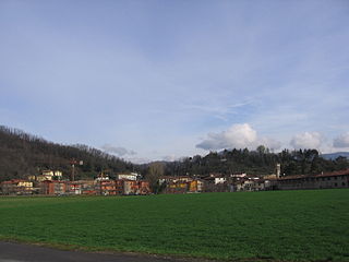
Palazzago is a comune (municipality) in the Province of Bergamo in the Italian region of Lombardy, located about 45 kilometres (28 mi) northeast of Milan and about 12 kilometres (7 mi) northwest of Bergamo. As of 31 December 2004, it had a population of 3,658 and an area of 14.0 square kilometres (5.4 sq mi). [1]

<i>Comune</i> third-level administrative divisions of the Italian Republic

The comune is a basic administrative division in Italy, roughly equivalent to a township or municipality.

Province of Bergamo Province of Italy

The Province of Bergamo is a province in the Lombardy region of Italy. It has a population of 1,112,187 (2017), an area of 2,754.91 square kilometers (1,063.68 sq mi), and contains 243 comuni. Its capital is the city of Bergamo.

Italy republic in Southern Europe

Italy, officially the Italian Republic, is a European country consisting of a peninsula delimited by the Italian Alps and surrounded by several islands. Located in the middle of the Mediterranean sea and traversed along its length by the Apennines, Italy has a largely temperate seasonal climate. The country covers an area of 301,340 km2 (116,350 sq mi) and shares open land borders with France, Slovenia, Austria, Switzerland and the enclaved microstates of Vatican City and San Marino. Italy has a territorial exclave in Switzerland (Campione) and a maritime exclave in the Tunisian sea (Lampedusa). With around 60 million inhabitants, Italy is the fourth-most populous member state of the European Union.

Palazzago borders the following municipalities: Almenno San Bartolomeo, Ambivere, Barzana, Caprino Bergamasco, Mapello, Pontida, Roncola.

Almenno San Bartolomeo Comune in Lombardy, Italy

Almenno San Bartolomeo is a comune (municipality) in the Province of Bergamo in the Italian region Lombardy, located about 45 kilometres (28 mi) northeast of Milan and about 9 kilometres (6 mi) northwest of Bergamo.

Ambivere Comune in Lombardy, Italy

Ambivere is a comune (municipality) in the Province of Bergamo in the Italian region of Lombardy, located about 40 kilometres (25 mi) northeast of Milan and about 9 kilometres (6 mi) west of Bergamo. As of 31 December 2004, it had a population of 2,265 and an area of 3.2 square kilometres (1.2 sq mi).

Barzana Comune in Lombardy, Italy

Barzana is a comune (municipality) in the Province of Bergamo in the Italian region of Lombardy, located about 45 kilometres (28 mi) northeast of Milan and about 9 kilometres (6 mi) northwest of Bergamo. As of 31 December 2004, it had a population of 1,645 and an area of 2.1 square kilometres (0.81 sq mi).

Demographic evolution

Palazzago

Related Research Articles

Antegnate Comune in Lombardy, Italy

Antegnate is a comune (municipality) in the Province of Bergamo in the Italian region of Lombardy, located about 50 kilometres (31 mi) east of Milan and about 25 kilometres (16 mi) southeast of Bergamo.

Caprino Bergamasco Comune in Lombardy, Italy

Caprino Bergamasco is a comune (municipality) in the Province of Bergamo in the Italian region of Lombardy, located about 40 kilometres (25 mi) northeast of Milan and about 15 kilometres (9 mi) northwest of Bergamo. As of 31 December 2004, it had a population of 2,908 and an area of 8.6 square kilometres (3.3 sq mi).

Fontanella, Lombardy Comune in Lombardy, Italy

Fontanella is a comune (municipality) in the Province of Bergamo in the Italian region of Lombardy, located about 50 kilometres (31 mi) east of Milan and about 30 kilometres (19 mi) southeast of Bergamo. As of 31 December 2004, it had a population of 3,773 and an area of 17.9 square kilometres (6.9 sq mi).

Fuipiano Valle Imagna Comune in Lombardy, Italy

Fuipiano Valle Imagna is a comune (municipality) in the Province of Bergamo in the Italian region of Lombardy, located about 50 kilometres (31 mi) northeast of Milan and about 20 kilometres (12 mi) northwest of Bergamo. As of 31 December 2004, it had a population of 238 and an area of 4.2 square kilometres (1.6 sq mi).

Gandellino Comune in Lombardy, Italy

Gandellino is a comune (municipality) in the Province of Bergamo in the Italian region of Lombardy, located about 90 kilometres (56 mi) northeast of Milan and about 40 kilometres (25 mi) northeast of Bergamo.

Gorle Comune in Lombardy, Italy

Gorle is a comune (municipality) in the Province of Bergamo in the Italian region of Lombardy, located about 50 kilometres (31 mi) northeast of Milan and about 4 kilometres (2 mi) east of Bergamo. As of 31 December 2004, it had a population of 5,506 and an area of 2.4 square kilometres (0.93 sq mi).

Grassobbio Comune in Lombardy, Italy

Grassobbio is a comune (municipality) in the Province of Bergamo in the Italian region of Lombardy, located about 50 kilometres (31 mi) northeast of Milan and about 7 kilometres (4 mi) southeast of Bergamo.

Grone, Lombardy Comune in Lombardy, Italy

Grone is a comune (municipality) in the Province of Bergamo in the Italian region of Lombardy, located about 70 kilometres (43 mi) northeast of Milan and about 20 kilometres (12 mi) east of Bergamo. As of 31 December 2004, it had a population of 817 and an area of 7.8 square kilometres (3.0 sq mi).

Madone Comune in Lombardy, Italy

Madone is a comune (municipality) in the Province of Bergamo in the Italian region of Lombardy, located about 35 kilometres (22 mi) northeast of Milan and about 11 kilometres (7 mi) southwest of Bergamo. As of 31 December 2004, it had a population of 3,501 and an area of 3.0 square kilometres (1.2 sq mi).

Mapello Comune in Lombardy, Italy

Mapello is a comune (municipality) in the Province of Bergamo in the Italian region of Lombardy, located about 40 kilometres (25 mi) northeast of Milan and about 9 kilometres (6 mi) west of Bergamo. As of 31 December 2004, it had a population of 5,806 and an area of 8.5 square kilometres (3.3 sq mi).

Montello, Lombardy Comune in Lombardy, Italy

Montello is a comune (municipality) in the Province of Bergamo in the Italian region of Lombardy, located about 50 kilometres (31 mi) northeast of Milan and about 11 kilometres (7 mi) southeast of Bergamo. As of 31 December 2004, it had a population of 2,668 and an area of 1.7 square kilometres (0.66 sq mi).

Paladina Comune in Lombardy, Italy

Paladina is a comune (municipality) in the Province of Bergamo in the Italian region of Lombardy, located about 45 kilometres (28 mi) northeast of Milan and about 5 kilometres (3 mi) northwest of Bergamo.

Pognano Comune in Lombardy, Italy

Pognano is a comune (municipality) in the Province of Bergamo in the Italian region of Lombardy, located about 40 kilometres (25 mi) northeast of Milan and about 13 kilometres (8 mi) south of Bergamo. As of 31 December 2004, it had a population of 1,374 and an area of 3.2 square kilometres (1.2 sq mi).

Pontida Comune in Lombardy, Italy

Pontida is a comune (municipality) in the Province of Bergamo in the Italian region of Lombardy, located about 40 kilometres (25 mi) northeast of Milan and about 13 kilometres (8 mi) northwest of Bergamo. As of 31 December 2004, it had a population of 3,112 and an area of 10.1 square kilometres (3.9 sq mi).

Roncola Comune in Lombardy, Italy

Roncola is a comune (municipality) in the Province of Bergamo in the Italian region of Lombardy, located about 45 kilometres (28 mi) northeast of Milan and about 12 kilometres (7 mi) northwest of Bergamo.

Telgate Comune in Lombardy, Italy

Telgate is a comune (municipality) in the Province of Bergamo in the Italian region of Lombardy, located about 60 kilometres (37 mi) northeast of Milan and about 15 kilometres (9 mi) southeast of Bergamo. As of 31 December 2004, it had a population of 4,598 and an area of 8.1 square kilometres (3.1 sq mi).

Valgoglio Comune in Lombardy, Italy

Valgoglio is a comune (municipality) in the Province of Bergamo in the Italian region of Lombardy, located about 80 kilometres (50 mi) northeast of Milan and about 35 kilometres (22 mi) northeast of Bergamo.

References

  1. All demographics and other statistics: Italian statistical institute Istat.