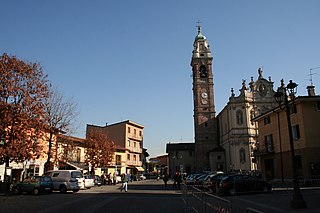
Brusaporto is a comune (municipality) in the Province of Bergamo in the Italian region of Lombardy, located about 50 kilometres (31 mi) northeast of Milan and about 9 kilometres (6 mi) southeast of Bergamo. As of 31 December 2004, it had a population of 4,524 and an area of 5.0 square kilometres (1.9 sq mi).
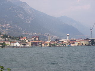
Castro is a comune (municipality) in the Province of Bergamo in the Italian region of Lombardy, located about 80 kilometres (50 mi) northeast of Milan and about 35 kilometres (22 mi) northeast of Bergamo on the western side of the lake Iseo. As of 31 December 2004, it had a population of 1,449 and an area of 3.5 square kilometres (1.4 sq mi).

Credaro is a comune (municipality) in the Province of Bergamo in the Italian region of Lombardy, located about 60 kilometres (37 mi) northeast of Milan and about 20 kilometres (12 mi) east of Bergamo. As of 31 December 2004, it had a population of 2,608 and an area of 3.4 square kilometres (1.3 sq mi).
Curno is a comune (municipality) in the Province of Bergamo in the Italian region of Lombardy, located about 40 kilometres (25 mi) northeast of Milan and about 6 kilometres (4 mi) southwest of Bergamo. As of 31 December 2006, it had a population of 7,590 and an area of 4.62 square kilometres (1.78 sq mi).

Fino del Monte is a comune (municipality) in the Province of Bergamo in the Italian region of Lombardy, located about 80 kilometres (50 mi) northeast of Milan and about 35 kilometres (22 mi) northeast of Bergamo. As of 31 December 2004, it had a population of 1,156 and an area of 4.4 square kilometres (1.7 sq mi).

Gorle is a comune (municipality) in the Province of Bergamo in the Italian region of Lombardy, located about 50 kilometres (31 mi) northeast of Milan and about 4 kilometres (2 mi) east of Bergamo. As of 31 December 2004, it had a population of 5,506 and an area of 2.4 square kilometres (0.93 sq mi).
Lurano is a comune (municipality) in the Province of Bergamo in the Italian region of Lombardy, located about 40 kilometres (25 mi) northeast of Milan and about 15 kilometres (9 mi) south of Bergamo. As of 31 December 2004, it had a population of 2,201 and an area of 4.0 square kilometres (1.5 sq mi).
Luzzana is a comune (municipality) in the Province of Bergamo in the Italian region of Lombardy, located about 60 kilometres (37 mi) northeast of Milan and about 15 kilometres (9 mi) east of Bergamo. As of 31 December 2004, it had a population of 776 and an area of 3.4 square kilometres (1.3 sq mi).

Mozzo is a comune (municipality) in the Province of Bergamo in the Italian region of Lombardy, located about 45 kilometres (28 mi) northeast of Milan and about 5 kilometres (3 mi) west of Bergamo. As of 31 December 2004, it had a population of 7,202 and an area of 3.6 square kilometres (1.4 sq mi).
Pedrengo is a comune (municipality) in the Province of Bergamo in the Italian region of Lombardy, located about 50 kilometres (31 mi) northeast of Milan and about 5 kilometres (3 mi) east of Bergamo. As of 31 December 2004, it had a population of 5,321 and an area of 3.6 square kilometres (1.4 sq mi).

Peia is a comune (municipality) in the Province of Bergamo in the Italian region of Lombardy, located about 70 kilometres (43 mi) northeast of Milan and about 20 kilometres (12 mi) northeast of Bergamo. As of 31 December 2004, it had a population of 1,817 and an area of 4.4 square kilometres (1.7 sq mi).

Pontirolo Nuovo is a comune (municipality) in the Province of Bergamo in the Italian region of Lombardy, located about 40 kilometres (25 mi) northeast of Milan and about 18 kilometres (11 mi) northeast of Bergamo. As of 31 December 2004, it had a population of 4,649 and an area of 10.8 square kilometres (4.2 sq mi).

Predore is a comune (municipality) in the Province of Bergamo in the Italian region of Lombardy, located about 70 kilometres (43 mi) northeast of Milan and about 25 kilometres (16 mi) east of Bergamo. As of 31 December 2004, it had a population of 1,837 and an area of 11.6 square kilometres (4.5 sq mi).

Valbrembo is a comune (municipality) in the Province of Bergamo in the Italian region of Lombardy, located about 45 kilometres (28 mi) northeast of Milan and about 4 kilometres (2 mi) northwest of Bergamo. As of 31 December 2004, it had a population of 3,584 and an area of 3.7 square kilometres (1.4 sq mi).

Verdellino is a comune (municipality) in the Province of Bergamo in the Italian region of Lombardy, located about 40 kilometres (25 mi) northeast of Milan and about 12 kilometres (7 mi) southwest of Bergamo. The town is easily reachable by train, the station of Verdello-Dalmine is in fact located on Verdellino's soil and the stop is one of several on the railroad line that connects the two cities of Bergamo and Milan. As of 31 December 2004, it had a population of 7,186 and an area of 3.8 square kilometres (1.5 sq mi).

Viadanica is a comune (municipality) in the Province of Bergamo in the Italian region of Lombardy, located about 70 kilometres (43 mi) northeast of Milan and about 25 kilometres (16 mi) east of Bergamo. As of 31 December 2004, it had a population of 1,093 and an area of 5.4 square kilometres (2.1 sq mi).

Villa di Serio is a comune (municipality) in the Province of Bergamo in the Italian region of Lombardy, located about 50 kilometres (31 mi) northeast of Milan and about 6 kilometres (4 mi) northeast of Bergamo. As of 31 December 2004, it had a population of 6,118 and an area of 4.6 square kilometres (1.8 sq mi).