Verdellino

Last updated
Verdellino
Comune
Comune di Verdellino
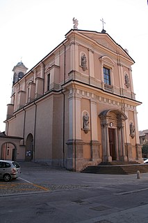
Madonnadell'olmo3.JPG
Church
Italy provincial location map 2015.svg
Red pog.svg
Verdellino
Location of Verdellino in Italy
Coordinates: 45°36′N9°37′E / 45.600°N 9.617°E / 45.600; 9.617 Coordinates: 45°36′N9°37′E / 45.600°N 9.617°E / 45.600; 9.617
Country Italy
Region Lombardy
Province Province of Bergamo (BG)
Area
  Total 3.8 km2 (1.5 sq mi)
Elevation 172 m (564 ft)
Population (Dec. 2004)
  Total 7,186
  Density 1,900/km2 (4,900/sq mi)
Demonym(s) Verdellinesi
Time zone CET (UTC+1)
  Summer (DST) CEST (UTC+2)
Postal code24049
Dialing code 035

Verdellino (Bergamasque: Erdelì) is a comune (municipality) in the Province of Bergamo in the Italian region of Lombardy, located about 40 kilometres (25 mi) northeast of Milan and about 12 kilometres (7 mi) southwest of Bergamo. The town is easily reachable by train, the station of Verdello-Dalmine is in fact located on Verdellino's soil and the stop is one of several on the railroad line that connects the two cities of Bergamo and Milan. As of 31 December 2004, it had a population of 7,186 and an area of 3.8 square kilometres (1.5 sq mi). [1]

<i>Comune</i> third-level administrative divisions of the Italian Republic

The comune is a basic administrative division in Italy, roughly equivalent to a township or municipality.

Province of Bergamo Province of Italy

The Province of Bergamo is a province in the Lombardy region of Italy. It has a population of 1,112,187 (2017), an area of 2,754.91 square kilometers (1,063.68 sq mi), and contains 243 comuni. Its capital is the city of Bergamo.

Italy republic in Southern Europe

Italy, officially the Italian Republic, is a country in Southern Europe. Located in the middle of the Mediterranean Sea, Italy shares open land borders with France, Switzerland, Austria, Slovenia and the enclaved microstates San Marino and Vatican City. Italy covers an area of 301,340 km2 (116,350 sq mi) and has a largely temperate seasonal and Mediterranean climate. With around 61 million inhabitants, it is the fourth-most populous EU member state and the most populous country in Southern Europe.

Contents

Verdellino borders the following municipalities: Boltiere, Ciserano, Levate, Osio Sotto, Verdello.

Boltiere Comune in Lombardy, Italy

Boltiere is a comune (municipality) in the Province of Bergamo in the Italian region of Lombardy, located about 35 kilometres (22 mi) northeast of Milan and about 13 kilometres (8 mi) southwest of Bergamo. As of 31 December 2004, it had a population of 4,695 and an area of 4.1 square kilometres (1.6 sq mi).

Ciserano Comune in Lombardy, Italy

Ciserano is a comune (municipality) in the Province of Bergamo in the Italian region of Lombardy, located about 35 kilometres (22 mi) northeast of Milan and about 14 kilometres (9 mi) southwest of Bergamo. As of 31 December 2004, it had a population of 5,270 and an area of 5.2 square kilometres (2.0 sq mi).

Levate Comune in Lombardy, Italy

Levate is a comune (municipality) in the Province of Bergamo in the Italian region of Lombardy, located about 40 kilometres (25 mi) northeast of Milan and about 8 kilometres (5 mi) southwest of Bergamo.

Demographic evolution

Verdellino

Transportation

Related Research Articles

Verdello Comune in Lombardy, Italy

Verdello is a comune in the province of Bergamo, Lombardy, Italy. It has a population of 6,494.

Arcene Comune in Lombardy, Italy

Arcene is a comune (municipality) in the Province of Bergamo in the Italian region of Lombardy, located about 35 kilometres (22 mi) northeast of Milan and about 14 kilometres (9 mi) southwest of Bergamo. As of 31 December 2004, it had a population of 4,529 and an area of 4.2 square kilometres (1.6 sq mi).

Aviatico Comune in Lombardy, Italy

Aviatico is a comune (municipality) in the Province of Bergamo in the Italian region of Lombardy, located about 60 kilometres (37 mi) northeast of Milan and about 12 kilometres (7 mi) northeast of Bergamo. As of 31 December 2007, it had a population of 515 and an area of 8.4 square kilometres (3.2 sq mi).

Castel Rozzone Comune in Lombardy, Italy

Castel Rozzone is a comune (municipality) in the Province of Bergamo in the Italian region of Lombardy, located about 40 kilometres (25 mi) east of Milan and about 15 kilometres (9 mi) south of Bergamo. As of 31 December 2004, it had a population of 2,705 and an area of 1.7 square kilometres (0.66 sq mi).

Colere Comune in Lombardy, Italy

Colere is a comune (municipality) in the Province of Bergamo in the Italian region of Lombardy, located about 90 kilometres (56 mi) northeast of Milan and about 45 kilometres (28 mi) northeast of Bergamo. As of 31 December 2004, it had a population of 1,147 and an area of 18.8 square kilometres (7.3 sq mi).

Colzate Comune in Lombardy, Italy

Colzate is a comune (municipality) in the Province of Bergamo in the Italian region of Lombardy, located about 70 kilometres (43 mi) northeast of Milan and about 20 kilometres (12 mi) northeast of Bergamo. As of 31 December 2004, it had a population of 1,638 and an area of 6.7 square kilometres (2.6 sq mi).

Comun Nuovo Comune in Lombardy, Italy

Comun Nuovo is a comune (municipality) in the Province of Bergamo in the Italian region of Lombardy, located about 40 kilometres (25 mi) northeast of Milan and about 9 kilometres (6 mi) south of Bergamo.

Dalmine Comune in Lombardy, Italy

Dalmine is a comune (municipality) in the Province of Bergamo in the Italian region of Lombardy, located about 40 kilometres (25 mi) northeast of Milan and about 8 kilometres (5 mi) southwest of Bergamo. As of 31 December 2004, it had a population of 22,326 and an area of 11.6 square kilometres (4.5 sq mi).

Filago Comune in Lombardy, Italy

Filago is a comune (municipality) in the Province of Bergamo in the Italian region of Lombardy, located about 35 kilometres (22 mi) northeast of Milan and about 12 kilometres (7 mi) southwest of Bergamo.

Lallio Comune in Lombardy, Italy

Lallio is a comune (municipality) in the Province of Bergamo in the Italian region of Lombardy, located about 45 kilometres (28 mi) northeast of Milan and about 5 kilometres (3.1 mi) southwest of Bergamo. As of 31 December 2004, it had a population of 4,050 and an area of 2.1 square kilometres (0.81 sq mi).

Mornico al Serio Comune in Lombardy, Italy

Mornico al Serio is a comune (municipality) in the Province of Bergamo in the Italian region of Lombardy, located about 50 kilometres (31 mi) northeast of Milan and about 14 kilometres (9 mi) southeast of Bergamo. As of 31 December 2004, it had a population of 2,632 and an area of 7.0 square kilometres (2.7 sq mi).

Osio Sotto Comune in Lombardy, Italy

Osio Sotto is a comune (municipality) in the Province of Bergamo in the Italian region of Lombardy, located about 40 kilometres (25 mi) northeast of Milan and about 11 kilometres (7 mi) southwest of Bergamo. As of 31 December 2004, it had a population of 11,097 and an area of 7.5 square kilometres (2.9 sq mi).

Peia Comune in Lombardy, Italy

Peia is a comune (municipality) in the Province of Bergamo in the Italian region of Lombardy, located about 70 kilometres (43 mi) northeast of Milan and about 20 kilometres (12 mi) northeast of Bergamo. As of 31 December 2004, it had a population of 1,817 and an area of 4.4 square kilometres (1.7 sq mi).

Pognano Comune in Lombardy, Italy

Pognano is a comune (municipality) in the Province of Bergamo in the Italian region of Lombardy, located about 40 kilometres (25 mi) northeast of Milan and about 13 kilometres (8 mi) south of Bergamo. As of 31 December 2004, it had a population of 1,374 and an area of 3.2 square kilometres (1.2 sq mi).

Premolo Comune in Lombardy, Italy

Premolo is a comune (municipality) in the Province of Bergamo in the Italian region of Lombardy, located about 70 kilometres (43 mi) northeast of Milan and about 25 kilometres (16 mi) northeast of Bergamo. As of 31 December 2004, it had a population of 1,094 and an area of 18.3 square kilometres (7.1 sq mi).

Spirano Comune in Lombardy, Italy

Spirano is a comune (municipality) in the Province of Bergamo in the Italian region of Lombardy, located about 40 kilometres (25 mi) northeast of Milan and about 13 kilometres (8 mi) south of Bergamo.

Vedeseta Comune in Lombardy, Italy

Vedeseta is a comune (municipality) in the Province of Bergamo in the Italian region of Lombardy, located about 50 kilometres (31 mi) northeast of Milan and about 25 kilometres (16 mi) northwest of Bergamo. As of 31 December 2004, it had a population of 244 and an area of 19.8 square kilometres (7.6 sq mi).

References

  1. All demographics and other statistics: Italian statistical institute Istat.