Gorno

Last updated
Gorno
Góren
Comune
Comune di Gorno
Gorno vista 02.jpg
Gorno
Italy provincial location map 2015.svg
Red pog.svg
Gorno
Location of Gorno in Italy
Coordinates: 45°52′N9°50′E / 45.867°N 9.833°E / 45.867; 9.833 Coordinates: 45°52′N9°50′E / 45.867°N 9.833°E / 45.867; 9.833
Country Italy
Region Lombardy
Province Province of Bergamo (BG)
Frazioni Riso, Chignolo, Erdeno, Campello, Sant'Antonio
Area
  Total 9.9 km2 (3.8 sq mi)
Elevation 710 m (2,330 ft)
Population (Dec. 2004)
  Total 1,760
  Density 180/km2 (460/sq mi)
Demonym(s) Gornesi
Time zone CET (UTC+1)
  Summer (DST) CEST (UTC+2)
Postal code24020
Dialing code 035

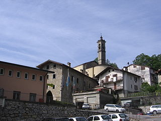
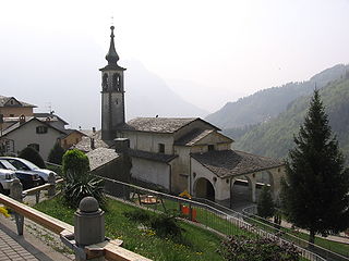
Gorno (Bergamasque: Góren) is a comune (municipality) in the Province of Bergamo in the Italian region of Lombardy, located about 70 km (43 mi) northeast of Milan and about 25 km (16 mi) northeast of Bergamo. As of 31 December 2004, it had a population of 1,760 and an area of 9.9 km2 (3.8 sq mi). [1]

<i>Comune</i> third-level administrative divisions of the Italian Republic

The comune is a basic administrative division in Italy, roughly equivalent to a township or municipality.

Province of Bergamo Province of Italy

The Province of Bergamo is a province in the Lombardy region of Italy. It has a population of 1,112,187 (2017), an area of 2,754.91 square kilometers (1,063.68 sq mi), and contains 243 comuni. Its capital is the city of Bergamo.

Italy republic in Southern Europe

Italy, officially the Italian Republic, is a country in Southern Europe. Located in the middle of the Mediterranean Sea, Italy shares open land borders with France, Switzerland, Austria, Slovenia and the enclaved microstates San Marino and Vatican City. Italy covers an area of 301,340 km2 (116,350 sq mi) and has a largely temperate seasonal and Mediterranean climate. With around 61 million inhabitants, it is the fourth-most populous EU member state and the most populous country in Southern Europe.

The municipality of Gorno contains the frazioni (subdivisions, mainly villages and hamlets) Riso, Chignolo, Erdeno, Campello, and Sant'Antonio.

"Frazione" is the Italian name given in administrative law to a type of territorial subdivision of a comune; for other administrative divisions, see municipio, circoscrizione, quartiere. It is cognate to the English word fraction, but in practice is roughly equivalent to "parishes" or "wards" in other countries.

Gorno borders the following municipalities: Casnigo, Colzate, Oneta, Ponte Nossa, Premolo.

Casnigo Comune in Lombardy, Italy

Casnigo is a comune (municipality) in the Province of Bergamo in the Italian region of Lombardy, located about 70 kilometres (43 mi) northeast of Milan and about 20 kilometres (12 mi) northeast of Bergamo.

Colzate Comune in Lombardy, Italy

Colzate is a comune (municipality) in the Province of Bergamo in the Italian region of Lombardy, located about 70 kilometres (43 mi) northeast of Milan and about 20 kilometres (12 mi) northeast of Bergamo. As of 31 December 2004, it had a population of 1,638 and an area of 6.7 square kilometres (2.6 sq mi).

Oneta, Lombardy Comune in Lombardy, Italy

Oneta is a comune (municipality) in the Province of Bergamo in the Italian region of Lombardy, located about 70 kilometres (43 mi) northeast of Milan and about 20 kilometres (12 mi) northeast of Bergamo. As of 31 December 2004, it had a population of 731 and an area of 18.3 square kilometres (7.1 sq mi).

Demographic evolution

Gorno

Related Research Articles

Aviatico Comune in Lombardy, Italy

Aviatico is a comune (municipality) in the Province of Bergamo in the Italian region of Lombardy, located about 60 kilometres (37 mi) northeast of Milan and about 12 kilometres (7 mi) northeast of Bergamo. As of 31 December 2007, it had a population of 515 and an area of 8.4 square kilometres (3.2 sq mi).

Bracca Comune in Lombardy, Italy

Bracca is a comune (municipality) in the Province of Bergamo in the Italian region of Lombardy, located about 60 kilometres (37 mi) northeast of Milan and about 14 kilometres (9 mi) northeast of Bergamo. As of 31 December 2004, it had a population of 827 and an area of 5.5 square kilometres (2.1 sq mi).

Castro, Lombardy Comune in Lombardy, Italy

Castro is a comune (municipality) in the Province of Bergamo in the Italian region of Lombardy, located about 80 kilometres (50 mi) northeast of Milan and about 35 kilometres (22 mi) northeast of Bergamo on the western side of the lake Iseo. As of 31 December 2004, it had a population of 1,449 and an area of 3.5 square kilometres (1.4 sq mi).

Cene Comune in Lombardy, Italy

Cene is a comune (municipality) in the Province of Bergamo in the Italian region of Lombardy, located about 60 kilometres (37 mi) northeast of Milan and about 15 kilometres (9 mi) northeast of Bergamo.

Colere Comune in Lombardy, Italy

Colere is a comune (municipality) in the Province of Bergamo in the Italian region of Lombardy, located about 90 kilometres (56 mi) northeast of Milan and about 45 kilometres (28 mi) northeast of Bergamo. As of 31 December 2004, it had a population of 1,147 and an area of 18.8 square kilometres (7.3 sq mi).

Dalmine Comune in Lombardy, Italy

Dalmine is a comune (municipality) in the Province of Bergamo in the Italian region of Lombardy, located about 40 kilometres (25 mi) northeast of Milan and about 8 kilometres (5 mi) southwest of Bergamo. As of 31 December 2004, it had a population of 22,326 and an area of 11.6 square kilometres (4.5 sq mi).

Entratico Comune in Lombardy, Italy

Entratico is a comune (municipality) in the Province of Bergamo in the Italian region of Lombardy, located about 60 kilometres (37 mi) northeast of Milan and about 15 kilometres (9.3 mi) east of Bergamo. As of 31 December 2004, it had a population of 1,620 and an area of 4.1 km².

Fiorano al Serio Comune in Lombardy, Italy

Fiorano al Serio is a comune (municipality) in the Province of Bergamo in the Italian region of Lombardy, located about 60 kilometres (37 mi) northeast of Milan and about 15 kilometres (9 mi) northeast of Bergamo.

Foppolo Comune in Lombardy, Italy

Foppolo is a comune (municipality) in the Province of Bergamo in the Italian region of Lombardy, located about 120 kilometres (75 mi) northeast of Milan and about 60 kilometres (37 mi) north of Bergamo. As of 31 December 2004, it had a population of 206 and an area of 16.2 square kilometres (6.3 sq mi).

Gandellino Comune in Lombardy, Italy

Gandellino is a comune (municipality) in the Province of Bergamo in the Italian region of Lombardy, located about 90 kilometres (56 mi) northeast of Milan and about 40 kilometres (25 mi) northeast of Bergamo.

Peia Comune in Lombardy, Italy

Peia is a comune (municipality) in the Province of Bergamo in the Italian region of Lombardy, located about 70 kilometres (43 mi) northeast of Milan and about 20 kilometres (12 mi) northeast of Bergamo. As of 31 December 2004, it had a population of 1,817 and an area of 4.4 square kilometres (1.7 sq mi).

Piario Comune in Lombardy, Italy

Piario is a comune (municipality) in the Province of Bergamo in the Italian region of Lombardy, located about 80 kilometres (50 mi) northeast of Milan and about 30 kilometres (19 mi) northeast of Bergamo. As of 31 December 2004, it had a population of 990 and an area of 1.5 square kilometres (0.58 sq mi).

Ponte Nossa Comune in Lombardy, Italy

Ponte Nossa is a comune (municipality) in the Province of Bergamo in the Italian region of Lombardy, located about 70 kilometres (43 mi) northeast of Milan and about 25 kilometres (16 mi) northeast of Bergamo. As of 31 December 2004, it had a population of 2,048 and an area of 5.6 square kilometres (2.2 sq mi).

Premolo Comune in Lombardy, Italy

Premolo is a comune (municipality) in the Province of Bergamo in the Italian region of Lombardy, located about 70 kilometres (43 mi) northeast of Milan and about 25 kilometres (16 mi) northeast of Bergamo. As of 31 December 2004, it had a population of 1,094 and an area of 18.3 square kilometres (7.1 sq mi).

Songavazzo Comune in Lombardy, Italy

Songavazzo is a comune (municipality) in the Province of Bergamo in the Italian region of Lombardy, located about 80 kilometres (50 mi) northeast of Milan and about 30 kilometres (19 mi) northeast of Bergamo. As of 31 December 2004, it had a population of 662 and an area of 12.7 square kilometres (4.9 sq mi).

Valgoglio Comune in Lombardy, Italy

Valgoglio is a comune (municipality) in the Province of Bergamo in the Italian region of Lombardy, located about 80 kilometres (50 mi) northeast of Milan and about 35 kilometres (22 mi) northeast of Bergamo.

Villa di Serio Comune in Lombardy, Italy

Villa di Serio is a comune (municipality) in the Province of Bergamo in the Italian region of Lombardy, located about 50 kilometres (31 mi) northeast of Milan and about 6 kilometres (4 mi) northeast of Bergamo. As of 31 December 2004, it had a population of 6,118 and an area of 4.6 square kilometres (1.8 sq mi).

References

  1. All demographics and other statistics: Italian statistical institute Istat.