Pontirolo Nuovo

Last updated
Pontirolo Nuovo
Comune
Comune di Pontirolo Nuovo
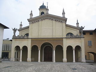
Pontirolo Nuovo1.JPG
Church
Italy provincial location map 2015.svg
Red pog.svg
Pontirolo Nuovo
Location of Pontirolo Nuovo in Italy
Coordinates: 45°34′N9°34′E / 45.567°N 9.567°E / 45.567; 9.567 Coordinates: 45°34′N9°34′E / 45.567°N 9.567°E / 45.567; 9.567
Country Italy
Region Lombardy
Province Province of Bergamo (BG)
Frazioni Fornasotto, PONCIPARELLO
Area
  Total 10.8 km2 (4.2 sq mi)
Elevation 155 m (509 ft)
Population (Dec. 2004)
  Total 4,649
  Density 430/km2 (1,100/sq mi)
Demonym(s) Pontirolesi
Time zone CET (UTC+1)
  Summer (DST) CEST (UTC+2)
Postal code24040
Dialing code 0363

Pontirolo Nuovo (Bergamasque: Puntiröl) is a comune (municipality) in the Province of Bergamo in the Italian region of Lombardy, located about 40 kilometres (25 mi) northeast of Milan and about 18 kilometres (11 mi) northeast of Bergamo. As of 31 December 2004, it had a population of 4,649 and an area of 10.8 square kilometres (4.2 sq mi). [1]

<i>Comune</i> third-level administrative divisions of the Italian Republic

The comune is a basic administrative division in Italy, roughly equivalent to a township or municipality.

Province of Bergamo Province of Italy

The Province of Bergamo is a province in the Lombardy region of Italy. It has a population of 1,112,187 (2017), an area of 2,754.91 square kilometers (1,063.68 sq mi), and contains 243 comuni. Its capital is the city of Bergamo.

Italy republic in Southern Europe

Italy, officially the Italian Republic, is a European country consisting of a peninsula delimited by the Italian Alps and surrounded by several islands. Located in the middle of the Mediterranean sea and traversed along its length by the Apennines, Italy has a largely temperate seasonal climate. The country covers an area of 301,340 km2 (116,350 sq mi) and shares open land borders with France, Slovenia, Austria, Switzerland and the enclaved microstates of Vatican City and San Marino. Italy has a territorial exclave in Switzerland (Campione) and a maritime exclave in the Tunisian sea (Lampedusa). With around 60 million inhabitants, Italy is the fourth-most populous member state of the European Union.

The municipality of Pontirolo Nuovo contains the frazione (subdivision) Fornasotto.

"Frazione" is the Italian name given in administrative law to a type of territorial subdivision of a comune; for other administrative divisions, see municipio, circoscrizione, quartiere. It is cognate to the English word fraction, but in practice is roughly equivalent to "parishes" or "wards" in other countries.

Pontirolo Nuovo borders the following municipalities: Arcene, Boltiere, Brembate, Canonica d'Adda, Ciserano, Fara Gera d'Adda, Treviglio.

Arcene Comune in Lombardy, Italy

Arcene is a comune (municipality) in the Province of Bergamo in the Italian region of Lombardy, located about 35 kilometres (22 mi) northeast of Milan and about 14 kilometres (9 mi) southwest of Bergamo. As of 31 December 2004, it had a population of 4,529 and an area of 4.2 square kilometres (1.6 sq mi).

Boltiere Comune in Lombardy, Italy

Boltiere is a comune (municipality) in the Province of Bergamo in the Italian region of Lombardy, located about 35 kilometres (22 mi) northeast of Milan and about 13 kilometres (8 mi) southwest of Bergamo. As of 31 December 2004, it had a population of 4,695 and an area of 4.1 square kilometres (1.6 sq mi).

Brembate Comune in Lombardy, Italy

Brembate is a comune (municipality) in the Province of Bergamo in the Italian region of Lombardy, located about 35 kilometres (22 mi) northeast of Milan and about 14 kilometres (9 mi) southwest of Bergamo. As of 31 December 2010, it had a population of 8,234 and an area of 5.5 square kilometres (2.1 sq mi).

Demographic evolution

Pontirolo Nuovo

Related Research Articles

Bottanuco Comune in Lombardy, Italy

Bottanuco is a comune (municipality) in the Province of Bergamo in the Italian region of Lombardy, located about 35 kilometres (22 mi) northeast of Milan and about 14 kilometres (9 mi) southwest of Bergamo. As of 31 December 2004, it had a population of 4,874 and an area of 5.7 square kilometres (2.2 sq mi).

Brignano Gera dAdda Comune in Lombardy, Italy

Brignano Gera d'Adda is a comune (municipality) in the Province of Bergamo in the Italian region of Lombardy, located about 35 kilometres (22 mi) east of Milan and about 20 kilometres (12 mi) south of Bergamo.

Calusco dAdda Comune in Lombardy, Italy

Calusco d'Adda is a comune (municipality) in the Province of Bergamo in the Italian region of Lombardy, located about 35 kilometres (22 mi) northeast of Milan and about 14 kilometres (9 mi) west of Bergamo.

Calvenzano Comune in Lombardy, Italy

Calvenzano is a comune (municipality) in the Province of Bergamo in the Italian region of Lombardy, located about 35 kilometres (22 mi) east of Milan and about 25 kilometres (16 mi) south of Bergamo. As of 31 December 2004, it had a population of 3,618 and an area of 6.5 square kilometres (2.5 sq mi).

Canonica dAdda Comune in Lombardy, Italy

Canonica d'Adda is a comune (municipality) in the Province of Bergamo in the Italian region of Lombardy, located about 30 kilometres (19 mi) northeast of Milan and about 15 kilometres (9 mi) southwest of Bergamo.

Caprino Bergamasco Comune in Lombardy, Italy

Caprino Bergamasco is a comune (municipality) in the Province of Bergamo in the Italian region of Lombardy, located about 40 kilometres (25 mi) northeast of Milan and about 15 kilometres (9 mi) northwest of Bergamo. As of 31 December 2004, it had a population of 2,908 and an area of 8.6 square kilometres (3.3 sq mi).

Carvico Comune in Lombardy, Italy

Carvico is a comune (municipality) in the Province of Bergamo in the Italian region of Lombardy, located about 35 kilometres northeast of Milan and about 14 km (9 mi) west of Bergamo. As of 31 December 2004, it had a population of 4,355 and an area of 4.4 square kilometres (1.7 sq mi).

Ciserano Comune in Lombardy, Italy

Ciserano is a comune (municipality) in the Province of Bergamo in the Italian region of Lombardy, located about 35 kilometres (22 mi) northeast of Milan and about 14 kilometres (9 mi) southwest of Bergamo. As of 31 December 2004, it had a population of 5,270 and an area of 5.2 square kilometres (2.0 sq mi).

Cologno al Serio Comune in Lombardy, Italy

Cologno al Serio is a comune (municipality) in the Province of Bergamo in the Italian region of Lombardy, located about 45 kilometres (28 mi) northeast of Milan and about 10 kilometres (6 mi) south of Bergamo.

Fara Gera dAdda Comune in Lombardy, Italy

Fara Gera d'Adda is a comune (municipality) in the Province of Bergamo in the Italian region of Lombardy, located about 30 kilometres (19 mi) northeast of Milan and about 20 kilometres (12 mi) southwest of Bergamo. As of 31 December 2004, it had a population of 7,396 and an area of 10.6 square kilometres (4.1 sq mi).

Lurano Comune in Lombardy, Italy

Lurano is a comune (municipality) in the Province of Bergamo in the Italian region of Lombardy, located about 40 kilometres (25 mi) northeast of Milan and about 15 kilometres (9 mi) south of Bergamo. As of 31 December 2004, it had a population of 2,201 and an area of 4.0 square kilometres (1.5 sq mi).

Misano di Gera dAdda Comune in Lombardy, Italy

Misano di Gera d'Adda is a comune (municipality) in the Province of Bergamo in the Italian region of Lombardy, located about 35 kilometres (22 mi) east of Milan and about 25 kilometres (16 mi) south of Bergamo. As of 31 December 2004, it had a population of 2,877 and an area of 6.1 square kilometres (2.4 sq mi).

Spirano Comune in Lombardy, Italy

Spirano is a comune (municipality) in the Province of Bergamo in the Italian region of Lombardy, located about 40 kilometres (25 mi) northeast of Milan and about 13 kilometres (8 mi) south of Bergamo.

Suisio Comune in Lombardy, Italy

Suisio is a comune in the Italian region of Lombardy, located about 35 kilometres (22 mi) northeast of Milan and about 14 kilometres (9 mi) southwest of Bergamo. As of 31 December 2004, it had a population of 3,614 and an area of 4.6 square kilometres (1.8 sq mi).

Villa dAdda Comune in Lombardy, Italy

Villa d'Adda is a comune (municipality) in the Province of Bergamo in the Italian region of Lombardy, located about 35 kilometres (22 mi) northeast of Milan and about 15 kilometres (9 mi) west of Bergamo. As of November 2012, it had a population of 4,754 and an area of 5.98 square kilometres (2.31 sq mi).

Medolago Comune in Lombardy, Italy

Medolago is a comune (municipality) in the Province of Bergamo in the Italian region of Lombardy, located about 35 kilometres (22 mi) northeast of Milan and about 14 kilometres (9 mi) southwest of Bergamo. As of 31 December 2004, it had a population of 2,231 and an area of 3.8 square kilometres (1.5 sq mi).

Solza Comune in Lombardy, Italy

Solza is a comune (municipality) in the Province of Bergamo in the Italian region of Lombardy, located about 35 kilometres (22 mi) northeast of Milan and about 14 kilometres (9 mi) west of Bergamo.

References

  1. All demographics and other statistics: Italian statistical institute Istat.