
Antegnate is a comune (municipality) in the Province of Bergamo in the Italian region of Lombardy, located about 50 kilometres (31 mi) east of Milan and about 25 kilometres (16 mi) southeast of Bergamo.

Aviatico is a comune (municipality) in the Province of Bergamo in the Italian region of Lombardy, located about 60 kilometres (37 mi) northeast of Milan and about 12 kilometres (7 mi) northeast of Bergamo. As of 31 December 2007, it had a population of 515 and an area of 8.4 square kilometres (3.2 sq mi).

Boltiere is a comune (municipality) in the Province of Bergamo in the Italian region of Lombardy, located about 35 kilometres (22 mi) northeast of Milan and about 13 kilometres (8 mi) southwest of Bergamo. As of 31 December 2004, it had a population of 4,695 and an area of 4.1 square kilometres (1.6 sq mi).

Brumano is a comune (municipality) in the Province of Bergamo in the Italian region of Lombardy, located about 50 kilometres (31 mi) northeast of Milan and about 20 kilometres (12 mi) northwest of Bergamo. As of 31 December 2004, it had a population of 96 and an area of 8.1 square kilometres (3.1 sq mi).
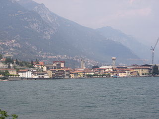
Castro is a comune (municipality) in the Province of Bergamo in the Italian region of Lombardy, located about 80 kilometres (50 mi) northeast of Milan and about 35 kilometres (22 mi) northeast of Bergamo on the western side of the lake Iseo. As of 31 December 2004, it had a population of 1,449 and an area of 3.5 square kilometres (1.4 sq mi).

Colzate is a comune (municipality) in the Province of Bergamo in the Italian region of Lombardy, located about 70 kilometres (43 mi) northeast of Milan and about 20 kilometres (12 mi) northeast of Bergamo. As of 31 December 2004, it had a population of 1,638 and an area of 6.7 square kilometres (2.6 sq mi).

Gandellino is a comune (municipality) in the Province of Bergamo in the Italian region of Lombardy, located about 90 kilometres (56 mi) northeast of Milan and about 40 kilometres (25 mi) northeast of Bergamo.

Ghisalba is a comune (municipality) in the Province of Bergamo in the Italian region of Lombardy, located about 50 kilometres (31 mi) northeast of Milan and about 13 kilometres (8 mi) southeast of Bergamo. As of 31 December 2010, it had a population of 5,967 and an area of 10.2 square kilometres (3.9 sq mi).

Gorle is a comune (municipality) in the Province of Bergamo in the Italian region of Lombardy, located about 50 kilometres (31 mi) northeast of Milan and about 4 kilometres (2 mi) east of Bergamo. As of 31 December 2004, it had a population of 5,506 and an area of 2.4 square kilometres (0.93 sq mi).

Misano di Gera d'Adda is a comune (municipality) in the Province of Bergamo in the Italian region of Lombardy, located about 35 kilometres (22 mi) east of Milan and about 25 kilometres (16 mi) south of Bergamo. As of 31 December 2004, it had a population of 2,877 and an area of 6.1 square kilometres (2.4 sq mi).

Mornico al Serio is a comune (municipality) in the Province of Bergamo in the Italian region of Lombardy, located about 50 kilometres (31 mi) northeast of Milan and about 14 kilometres (9 mi) southeast of Bergamo. As of 31 December 2004, it had a population of 2,632 and an area of 7.0 square kilometres (2.7 sq mi).

Paladina is a comune (municipality) in the Province of Bergamo in the Italian region of Lombardy, located about 45 kilometres (28 mi) northeast of Milan and about 5 kilometres (3 mi) northwest of Bergamo.

Peia is a comune (municipality) in the Province of Bergamo in the Italian region of Lombardy, located about 70 kilometres (43 mi) northeast of Milan and about 20 kilometres (12 mi) northeast of Bergamo. As of 31 December 2004, it had a population of 1,817 and an area of 4.4 square kilometres (1.7 sq mi).

Piario is a comune (municipality) in the Province of Bergamo in the Italian region of Lombardy, located about 80 kilometres (50 mi) northeast of Milan and about 30 kilometres (19 mi) northeast of Bergamo. As of 31 December 2004, it had a population of 990 and an area of 1.5 square kilometres (0.58 sq mi).

Premolo is a comune (municipality) in the Province of Bergamo in the Italian region of Lombardy, located about 70 kilometres (43 mi) northeast of Milan and about 25 kilometres (16 mi) northeast of Bergamo. As of 31 December 2004, it had a population of 1,094 and an area of 18.3 square kilometres (7.1 sq mi).

Santa Brigida is a comune (municipality) in the Province of Bergamo in the Italian region of Lombardy, located about 70 kilometres (43 mi) northeast of Milan and about 30 kilometres (19 mi) north of Bergamo. As of 31 December 2004, it had a population of 623 and an area of 14.2 square kilometres (5.5 sq mi).
Valgoglio is a comune (municipality) in the Province of Bergamo in the Italian region of Lombardy, located about 80 kilometres (50 mi) northeast of Milan and about 35 kilometres (22 mi) northeast of Bergamo.

Vigolo is a comune (municipality) in the Province of Bergamo in the Italian region of Lombardy, located about 70 kilometres (43 mi) northeast of Milan and about 25 kilometres (16 mi) east of Bergamo. As of 31 December 2004, it had a population of 641 and an area of 12.2 square kilometres (4.7 sq mi).

Villa di Serio is a comune (municipality) in the Province of Bergamo in the Italian region of Lombardy, located about 50 kilometres (31 mi) northeast of Milan and about 6 kilometres (4 mi) northeast of Bergamo. As of 31 December 2004, it had a population of 6,118 and an area of 4.6 square kilometres (1.8 sq mi).


