Ponteranica

Last updated
Ponteranica
Comune
Comune di Ponteranica
Ponteranica vista.JPG
Ponteranica
Italy provincial location map 2015.svg
Red pog.svg
Ponteranica
Location of Ponteranica in Italy
Coordinates: 45°44′N9°39′E / 45.733°N 9.650°E / 45.733; 9.650 Coordinates: 45°44′N9°39′E / 45.733°N 9.650°E / 45.733; 9.650
Country Italy
Region Lombardy
Province Province of Bergamo (BG)
Area
  Total 8.4 km2 (3.2 sq mi)
Elevation 545 m (1,788 ft)
Population (Dec. 2004)
  Total 6,866
  Density 820/km2 (2,100/sq mi)
Demonym(s) Ponteranichesi
Time zone CET (UTC+1)
  Summer (DST) CEST (UTC+2)
Postal code24010
Dialing code 035
Website Official website

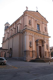
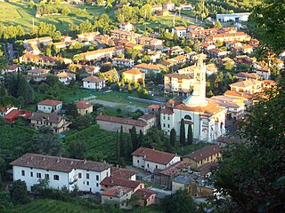
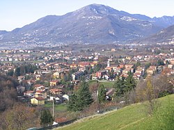
Ponteranica (Bergamasque: Potranga or Put de Ranga) is a comune (municipality) in the Province of Bergamo in the Italian region of Lombardy, located about 50 kilometres (31 mi) northeast of Milan and about 4 kilometres (2 mi) northwest of Bergamo. As of 31 December 2004, it had a population of 6,866 and an area of 8.4 square kilometres (3.2 sq mi). [1]

<i>Comune</i> third-level administrative divisions of the Italian Republic

The comune is a basic administrative division in Italy, roughly equivalent to a township or municipality.

Province of Bergamo Province of Italy

The Province of Bergamo is a province in the Lombardy region of Italy. It has a population of 1,112,187 (2017), an area of 2,754.91 square kilometers (1,063.68 sq mi), and contains 243 comuni. Its capital is the city of Bergamo.

Italy republic in Southern Europe

Italy, officially the Italian Republic, is a European country consisting of a peninsula delimited by the Italian Alps and surrounded by several islands. Located in the middle of the Mediterranean sea and traversed along its length by the Apennines, Italy has a largely temperate seasonal climate. The country covers an area of 301,340 km2 (116,350 sq mi) and shares open land borders with France, Slovenia, Austria, Switzerland and the enclaved microstates of Vatican City and San Marino. Italy has a territorial exclave in Switzerland (Campione) and a maritime exclave in the Tunisian sea (Lampedusa). With around 60 million inhabitants, Italy is the fourth-most populous member state of the European Union.

Contents

Ponteranica borders the following municipalities: Alzano Lombardo, Bergamo, Ranica, Sorisole, Torre Boldone, Zogno.

Alzano Lombardo Comune in Lombardy, Italy

Alzano Lombardo is a comune in the province of Bergamo, Lombardy, northern Italy.

Bergamo Comune in Lombardy, Italy

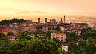
Bergamo is a city in the alpine Lombardy region of northern Italy, approximately 40 km (25 mi) northeast of Milan, and about 30 km (19 mi) from Switzerland, the alpine lakes Como and Iseo and 70 km (43 mi) from Garda and Maggiore. The Bergamo Alps begin immediately north of the city.

Ranica Comune in Lombardy, Italy

Ranica is a comune (municipality) in the Province of Bergamo in the Italian region of Lombardy, located about 50 kilometres (31 mi) northeast of Milan and about 5 kilometres (3 mi) northeast of Bergamo. As of 31 December 2004, it had a population of 5,984 and an area of 4.2 square kilometres (1.6 sq mi).

A part of is surfrace is occupied by Maresana Hill. The source of Morla is in Ponteranica.Part of Ponteranica's territory belonges of Parco dei Colli di Bergamo

Maresana Hill mountain

Maresana is a hill north of the city of Bergamo, in Lombardy, Italy. Its maximum elevation is 546 metres above sea level.

Morla river in Italy

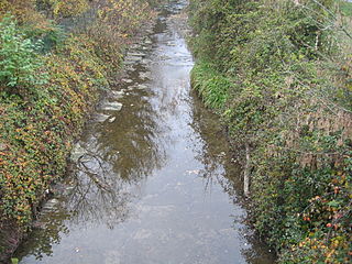
Morla is a 16 km long river in province of Bergamo. Its source is located in Maresana in the municipality of Ponteranica, then Morla crosses the city of Bergamo, after Bergamo part of its waters are used in agriculture. Morla wastes in Po Valley.

Parco dei Colli di Bergamo

Parco dei Colli di Bergamo is a natural park in the province of Bergamo, Lombardy, northern Italy.

Demographic evolution

Ponteranica

Related Research Articles

Arcene Comune in Lombardy, Italy

Arcene is a comune (municipality) in the Province of Bergamo in the Italian region of Lombardy, located about 35 kilometres (22 mi) northeast of Milan and about 14 kilometres (9 mi) southwest of Bergamo. As of 31 December 2004, it had a population of 4,529 and an area of 4.2 square kilometres (1.6 sq mi).

Aviatico Comune in Lombardy, Italy

Aviatico is a comune (municipality) in the Province of Bergamo in the Italian region of Lombardy, located about 60 kilometres (37 mi) northeast of Milan and about 12 kilometres (7 mi) northeast of Bergamo. As of 31 December 2007, it had a population of 515 and an area of 8.4 square kilometres (3.2 sq mi).

Colzate Comune in Lombardy, Italy

Colzate is a comune (municipality) in the Province of Bergamo in the Italian region of Lombardy, located about 70 kilometres (43 mi) northeast of Milan and about 20 kilometres (12 mi) northeast of Bergamo. As of 31 December 2004, it had a population of 1,638 and an area of 6.7 square kilometres (2.6 sq mi).

Fuipiano Valle Imagna Comune in Lombardy, Italy

Fuipiano Valle Imagna is a comune (municipality) in the Province of Bergamo in the Italian region of Lombardy, located about 50 kilometres (31 mi) northeast of Milan and about 20 kilometres (12 mi) northwest of Bergamo. As of 31 December 2004, it had a population of 238 and an area of 4.2 square kilometres (1.6 sq mi).

Gorle Comune in Lombardy, Italy

Gorle is a comune (municipality) in the Province of Bergamo in the Italian region of Lombardy, located about 50 kilometres (31 mi) northeast of Milan and about 4 kilometres (2 mi) east of Bergamo. As of 31 December 2004, it had a population of 5,506 and an area of 2.4 square kilometres (0.93 sq mi).

Martinengo (Italy) Comune in Lombardy, Italy

Martinengo is a comune (municipality) in the Province of Bergamo in the Italian region of Lombardy, located about 50 kilometres (31 mi) east of Milan and about 15 kilometres (9 mi) southeast of Bergamo. As of 31 December 2004, it had a population of 9,138 and an area of 21.7 square kilometres (8.4 sq mi).

Misano di Gera dAdda Comune in Lombardy, Italy

Misano di Gera d'Adda is a comune (municipality) in the Province of Bergamo in the Italian region of Lombardy, located about 35 kilometres (22 mi) east of Milan and about 25 kilometres (16 mi) south of Bergamo. As of 31 December 2004, it had a population of 2,877 and an area of 6.1 square kilometres (2.4 sq mi).

Mozzo Comune in Lombardy, Italy

Mozzo is a comune (municipality) in the Province of Bergamo in the Italian region of Lombardy, located about 45 kilometres (28 mi) northeast of Milan and about 5 kilometres (3 mi) west of Bergamo. As of 31 December 2004, it had a population of 7,202 and an area of 3.6 square kilometres (1.4 sq mi).

Parzanica Comune in Lombardy, Italy

Parzanica is a comune (municipality) in the Province of Bergamo in the Italian region of Lombardy, located about 70 kilometres (43 mi) northeast of Milan and about 30 kilometres (19 mi) east of Bergamo. As of 31 December 2004, it had a population of 365 and an area of 10.8 square kilometres (4.2 sq mi).

Scanzorosciate Comune in Lombardy, Italy

Scanzorosciate is a comune (municipality) in the Province of Bergamo in the Italian region of Lombardy, located about 50 kilometres (31 mi) northeast of Milan and about 6 kilometres (4 mi) northeast of Bergamo. As of 30 April 2013, it had a population of 10,018 and an area of 10.8 square kilometres (4.2 sq mi).

Seriate Comune in Lombardy, Italy

Seriate is a comune (municipality) in the Province of Bergamo in the Italian region of Lombardy, located about 50 kilometres (31 mi) northeast of Milan and about 4 kilometres (2 mi) southeast of Bergamo. As of 31 December 2010, it had a population of 24,297 and an area of 12.4 square kilometres (4.8 sq mi).

Sorisole Comune in Lombardy, Italy

Sorisole is a comune (municipality) in the Province of Bergamo in the Italian region of Lombardy, located about 50 kilometres (31 mi) northeast of Milan and about 4 kilometres (2 mi) north of Bergamo. As of 31 December 2004, it had a population of 8,507 and an area of 12.3 square kilometres (4.7 sq mi).

Tavernola Bergamasca Comune in Lombardy, Italy

Tavernola Bergamasca is a comune (municipality) in the Province of Bergamo in the Italian region of Lombardy, located about 70 kilometres (43 mi) northeast of Milan and about 30 kilometres (19 mi) east of Bergamo. As of 31 December 2004, it had a population of 2,242 and an area of 12.4 square kilometres (4.8 sq mi).

Torre Boldone Comune in Lombardy, Italy

Torre Boldone is a comune (municipality) in the Province of Bergamo in the Italian region of Lombardy, located about 50 kilometres (31 mi) northeast of Milan and about 3 kilometres (2 mi) northeast of Bergamo, at the entrance of the Valle Seriana. Part of Torre Boldone's territory is part of Parco dei Colli di Bergamo

Valbrembo Comune in Lombardy, Italy

Valbrembo is a comune (municipality) in the Province of Bergamo in the Italian region of Lombardy, located about 45 kilometres (28 mi) northeast of Milan and about 4 kilometres (2 mi) northwest of Bergamo. As of 31 December 2004, it had a population of 3,584 and an area of 3.7 square kilometres (1.4 sq mi).

Viadanica Comune in Lombardy, Italy

Viadanica is a comune (municipality) in the Province of Bergamo in the Italian region of Lombardy, located about 70 kilometres (43 mi) northeast of Milan and about 25 kilometres (16 mi) east of Bergamo. As of 31 December 2004, it had a population of 1,093 and an area of 5.4 square kilometres (2.1 sq mi).

Vigolo Comune in Lombardy, Italy

Vigolo is a comune (municipality) in the Province of Bergamo in the Italian region of Lombardy, located about 70 kilometres (43 mi) northeast of Milan and about 25 kilometres (16 mi) east of Bergamo. As of 31 December 2004, it had a population of 641 and an area of 12.2 square kilometres (4.7 sq mi).

Villa di Serio Comune in Lombardy, Italy

Villa di Serio is a comune (municipality) in the Province of Bergamo in the Italian region of Lombardy, located about 50 kilometres (31 mi) northeast of Milan and about 6 kilometres (4 mi) northeast of Bergamo. As of 31 December 2004, it had a population of 6,118 and an area of 4.6 square kilometres (1.8 sq mi).

Cornalba Comune in Lombardy, Italy

Cornalba is a comune (municipality) in the Province of Bergamo in the Italian region of Lombardy, located about 60 kilometres (37 mi) northeast of Milan and about 20 kilometres (12 mi) northeast of Bergamo. As of 31 December 2010, it had a population of 310 and an area of 9.4 square kilometres (3.6 sq mi).

References

  1. All demographics and other statistics: Italian statistical institute Istat.