Piazzolo

Last updated
Piazzolo
Comune
Comune di Piazzolo

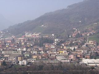
Piazzolo panorama.JPG

Piazzolo
Italy provincial location map 2015.svg
Red pog.svg
Piazzolo
Location of Piazzolo in Italy
Coordinates: 45°59′N9°40′E / 45.983°N 9.667°E / 45.983; 9.667 Coordinates: 45°59′N9°40′E / 45.983°N 9.667°E / 45.983; 9.667
Country Italy
Region Lombardy
Province Province of Bergamo (BG)
Area
  Total 4.2 km2 (1.6 sq mi)
Elevation 702 m (2,303 ft)
Population (Dec. 2004)
  Total 92
  Density 22/km2 (57/sq mi)
Demonym(s) Piazzolesi
Time zone CET (UTC+1)
  Summer (DST) CEST (UTC+2)
Postal code24010
Dialing code 0345

Piazzolo is a comune (municipality) in the Province of Bergamo in the Italian region of Lombardy, located about 70 kilometres (43 mi) northeast of Milan and about 30 kilometres (19 mi) north of Bergamo. As of 31 December 2004, it had a population of 92 and an area of 4.2 square kilometres (1.6 sq mi). [1]

<i>Comune</i> third-level administrative divisions of the Italian Republic

The comune is a basic administrative division in Italy, roughly equivalent to a township or municipality.

Province of Bergamo Province of Italy

The Province of Bergamo is a province in the Lombardy region of Italy. It has a population of 1,112,187 (2017), an area of 2,754.91 square kilometers (1,063.68 sq mi), and contains 243 comuni. Its capital is the city of Bergamo.

Italy republic in Southern Europe

Italy, officially the Italian Republic, is a European country consisting of a peninsula delimited by the Italian Alps and surrounded by several islands. Located in the middle of the Mediterranean sea and traversed along its length by the Apennines, Italy has a largely temperate seasonal climate. The country covers an area of 301,340 km2 (116,350 sq mi) and shares open land borders with France, Slovenia, Austria, Switzerland and the enclaved microstates of Vatican City and San Marino. Italy has a territorial exclave in Switzerland (Campione) and a maritime exclave in the Tunisian sea (Lampedusa). With around 60 million inhabitants, Italy is the fourth-most populous member state of the European Union.

Piazzolo borders the following municipalities: Mezzoldo, Moio de' Calvi, Olmo al Brembo, Piazza Brembana, Piazzatorre, Valnegra.

Mezzoldo Comune in Lombardy, Italy

Mezzoldo is a comune (municipality) in the Province of Bergamo in the Italian region of Lombardy, located about 70 kilometres (43 mi) northeast of Milan and about 35 kilometres (22 mi) north of Bergamo. As of 31 December 2004, it had a population of 225 and an area of 18.8 square kilometres (7.3 sq mi).

Moio de Calvi Comune in Lombardy, Italy

Moio de' Calvi is a comune (municipality) in the Province of Bergamo in the Italian region of Lombardy, located about 70 kilometres (43 mi) northeast of Milan and about 30 kilometres (19 mi) north of Bergamo.

Olmo al Brembo Comune in Lombardy, Italy

Olmo al Brembo is a comune (municipality) in the Province of Bergamo in the Italian region of Lombardy, located about 70 kilometres (43 mi) northeast of Milan and about 45 kilometres (28 mi) north of Bergamo.

In the cemetery is buried Guido Galli an Italian judge killed by the Red Brigades in the 1980s.

Red Brigades Italian militant group

The Red Brigades was a left-wing terrorist organization, based in Italy, responsible for numerous violent incidents, including assassinations, kidnapping and robberies during the so-called "Years of Lead".

Demographic evolution

Piazzolo

Related Research Articles

Antegnate Comune in Lombardy, Italy

Antegnate is a comune (municipality) in the Province of Bergamo in the Italian region of Lombardy, located about 50 kilometres (31 mi) east of Milan and about 25 kilometres (16 mi) southeast of Bergamo.

Aviatico Comune in Lombardy, Italy

Aviatico is a comune (municipality) in the Province of Bergamo in the Italian region of Lombardy, located about 60 kilometres (37 mi) northeast of Milan and about 12 kilometres (7 mi) northeast of Bergamo. As of 31 December 2007, it had a population of 515 and an area of 8.4 square kilometres (3.2 sq mi).

Boltiere Comune in Lombardy, Italy

Boltiere is a comune (municipality) in the Province of Bergamo in the Italian region of Lombardy, located about 35 kilometres (22 mi) northeast of Milan and about 13 kilometres (8 mi) southwest of Bergamo. As of 31 December 2004, it had a population of 4,695 and an area of 4.1 square kilometres (1.6 sq mi).

Brumano Comune in Lombardy, Italy

Brumano is a comune (municipality) in the Province of Bergamo in the Italian region of Lombardy, located about 50 kilometres (31 mi) northeast of Milan and about 20 kilometres (12 mi) northwest of Bergamo. As of 31 December 2004, it had a population of 96 and an area of 8.1 square kilometres (3.1 sq mi).

Colere Comune in Lombardy, Italy

Colere is a comune (municipality) in the Province of Bergamo in the Italian region of Lombardy, located about 90 kilometres (56 mi) northeast of Milan and about 45 kilometres (28 mi) northeast of Bergamo. As of 31 December 2004, it had a population of 1,147 and an area of 18.8 square kilometres (7.3 sq mi).

Colzate Comune in Lombardy, Italy

Colzate is a comune (municipality) in the Province of Bergamo in the Italian region of Lombardy, located about 70 kilometres (43 mi) northeast of Milan and about 20 kilometres (12 mi) northeast of Bergamo. As of 31 December 2004, it had a population of 1,638 and an area of 6.7 square kilometres (2.6 sq mi).

Ghisalba Comune in Lombardy, Italy

Ghisalba is a comune (municipality) in the Province of Bergamo in the Italian region of Lombardy, located about 50 kilometres (31 mi) northeast of Milan and about 13 kilometres (8 mi) southeast of Bergamo. As of 31 December 2010, it had a population of 5,967 and an area of 10.2 square kilometres (3.9 sq mi).

Gorle Comune in Lombardy, Italy

Gorle is a comune (municipality) in the Province of Bergamo in the Italian region of Lombardy, located about 50 kilometres (31 mi) northeast of Milan and about 4 kilometres (2 mi) east of Bergamo. As of 31 December 2004, it had a population of 5,506 and an area of 2.4 square kilometres (0.93 sq mi).

Lenna, Lombardy Comune in Lombardy, Italy

Lenna is a comune (municipality) in the Province of Bergamo in the Italian region of Lombardy, located about 70 kilometres (43 mi) northeast of Milan and about 30 kilometres (19 mi) north of Bergamo. As of 31 December 2004, it had a population of 676 and an area of 12.9 square kilometres (5.0 sq mi).

Misano di Gera dAdda Comune in Lombardy, Italy

Misano di Gera d'Adda is a comune (municipality) in the Province of Bergamo in the Italian region of Lombardy, located about 35 kilometres (22 mi) east of Milan and about 25 kilometres (16 mi) south of Bergamo. As of 31 December 2004, it had a population of 2,877 and an area of 6.1 square kilometres (2.4 sq mi).

Paladina Comune in Lombardy, Italy

Paladina is a comune (municipality) in the Province of Bergamo in the Italian region of Lombardy, located about 45 kilometres (28 mi) northeast of Milan and about 5 kilometres (3 mi) northwest of Bergamo.

Peia Comune in Lombardy, Italy

Peia is a comune (municipality) in the Province of Bergamo in the Italian region of Lombardy, located about 70 kilometres (43 mi) northeast of Milan and about 20 kilometres (12 mi) northeast of Bergamo. As of 31 December 2004, it had a population of 1,817 and an area of 4.4 square kilometres (1.7 sq mi).

Piario Comune in Lombardy, Italy

Piario is a comune (municipality) in the Province of Bergamo in the Italian region of Lombardy, located about 80 kilometres (50 mi) northeast of Milan and about 30 kilometres (19 mi) northeast of Bergamo. As of 31 December 2004, it had a population of 990 and an area of 1.5 square kilometres (0.58 sq mi).

Piazza Brembana Comune in Lombardy, Italy

Piazza Brembana is a comune (municipality) in the Province of Bergamo in the Italian region of Lombardy, located about 70 kilometres (43 mi) northeast of Milan and about 30 kilometres (19 mi) north of Bergamo.

Premolo Comune in Lombardy, Italy

Premolo is a comune (municipality) in the Province of Bergamo in the Italian region of Lombardy, located about 70 kilometres (43 mi) northeast of Milan and about 25 kilometres (16 mi) northeast of Bergamo. As of 31 December 2004, it had a population of 1,094 and an area of 18.3 square kilometres (7.1 sq mi).

Santa Brigida, Lombardy Comune in Lombardy, Italy

Santa Brigida is a comune (municipality) in the Province of Bergamo in the Italian region of Lombardy, located about 70 kilometres (43 mi) northeast of Milan and about 30 kilometres (19 mi) north of Bergamo. As of 31 December 2004, it had a population of 623 and an area of 14.2 square kilometres (5.5 sq mi).

Valnegra Comune in Lombardy, Italy

Valnegra is a comune (municipality) in the Province of Bergamo in the Italian region of Lombardy, located about 70 kilometres (43 mi) northeast of Milan and about 30 kilometres (19 mi) north of Bergamo. As of 31 December 2004, it had a population of 233 and an area of 2.1 square kilometres (0.81 sq mi).

Viadanica Comune in Lombardy, Italy

Viadanica is a comune (municipality) in the Province of Bergamo in the Italian region of Lombardy, located about 70 kilometres (43 mi) northeast of Milan and about 25 kilometres (16 mi) east of Bergamo. As of 31 December 2004, it had a population of 1,093 and an area of 5.4 square kilometres (2.1 sq mi).

Villa di Serio Comune in Lombardy, Italy

Villa di Serio is a comune (municipality) in the Province of Bergamo in the Italian region of Lombardy, located about 50 kilometres (31 mi) northeast of Milan and about 6 kilometres (4 mi) northeast of Bergamo. As of 31 December 2004, it had a population of 6,118 and an area of 4.6 square kilometres (1.8 sq mi).

References

  1. All demographics and other statistics: Italian statistical institute Istat.