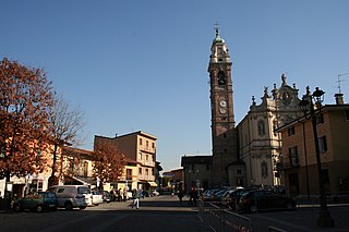
Chiuduno

Last updated
Chiuduno
Comune di Chiuduno
Chiuduno vista.jpg
Chiuduno
Chiuduno-Stemma.png
Coat of arms
Location of Chiuduno
Italy provincial location map 2015.svg
Red pog.svg
Chiuduno
Location of Chiuduno in Italy
Italy Lombardy location map.svg
Red pog.svg
Chiuduno
Chiuduno (Lombardy)
Coordinates: 45°39′N9°51′E / 45.650°N 9.850°E / 45.650; 9.850 Coordinates: 45°39′N9°51′E / 45.650°N 9.850°E / 45.650; 9.850
Country Italy
Region Lombardy
Province Bregamo (BG)
Government
  MayorStefano Locatelli (2011)
Area
  Total6.6 km2 (2.5 sq mi)
Elevation
218 m (715 ft)
Population
(Dec. 2004) [1]
  Total5,348
  Density810/km2 (2,100/sq mi)
Demonym(s) Chiudunesi
Time zone UTC+1 (CET)
  Summer (DST) UTC+2 (CEST)
Postal code
24060
Dialing code 035
Patron saintAssumption of Mary
Saint dayAugust, 15th

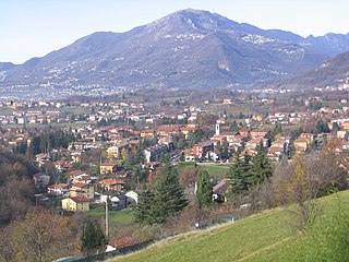
Chiuduno (Bergamasque: Ciüdü) is a comune (municipality) in the Province of Bergamo, in Italian region of Lombardy; Chiuduno is located about 60 kilometres (37 mi) northeast of Milan and about 15 kilometres (9 mi) southeast of Bergamo, midway between the Bergamo plain and the Valcalepio.

<i>Comune</i> third-level administrative divisions of the Italian Republic

The comune is a basic administrative division in Italy, roughly equivalent to a township or municipality.

Province of Bergamo Province of Italy

The Province of Bergamo is a province in the Lombardy region of Italy. It has a population of 1,112,187 (2017), an area of 2,754.91 square kilometers (1,063.68 sq mi), and contains 243 comuni. Its capital is the city of Bergamo.

Italy republic in Southern Europe

Italy, officially the Italian Republic, is a country in Southern and Western Europe. Located in the middle of the Mediterranean Sea, Italy shares open land borders with France, Switzerland, Austria, Slovenia and the enclaved microstates San Marino and Vatican City. Italy covers an area of 301,340 km2 (116,350 sq mi) and has a largely temperate seasonal and Mediterranean climate. With around 61 million inhabitants, it is the fourth-most populous EU member state and the most populous country in Southern Europe.

Contents

Chiuduno borders the following municipalities: Bolgare, Carobbio degli Angeli, Grumello del Monte, Telgate.

Bolgare Comune in Bergamo, Italy

Bolgare is a comune in the province of Bergamo, in Lombardy, Italy. It is situated in the plain between the rivers Serio and Oglio, 13 km southeast of Bergamo.

Carobbio degli Angeli Comune in Lombardy, Italy

Carobbio degli Angeli is a comune (municipality) in the Province of Bergamo in the Italian region of Lombardy, located about 60 kilometres (37 mi) northeast of Milan and about 13 kilometres (8 mi) southeast of Bergamo.

Grumello del Monte Comune in Lombardy, Italy

Grumello del Monte is a comune (municipality) of about 7,400 inhabitants in the province of Bergamo in the Italian region of Lombardy, located about 60 kilometres (37 mi) northeast of Milan and about 15 kilometres (9 mi) southeast of Bergamo.

History

The settlement has Gaulish origins, and was later a Roman centre as Claudunum on the road between Bergamo and Brescia. It is however mentioned for the first time in a document from 795, and in the Middle Ages it developed and received a fortress.

Gaul region of ancient Europe

Gaul was a historical region of Western Europe during the Iron Age that was inhabited by Celtic tribes, encompassing present day France, Luxembourg, Belgium, most of Switzerland, parts of Northern Italy, as well as the parts of the Netherlands and Germany on the west bank of the Rhine. It covered an area of 494,000 km2 (191,000 sq mi). According to the testimony of Julius Caesar, Gaul was divided into three parts: Gallia Celtica, Belgica, and Aquitania. Archaeologically, the Gauls were bearers of the La Tène culture, which extended across all of Gaul, as well as east to Raetia, Noricum, Pannonia, and southwestern Germania during the 5th to 1st centuries BC. During the 2nd and 1st centuries BC, Gaul fell under Roman rule: Gallia Cisalpina was conquered in 203 BC and Gallia Narbonensis in 123 BC. Gaul was invaded after 120 BC by the Cimbri and the Teutons, who were in turn defeated by the Romans by 103 BC. Julius Caesar finally subdued the remaining parts of Gaul in his campaigns of 58 to 51 BC.

Brescia Comune in Lombardy, Italy

Brescia is a city and comune in the region of Lombardy in northern Italy. It is situated at the foot of the Alps, a few kilometres from the lakes Garda and Iseo. With a population of about 200,000, it is the second largest city in the region and the fourth of northwest Italy. The urban area of Brescia extends beyond the administrative city limits and has a population of 672,822, while over 1.5 million people live in its metropolitan area. The city is the administrative capital of the Province of Brescia, one of the largest in Italy, with over 1,200,000 inhabitants.

Main sights

Demographic evolution

Chiuduno

Related Research Articles

Arzago dAdda Comune in Lombardy, Italy

Arzago d'Adda is a comune (municipality) in the Province of Bergamo in the Italian region of Lombardy, located about 30 kilometres (19 mi) east of Milan and about 25 kilometres (16 mi) southwest of Bergamo.

Canonica dAdda Comune in Lombardy, Italy

Canonica d'Adda is a comune (municipality) in the Province of Bergamo in the Italian region of Lombardy, located about 30 kilometres (19 mi) northeast of Milan and about 15 kilometres (9 mi) southwest of Bergamo.

Cavernago Comune in Lombardy, Italy

Cavernago is a comune (municipality) in the Province of Bergamo in the Italian region of Lombardy, located about 50 kilometres (31 mi) northeast of Milan and about 11 kilometres (7 mi) southeast of Bergamo.

Cene Comune in Lombardy, Italy

Cene is a comune (municipality) in the Province of Bergamo in the Italian region of Lombardy, located about 60 kilometres (37 mi) northeast of Milan and about 15 kilometres (9 mi) northeast of Bergamo.

Dossena Comune in Lombardy, Italy

Dossena is a comune (municipality) in the Province of Bergamo in the Italian region of Lombardy, located about 60 kilometres (37 mi) northeast of Milan and about 20 kilometres (12 mi) north of Bergamo.

Gandosso Comune in Lombardy, Italy

Gandosso is a comune (municipality) in the Province of Bergamo in the Italian region of Lombardy, located about 60 kilometres (37 mi) northeast of Milan and about 20 kilometres (12 mi) southeast of Bergamo.

Gorlago Comune in Lombardy, Italy

Gorlago is a comune (municipality) in the Province of Bergamo in the Italian region of Lombardy, located about 60 kilometres (37 mi) northeast of Milan and about 12 kilometres (7 mi) southeast of Bergamo.

Nembro Comune in Lombardy, Italy

Nembro is a comune (municipality) in the Province of Bergamo in the Italian region of Lombardy, located about 60 kilometres (37 mi) northeast of Milan and about 10 kilometres (6 mi) northeast of Bergamo, on the right bank of the Serio River.

Osio Sotto Comune in Lombardy, Italy

Osio Sotto is a comune (municipality) in the Province of Bergamo in the Italian region of Lombardy, located about 40 kilometres (25 mi) northeast of Milan and about 11 kilometres (7 mi) southwest of Bergamo. As of 31 December 2004, it had a population of 11,097 and an area of 7.5 square kilometres (2.9 sq mi).

Piazzatorre Comune in Lombardy, Italy

Piazzatorre is a comune (municipality) in the Province of Bergamo in the Italian region of Lombardy, located about 70 kilometres (43 mi) northeast of Milan and about 35 kilometres (22 mi) north of Bergamo. As of 31 December 2004, it had a population of 475 and an area of 23.6 square kilometres (9.1 sq mi).

Ponteranica Comune in Lombardy, Italy

Ponteranica is a comune (municipality) in the Province of Bergamo in the Italian region of Lombardy, located about 50 kilometres (31 mi) northeast of Milan and about 4 kilometres (2 mi) northwest of Bergamo. As of 31 December 2004, it had a population of 6,866 and an area of 8.4 square kilometres (3.2 sq mi).

Spinone al Lago Comune in Lombardy, Italy

Spinone al Lago is a comune (municipality) in the Province of Bergamo in the Italian region of Lombardy, located about 70 kilometres (43 mi) northeast of Milan and about 20 kilometres (12 mi) northeast of Bergamo, on the left bank of the Lake Endine.

Telgate Comune in Lombardy, Italy

Telgate is a comune (municipality) in the Province of Bergamo in the Italian region of Lombardy, located about 60 kilometres (37 mi) northeast of Milan and about 15 kilometres (9 mi) southeast of Bergamo. As of 31 December 2004, it had a population of 4,598 and an area of 8.1 square kilometres (3.1 sq mi).

Ubiale Clanezzo Comune in Lombardy, Italy

Ubiale Clanezzo is a comune (municipality) in the Province of Bergamo in the Italian region of Lombardy, located about 50 kilometres (31 mi) northeast of Milan and about 10 kilometres (6 mi) northwest of Bergamo.

Zogno Comune in Lombardy, Italy

Zogno is a comune (municipality) in the Province of Bergamo in the Italian region of Lombardy, located about 50 kilometres (31 mi) northeast of Milan and about 11 kilometres (7 mi) north of Bergamo.

Motta dAffermo Comune in Sicily, Italy

Motta d'Affermo is a comune (municipality) in the Province of Messina in the Italian region Sicily, located about 80 kilometres (50 mi) east of Palermo and about 110 kilometres (68 mi) west of Messina.

Perfugas Comune in Sardinia, Italy

Perfugas is a comune (municipality) in the Province of Sassari in the Italian region Sardinia, located about 180 kilometres (110 mi) north of Cagliari and about 30 kilometres (19 mi) northeast of Sassari.

References

  1. All demographics and other statistics: Italian statistical institute Istat.