Oltressenda Alta

Last updated
Oltressenda Alta
Comune di Oltressenda Alta
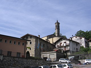
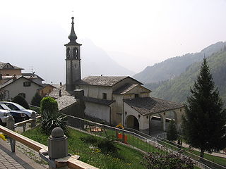
Nasolino SBernardo church 02.jpg
Church
Location of Oltressenda Alta
Italy provincial location map 2015.svg
Red pog.svg
Oltressenda Alta
Location of Oltressenda Alta in Italy
Italy Lombardy location map.svg
Red pog.svg
Oltressenda Alta
Oltressenda Alta (Lombardy)
Coordinates: 45°55′N9°56′E / 45.917°N 9.933°E / 45.917; 9.933 Coordinates: 45°55′N9°56′E / 45.917°N 9.933°E / 45.917; 9.933
Country Italy
Region Lombardy
Province Province of Bergamo (BG)
Area
  Total17.3 km2 (6.7 sq mi)
Elevation
714 m (2,343 ft)
Population
(Dec. 2004)
  Total195
  Density11/km2 (29/sq mi)
Demonym(s) Nasolinensi
Time zone UTC+1 (CET)
  Summer (DST) UTC+2 (CEST)
Postal code
24020
Dialing code 0346
aerial view of Oltressanda Alta Oltressenda Alta Valzurio.JPG
aerial view of Oltressanda Alta

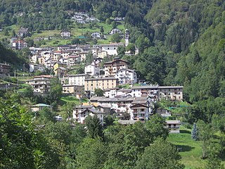
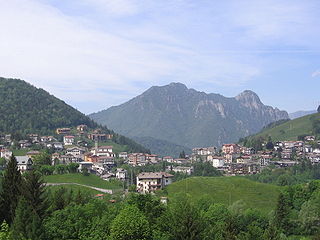
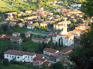
Oltressenda Alta (Bergamasque: Oltressènda Ólta) is a comune (municipality) in the Province of Bergamo in the Italian region of Lombardy, located about 80 kilometres (50 mi) northeast of Milan and about 30 kilometres (19 mi) northeast of Bergamo. As of 31 December 2004, it had a population of 195 and an area of 17.3 square kilometres (6.7 sq mi). [1]

<i>Comune</i> third-level administrative divisions of the Italian Republic

The comune is a basic administrative division in Italy, roughly equivalent to a township or municipality.

Province of Bergamo Province of Italy

The Province of Bergamo is a province in the Lombardy region of Italy. It has a population of 1,112,187 (2017), an area of 2,754.91 square kilometers (1,063.68 sq mi), and contains 243 comuni. Its capital is the city of Bergamo.

Italy republic in Southern Europe

Italy, officially the Italian Republic, is a European country consisting of a peninsula delimited by the Italian Alps and sorrounded by several islands. Located in the middle of the Mediterranean sea and traversed along its lenght by the Apennines, Italy has a largely temperate seasonal climate. The country covers an area of 301,340 km2 (116,350 sq mi) and shares open land borders with France, Slovenia, Austria, Switzerland and the enclaved microstates of Vatican City and San Marino. Italy has a territorial exclave in Switzerland (Campione) and a maritime exclave in the Tunisian sea (Lampedusa). With around 60 million inhabitants, Italy is the fourth-most populous member state of the European Union.

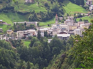
Oltressenda Alta borders the following municipalities: Ardesio, Clusone, Gromo, Rovetta, Villa d'Ogna, Vilminore di Scalve, Oltressenda alta has two majority localities: Nasolino and Valzurio.

Ardesio Comune in Lombardy, Italy

Ardesio is a comune in the province of Bergamo, in Lombardy, Italy.

Clusone Comune in Lombardy, Italy

Clusone is an Italian town and comune in the province of Bergamo, Lombardy, Italy. Located in the Val Seriana, it received the honorary title of city on 15 May 1957 with a presidential decree which ratified a Napoleon's promise of the year 1801.

Gromo Comune in Lombardy, Italy

Gromo is a comune (municipality) in the Province of Bergamo in the Italian region of Lombardy, located about 80 kilometres (50 mi) northeast of Milan and about 35 kilometres (22 mi) northeast of Bergamo. As of 31 December 2004, it had a population of 1,246 and an area of 20.0 square kilometres (7.7 sq mi).

Demographic evolution

Oltressenda Alta

Related Research Articles

Aviatico Comune in Lombardy, Italy

Aviatico is a comune (municipality) in the Province of Bergamo in the Italian region of Lombardy, located about 60 kilometres (37 mi) northeast of Milan and about 12 kilometres (7 mi) northeast of Bergamo. As of 31 December 2007, it had a population of 515 and an area of 8.4 square kilometres (3.2 sq mi).

Azzone Comune in Lombardy, Italy

Azzone is a comune (municipality) in the Province of Bergamo in the Italian region of Lombardy, located about 90 kilometres (56 mi) northeast of Milan and about 45 kilometres (28 mi) northeast of Bergamo. As of 31 December 2004, it had a population of 458 and an area of 16.8 square kilometres (6.5 sq mi).

Bracca Comune in Lombardy, Italy

Bracca is a comune (municipality) in the Province of Bergamo in the Italian region of Lombardy, located about 60 kilometres (37 mi) northeast of Milan and about 14 kilometres (9 mi) northeast of Bergamo. As of 31 December 2004, it had a population of 827 and an area of 5.5 square kilometres (2.1 sq mi).

Colere Comune in Lombardy, Italy

Colere is a comune (municipality) in the Province of Bergamo in the Italian region of Lombardy, located about 90 kilometres (56 mi) northeast of Milan and about 45 kilometres (28 mi) northeast of Bergamo. As of 31 December 2004, it had a population of 1,147 and an area of 18.8 square kilometres (7.3 sq mi).

Colzate Comune in Lombardy, Italy

Colzate is a comune (municipality) in the Province of Bergamo in the Italian region of Lombardy, located about 70 kilometres (43 mi) northeast of Milan and about 20 kilometres (12 mi) northeast of Bergamo. As of 31 December 2004, it had a population of 1,638 and an area of 6.7 square kilometres (2.6 sq mi).

Cusio, Lombardy Comune in Lombardy, Italy

Cusio is a comune (municipality) in the Province of Bergamo in the Italian region of Lombardy, and is located about 70 kilometres (43 mi) northeast of Milan and about 30 kilometres (19 mi) north of Bergamo. As of 31 December 2004, it had a population of 286 and an area of 9.3 square kilometres (3.6 sq mi).

Gandellino Comune in Lombardy, Italy

Gandellino is a comune (municipality) in the Province of Bergamo in the Italian region of Lombardy, located about 90 kilometres (56 mi) northeast of Milan and about 40 kilometres (25 mi) northeast of Bergamo.

Oltre il Colle Comune in Lombardy, Italy

Oltre il Colle is a comune (municipality) in the Province of Bergamo in the Italian region of Lombardy, located about 70 kilometres (43 mi) northeast of Milan and about 20 kilometres (12 mi) northeast of Bergamo. As of 31 December 2004, it had a population of 1,114 and an area of 32.4 square kilometres (12.5 sq mi).

Ornica Comune in Lombardy, Italy

Ornica is a comune (municipality) in the Province of Bergamo in the Italian region of Lombardy, located about 70 kilometres (43 mi) northeast of Milan and about 30 kilometres (19 mi) north of Bergamo, at the foot of the Pizzo Tre Signori.

Paladina Comune in Lombardy, Italy

Paladina is a comune (municipality) in the Province of Bergamo in the Italian region of Lombardy, located about 45 kilometres (28 mi) northeast of Milan and about 5 kilometres (3 mi) northwest of Bergamo.

Rovetta Comune in Lombardy, Italy

Rovetta is a comune (municipality) in the Province of Bergamo in the Italian region of Lombardy, located about 80 kilometres (50 mi) northeast of Milan and about 30 kilometres (19 mi) northeast of Bergamo. As of 31 December 2004, it had a population of 3,611 and an area of 24.0 square kilometres (9.3 sq mi).

Santa Brigida, Lombardy Comune in Lombardy, Italy

Santa Brigida is a comune (municipality) in the Province of Bergamo in the Italian region of Lombardy, located about 70 kilometres (43 mi) northeast of Milan and about 30 kilometres (19 mi) north of Bergamo. As of 31 December 2004, it had a population of 623 and an area of 14.2 square kilometres (5.5 sq mi).

Scanzorosciate Comune in Lombardy, Italy

Scanzorosciate is a comune (municipality) in the Province of Bergamo in the Italian region of Lombardy, located about 50 kilometres (31 mi) northeast of Milan and about 6 kilometres (4 mi) northeast of Bergamo. As of 30 April 2013, it had a population of 10,018 and an area of 10.8 square kilometres (4.2 sq mi).

Valbondione Comune in Lombardy, Italy

Valbondione is a comune (municipality) in the Province of Bergamo in the Italian region of Lombardy, located about 90 kilometres (56 mi) northeast of Milan and about 45 kilometres (28 mi) north of Bergamo. As of 31 December 2004, it had a population of 1,156 and an area of 95.0 square kilometres (36.7 sq mi).

Valgoglio Comune in Lombardy, Italy

Valgoglio is a comune (municipality) in the Province of Bergamo in the Italian region of Lombardy, located about 80 kilometres (50 mi) northeast of Milan and about 35 kilometres (22 mi) northeast of Bergamo.

Valtorta, Lombardy Comune in Lombardy, Italy

Valtorta is a comune (municipality) in the Province of Bergamo in the Italian region of Lombardy, located about 60 kilometres (37 mi) northeast of Milan and about 35 kilometres (22 mi) northwest of Bergamo.

Villa di Serio Comune in Lombardy, Italy

Villa di Serio is a comune (municipality) in the Province of Bergamo in the Italian region of Lombardy, located about 50 kilometres (31 mi) northeast of Milan and about 6 kilometres (4 mi) northeast of Bergamo. As of 31 December 2004, it had a population of 6,118 and an area of 4.6 square kilometres (1.8 sq mi).

Villa dOgna Comune in Lombardy, Italy

Villa d'Ogna is a comune (municipality) in the Province of Bergamo in the Italian region of Lombardy, located about 80 kilometres (50 mi) northeast of Milan and about 30 kilometres (19 mi) northeast of Bergamo. As of 31 December 2004, it had a population of 1,891 and an area of 5.2 square kilometres (2.0 sq mi).

Vilminore di Scalve Comune in Lombardy, Italy

Vilminore di Scalve is a comune (municipality) in the Province of Bergamo in the Italian region of Lombardy, located about 90 kilometres (56 mi) northeast of Milan and about 45 kilometres (28 mi) northeast of Bergamo. As of 31 December 2010, it had a population of 1,532 and an area of 40.9 square kilometres (15.8 sq mi).

References

  1. All demographics and other statistics: Italian statistical institute Istat.