Ostiano

Last updated
Ostiano
Üstià  (Lombard)
Comune
Comune di Ostiano
Italy provincial location map 2015.svg
Red pog.svg
Ostiano
Location of Ostiano in Italy
Coordinates: 45°13′N10°15′E / 45.217°N 10.250°E / 45.217; 10.250 Coordinates: 45°13′N10°15′E / 45.217°N 10.250°E / 45.217; 10.250
Country Italy
Region Lombardy
Province Province of Cremona (CR)
Area
  Total 19.4 km2 (7.5 sq mi)
Population (Dec. 2004)
  Total 3,054
  Density 160/km2 (410/sq mi)
Time zone CET (UTC+1)
  Summer (DST) CEST (UTC+2)
Postal code26032
Dialing code 0372
Website Official website

Ostiano (Brescian: Üstià) is a comune (municipality) in the Province of Cremona in the Italian region Lombardy, located about 90 kilometres (56 mi) southeast of Milan and about 20 kilometres (12 mi) northeast of Cremona. As of 31 December 2004, it had a population of 3,054 and an area of 19.4 square kilometres (7.5 sq mi). [1]

<i>Comune</i> third-level administrative divisions of the Italian Republic

The comune is a basic administrative division in Italy, roughly equivalent to a township or municipality.

Province of Cremona Province of Italy

The Province of Cremona is a province in the Lombardy region of Italy. Its capital city is Cremona.

Italy republic in Southern Europe

Italy, officially the Italian Republic, is a European country consisting of a peninsula delimited by the Italian Alps and sorrounded by several islands. Located in the middle of the Mediterranean sea and traversed along its lenght by the Apennines, Italy has a largely temperate seasonal climate. The country covers an area of 301,340 km2 (116,350 sq mi) and shares open land borders with France, Slovenia, Austria, Switzerland and the enclaved microstates of Vatican City and San Marino. Italy has a territorial exclave in Switzerland (Campione) and a maritime exclave in the Tunisian sea (Lampedusa). With around 60 million inhabitants, Italy is the fourth-most populous member state of the European Union.

Contents

Ostiano borders the following municipalities: Gabbioneta-Binanuova, Gambara, Pessina Cremonese, Pralboino, Seniga, Volongo.

Gabbioneta-Binanuova Comune in Lombardy, Italy

Gabbioneta-Binanuova is a comune (municipality) in the Province of Cremona in the Italian region Lombardy, located about 90 kilometres (56 mi) southeast of Milan and about 15 kilometres (9 mi) northeast of Cremona.

Gambara Comune in Lombardy, Italy

Gambara is a town and comune in the province of Brescia, in Lombardy. Bordering communes are Asola (MN), Fiesse, Gottolengo, Isorella, Ostiano (CR), Pralboino, Remedello and Volongo (CR).

Pessina Cremonese Comune in Lombardy, Italy

Pessina Cremonese is a comune (municipality) in the Province of Cremona in the Italian region Lombardy, located about 90 kilometres (56 mi) southeast of Milan and about 20 kilometres (12 mi) northeast of Cremona.

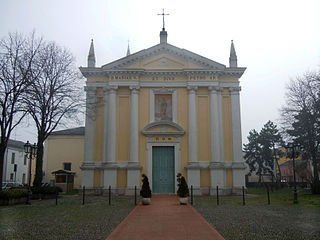
Among the churches in the territory are:

The Oratorio dei Disciplini is a Roman Catholic oratory, or small church, located in Ostiano in the province of Cremona, region of Lombardy, Italy.

The Pieve di San Gaudenzio is a Roman Catholic church, located in Ostiano in the province of Cremona, region of Lombardy, Italy.

San Michele Arcangelo is a Roman Catholic parish church located on in the town of Ostiano in the province of Cremona, region of Lombardy, Italy.

Demographic evolution

Ostiano

Related Research Articles

Casteldidone Comune in Lombardy, Italy

Casteldidone is a comune (municipality) in the Province of Cremona in the Italian region Lombardy, located about 110 kilometres (68 mi) southeast of Milan and about 30 kilometres (19 mi) east of Cremona.

Castelleone Comune in Lombardy, Italy

Castelleone is a comune (municipality) in the Province of Cremona in the Italian region of Lombardy, located about 50 kilometres (31 mi) southeast of Milan and about 30 kilometres (19 mi) northwest of Cremona.

Cicognolo Comune in Lombardy, Italy

Cicognolo is a comune (municipality) in the Province of Cremona in the Italian region Lombardy, located about 90 kilometres (56 mi) southeast of Milan and about 14 kilometres (9 mi) northeast of Cremona. As of 31 December 2012, it had a population of 961 and an area of 7.0 square kilometres (2.7 sq mi).

Grontardo Comune in Lombardy, Italy

Grontardo is a comune (municipality) in the Province of Cremona in the Italian region Lombardy, located about 80 kilometres (50 mi) southeast of Milan and about 12 kilometres (7 mi) northeast of Cremona.

Gussola Comune in Lombardy, Italy

Gussola is a comune (municipality) in the Province of Cremona in the Italian region Lombardy, located about 110 kilometres (68 mi) southeast of Milan and about 30 kilometres (19 mi) southeast of Cremona.

Izano Comune in Lombardy, Italy

Izano is a comune (municipality) in the Province of Cremona in the Italian region of Lombardy, located about 45 kilometres (28 mi) southeast of Milan and about 35 kilometres (22 mi) northwest of Cremona.

Martignana di Po Comune in Lombardy, Italy

Martignana di Po is a comune (municipality) in the Province of Cremona in the Italian region Lombardy, located about 110 kilometres (68 mi) southeast of Milan and about 30 kilometres (19 mi) southeast of Cremona.

Moscazzano Comune in Lombardy, Italy

Moscazzano is a comune (municipality) in the Province of Cremona in the Italian region Lombardy, located about 45 kilometres (28 mi) southeast of Milan and about 30 kilometres (19 mi) northwest of Cremona.

Persico Dosimo Comune in Lombardy, Italy

Persico Dosimo is a comune (municipality) in the Province of Cremona in the Italian region Lombardy, located about 80 kilometres (50 mi) southeast of Milan and about 8 kilometres (5 mi) northeast of Cremona.

Pieve San Giacomo Comune in Lombardy, Italy

Pieve San Giacomo is a comune (municipality) in the Province of Cremona in the Italian region Lombardy, located about 90 kilometres (56 mi) southeast of Milan and about 12 kilometres (7.5 mi) east of Cremona.

Rivolta dAdda Comune in Lombardy, Italy

Rivolta d'Adda is a comune (municipality) in the Province of Cremona in the Italian region Lombardy, located about 25 kilometres (16 mi) east of Milan and about 70 kilometres (43 mi) northwest of Cremona.

San Bassano Comune in Lombardy, Italy

San Bassano is a comune (municipality) in the Province of Cremona in the Italian region Lombardy, located about 60 kilometres (37 mi) southeast of Milan and about 20 kilometres (12 mi) northwest of Cremona.

San Daniele Po Comune in Lombardy, Italy

San Daniele Po is a comune in the Province of Cremona in the Italian region Lombardy, located about 90 kilometres (56 mi) southeast of Milan and about 14 kilometres (9 mi) southeast of Cremona.

San Martino del Lago Comune in Lombardy, Italy

San Martino del Lago is a comune (municipality) in the Province of Cremona in the Italian region Lombardy, located about 100 kilometres (62 mi) southeast of Milan and about 25 kilometres (16 mi) southeast of Cremona.

Scandolara Ravara Comune in Lombardy, Italy

Scandolara Ravara is a comune (municipality) in the Province of Cremona in the Italian region Lombardy, located about 100 kilometres (62 mi) southeast of Milan and about 20 kilometres (12 mi) southeast of Cremona.

Solarolo Rainerio Comune in Lombardy, Italy

Solarolo Rainerio is a comune (municipality) in the Province of Cremona in the Italian region Lombardy, located about 100 kilometres (62 mi) southeast of Milan and about 25 kilometres (16 mi) east of Cremona. As of 31 December 2004, it had a population of 1,016 and an area of 11.4 square kilometres (4.4 sq mi).

Sospiro Comune in Lombardy, Italy

Sospiro is a comune (municipality) in the Province of Cremona in the Italian region Lombardy, located about 90 kilometres (56 mi) southeast of Milan and about 10 kilometres (6 mi) southeast of Cremona.

Volongo Comune in Lombardy, Italy

Volongo is a comune (municipality) in the Province of Cremona in the Italian region Lombardy, located about 90 kilometres (56 mi) southeast of Milan and about 25 kilometres (16 mi) northeast of Cremona.

References

  1. All demographics and other statistics: Italian statistical institute Istat.