Vailate

Last updated
Vailate
Aliàt  (Lombard)
Comune
Comune di Vailate
Italy provincial location map 2015.svg
Red pog.svg
Vailate
Location of Vailate in Italy
Coordinates: 45°28′N9°36′E / 45.467°N 9.600°E / 45.467; 9.600 Coordinates: 45°28′N9°36′E / 45.467°N 9.600°E / 45.467; 9.600
Country Italy
Region Lombardy
Province Province of Cremona (CR)
Area
  Total 9.8 km2 (3.8 sq mi)
Population (Dec. 2004)
  Total 4,299
  Density 440/km2 (1,100/sq mi)
Time zone CET (UTC+1)
  Summer (DST) CEST (UTC+2)
Postal code26019
Dialing code +390363
Website Official website

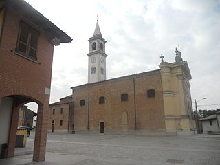
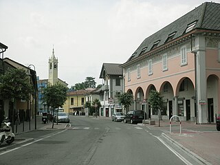
Vailate (Cremasco: Aliàt) is a comune (municipality) in the Province of Cremona in the Italian region Lombardy, located about 35 kilometres (22 mi) east of Milan and about 50 kilometres (31 mi) northwest of Cremona. As of 31 December 2004, it had a population of 4,299 and an area of 9.8 square kilometres (3.8 sq mi). [1]

<i>Comune</i> third-level administrative divisions of the Italian Republic

The comune is a basic administrative division in Italy, roughly equivalent to a township or municipality.

Province of Cremona Province of Italy

The Province of Cremona is a province in the Lombardy region of Italy. Its capital city is Cremona.

Italy republic in Southern Europe

Italy, officially the Italian Republic, is a country in Southern Europe. Located in the middle of the Mediterranean Sea, Italy shares open land borders with France, Switzerland, Austria, Slovenia and the enclaved microstates San Marino and Vatican City. Italy covers an area of 301,340 km2 (116,350 sq mi) and has a largely temperate seasonal and Mediterranean climate. With around 61 million inhabitants, it is the fourth-most populous EU member state and the most populous country in Southern Europe.

Contents

Vailate borders the following municipalities: Agnadello, Arzago d'Adda, Calvenzano, Capralba, Misano di Gera d'Adda, Torlino Vimercati.

Agnadello Comune in Lombardy, Italy

Agnadello is a comune and village in the province of Cremona, Lombardy, northern Italy. It was the location of the battle of Agnadello in which Louis XII of France defeated the Venetians on 14 May 1509.

Arzago dAdda Comune in Lombardy, Italy

Arzago d'Adda is a comune (municipality) in the Province of Bergamo in the Italian region of Lombardy, located about 30 kilometres (19 mi) east of Milan and about 25 kilometres (16 mi) southwest of Bergamo.

Calvenzano Comune in Lombardy, Italy

Calvenzano is a comune (municipality) in the Province of Bergamo in the Italian region of Lombardy, located about 35 kilometres (22 mi) east of Milan and about 25 kilometres (16 mi) south of Bergamo. As of 31 December 2004, it had a population of 3,618 and an area of 6.5 square kilometres (2.5 sq mi).

Demographic evolution

Vailate

Related Research Articles

Fara Gera dAdda Comune in Lombardy, Italy

Fara Gera d'Adda is a comune (municipality) in the Province of Bergamo in the Italian region of Lombardy, located about 30 kilometres (19 mi) northeast of Milan and about 20 kilometres (12 mi) southwest of Bergamo. As of 31 December 2004, it had a population of 7,396 and an area of 10.6 square kilometres (4.1 sq mi).

Misano di Gera dAdda Comune in Lombardy, Italy

Misano di Gera d'Adda is a comune (municipality) in the Province of Bergamo in the Italian region of Lombardy, located about 35 kilometres (22 mi) east of Milan and about 25 kilometres (16 mi) south of Bergamo. As of 31 December 2004, it had a population of 2,877 and an area of 6.1 square kilometres (2.4 sq mi).

Medolago Comune in Lombardy, Italy

Medolago is a comune (municipality) in the Province of Bergamo in the Italian region of Lombardy, located about 35 kilometres (22 mi) northeast of Milan and about 14 kilometres (9 mi) southwest of Bergamo. As of 31 December 2004, it had a population of 2,231 and an area of 3.8 square kilometres (1.5 sq mi).

Acquanegra Cremonese Comune in Lombardy, Italy

Acquanegra Cremonese is a comune (municipality) in the Province of Cremona in the Italian region Lombardy, located about 70 kilometres (43 mi) southeast of Milan and about 12 kilometres (7 mi) northwest of Cremona.

Capralba Comune in Lombardy, Italy

Capralba is a comune (municipality) in the Province of Cremona in the Italian region Lombardy, located about 40 kilometres (25 mi) east of Milan and about 45 kilometres (28 mi) northwest of Cremona.

Casaletto Ceredano Comune in Lombardy, Italy

Casaletto Ceredano is a comune (municipality) in the Province of Cremona in the Italian region Lombardy, located about 40 kilometres (25 mi) southeast of Milan and about 40 kilometres (25 mi) northwest of Cremona.

Credera Rubbiano Comune in Lombardy, Italy

Credera Rubbiano is a comune (municipality) in the Province of Cremona in the Italian region Lombardy, located about 45 kilometres (28 mi) southeast of Milan and about 35 kilometres (22 mi) northwest of Cremona. It was created in 1928 through the merger of the former communes of Credera and Rubbiano.

Crotta dAdda Comune in Lombardy, Italy

Crotta d'Adda is a comune (municipality) in the Province of Cremona in the Italian region Lombardy, located about 60 kilometres (37 mi) southeast of Milan and about 15 kilometres (9.3 mi) west of Cremona.

Dovera Comune in Lombardy, Italy

Dovera is a comune (municipality) in the Province of Cremona in the Italian region Lombardy, located about 30 kilometres (19 mi) southeast of Milan and about 45 kilometres (28 mi) northwest of Cremona.

Formigara Comune in Lombardy, Italy

Formigara is a comune (municipality) in the Province of Cremona in the Italian region Lombardy, located about 50 kilometres (31 mi) southeast of Milan and about 25 kilometres (16 mi) northwest of Cremona.

Gombito Comune in Lombardy, Italy

Gombito is a comune (municipality) in the Province of Cremona in the Italian region Lombardy, located about 50 kilometres (31 mi) southeast of Milan and about 30 kilometres (19 mi) northwest of Cremona.

Grumello Cremonese ed Uniti Comune in Lombardy, Italy

Grumello Cremonese ed Uniti is a comune (municipality) in the Province of Cremona in the Italian region Lombardy, located about 60 kilometres (37 mi) southeast of Milan and about 15 kilometres (9.3 mi) northwest of Cremona. Grumello Cremonese ed Uniti borders the following municipalities: Acquanegra Cremonese, Annicco, Cappella Cantone, Crotta d'Adda, Pizzighettone, Sesto ed Uniti.

Pandino Comune in Lombardy, Italy

Pandino is a comune (municipality) in the Province of Cremona in the Italian region Lombardy, located about 30 kilometres (19 mi) east of Milan and about 50 kilometres (31 mi) northwest of Cremona.

Rivolta dAdda Comune in Lombardy, Italy

Rivolta d'Adda is a comune (municipality) in the Province of Cremona in the Italian region Lombardy, located about 25 kilometres (16 mi) east of Milan and about 70 kilometres (43 mi) northwest of Cremona.

Spinadesco Comune in Lombardy, Italy

Spinadesco is a comune (municipality) in the Province of Cremona in the Italian region Lombardy, located about 70 kilometres (43 mi) southeast of Milan and about 8 kilometres (5 mi) west of Cremona.

Spino dAdda Comune in Lombardy, Italy

Spino d'Adda is a comune (municipality) in the Province of Cremona in the Italian region Lombardy, located about 25 kilometres (16 mi) southeast of Milan and about 50 kilometres (31 mi) northwest of Cremona.

Torlino Vimercati Comune in Lombardy, Italy

Torlino Vimercati is a comune (municipality) in the Province of Cremona in the Italian region Lombardy, located about 35 kilometres (22 mi) east of Milan and about 45 kilometres (28 mi) northwest of Cremona.

Caorso Comune in Emilia-Romagna, Italy

Caorso is a comune (municipality) in the Province of Piacenza in the Italian region Emilia-Romagna, located about 130 kilometres (81 mi) northwest of Bologna and about 13 kilometres (8 mi) east of Piacenza.

References

  1. All demographics and other statistics: Italian statistical institute Istat.