Credera Rubbiano

Last updated
Credera Rubbiano
Credéra Rübià  (Lombard)
Comune
Comune di Credera Rubbiano
Credera piazza.JPG
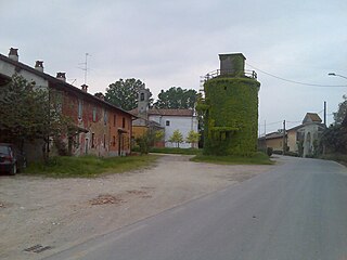
A square in Credera Rubbiano.
Italy provincial location map 2015.svg
Red pog.svg
Credera Rubbiano
Location of Credera Rubbiano in Italy
Coordinates: 45°18′N9°40′E / 45.300°N 9.667°E / 45.300; 9.667 Coordinates: 45°18′N9°40′E / 45.300°N 9.667°E / 45.300; 9.667
Country Italy
Region Lombardy
Province Cremona (CR)
Government
  Mayor Matteo Guerini Rocco
Area
  Total 14.4 km2 (5.6 sq mi)
Elevation 69 m (226 ft)
Population (30 June 2017) [1]
  Total 1,605
  Density 110/km2 (290/sq mi)
Demonym(s) Crederesi
Time zone CET (UTC+1)
  Summer (DST) CEST (UTC+2)
Postal code26010
Dialing code 0373
Website Official website

Credera Rubbiano (Cremasco: Credéra Rübià) is a comune (municipality) in the Province of Cremona in the Italian region Lombardy, located about 45 kilometres (28 mi) southeast of Milan and about 35 kilometres (22 mi) northwest of Cremona. It was created in 1928 through the merger of the former communes of Credera and Rubbiano.

<i>Comune</i> third-level administrative divisions of the Italian Republic

The comune is a basic administrative division in Italy, roughly equivalent to a township or municipality.

Province of Cremona Province of Italy

The Province of Cremona is a province in the Lombardy region of Italy. Its capital city is Cremona.

Italy republic in Southern Europe

Italy, officially the Italian Republic, is a country in Southern and Western Europe. Located in the middle of the Mediterranean Sea, Italy shares open land borders with France, Switzerland, Austria, Slovenia and the enclaved microstates San Marino and Vatican City. Italy covers an area of 301,340 km2 (116,350 sq mi) and has a largely temperate seasonal and Mediterranean climate. With around 61 million inhabitants, it is the fourth-most populous EU member state and the most populous country in Southern Europe.

Credera Rubbiano borders the following municipalities: Capergnanica, Casaletto Ceredano, Cavenago d'Adda, Moscazzano, Ripalta Cremasca, Turano Lodigiano.

Capergnanica Comune in Lombardy, Italy

Capergnanica is a comune (municipality) in the Province of Cremona in the Italian region Lombardy, located about 45 kilometres (28 mi) southeast of Milan, about 45 kilometres (28 mi) south of Bergamo and about 40 kilometres (25 mi) northwest of Cremona.

Casaletto Ceredano Comune in Lombardy, Italy

Casaletto Ceredano is a comune (municipality) in the Province of Cremona in the Italian region Lombardy, located about 40 kilometres (25 mi) southeast of Milan and about 40 kilometres (25 mi) northwest of Cremona.

Cavenago dAdda Comune in Lombardy, Italy

Cavenago d'Adda is a comune (municipality) in the Province of Lodi in the Italian region Lombardy, located about 40 kilometres (25 mi) southeast of Milan and about 7 kilometres (4 mi) southeast of Lodi. It is between the Adda River and the Muzza Canal.

Related Research Articles

Campagnola Cremasca Comune in Lombardy, Italy

Campagnola Cremasca is a comune (municipality) in the Province of Cremona in the Italian region Lombardy, located about 40 kilometres (25 mi) east of Milan and about 40 kilometres (25 mi) northwest of Cremona.

Capralba Comune in Lombardy, Italy

Capralba is a comune (municipality) in the Province of Cremona in the Italian region Lombardy, located about 40 kilometres (25 mi) east of Milan and about 45 kilometres (28 mi) northwest of Cremona.

Castelverde Comune in Lombardy, Italy

Castelverde is a comune (municipality) in the Province of Cremona in the Italian region Lombardy, located about 70 kilometres (43 mi) southeast of Milan and about 8 kilometres (5 mi) northwest of Cremona.

Cremosano Comune in Lombardy, Italy

Cremosano is a comune (municipality) in the Province of Cremona in the Italian region Lombardy, located about 35 kilometres (22 mi) east of Milan and about 45 kilometres (28 mi) northwest of Cremona.

Moscazzano Comune in Lombardy, Italy

Moscazzano is a comune (municipality) in the Province of Cremona in the Italian region Lombardy, located about 45 kilometres (28 mi) southeast of Milan and about 30 kilometres (19 mi) northwest of Cremona.

Olmeneta Comune in Lombardy, Italy

Olmeneta is a comune (municipality) in the Province of Cremona in the Italian region Lombardy, located about 70 kilometres (43 mi) southeast of Milan and about 11 kilometres (7 mi) north of Cremona.

Pieranica Comune in Lombardy, Italy

Pieranica is a comune (municipality) in the Province of Cremona in the Italian region Lombardy, located about 35 kilometres (22 mi) east of Milan and about 45 kilometres (28 mi) northwest of Cremona.

Ripalta Cremasca Comune in Lombardy, Italy

Ripalta Cremasca is a comune (municipality) in the Province of Cremona in the Italian region Lombardy, located about 45 kilometres (28 mi) southeast of Milan and about 35 kilometres (22 mi) northwest of Cremona.

Sesto ed Uniti Comune in Lombardy, Italy

Sesto ed Uniti is a comune (municipality) in the Province of Cremona in the Italian region Lombardy, located about 70 kilometres (43 mi) southeast of Milan and about 11 kilometres (7 mi) northwest of Cremona.

Solarolo Rainerio Comune in Lombardy, Italy

Solarolo Rainerio is a comune (municipality) in the Province of Cremona in the Italian region Lombardy, located about 100 kilometres (62 mi) southeast of Milan and about 25 kilometres (16 mi) east of Cremona. As of 31 December 2004, it had a population of 1,016 and an area of 11.4 square kilometres (4.4 sq mi).

Soresina Comune in Lombardy, Italy

Soresina is a comune (municipality) in the Province of Cremona in the Italian region Lombardy, located about 60 kilometres (37 mi) southeast of Milan and about 25 kilometres (16 mi) northwest of Cremona.

Spinadesco Comune in Lombardy, Italy

Spinadesco is a comune (municipality) in the Province of Cremona in the Italian region Lombardy, located about 70 kilometres (43 mi) southeast of Milan and about 8 kilometres (5 mi) west of Cremona.

Spino dAdda Comune in Lombardy, Italy

Spino d'Adda is a comune (municipality) in the Province of Cremona in the Italian region Lombardy, located about 25 kilometres (16 mi) southeast of Milan and about 50 kilometres (31 mi) northwest of Cremona.

Stagno Lombardo Comune in Lombardy, Italy

Stagno Lombardo is a comune (municipality) in the Province of Cremona in the Italian region Lombardy, located about 80 kilometres (50 mi) southeast of Milan and about 8 kilometres (5 mi) southeast of Cremona.

Tornata Comune in Lombardy, Italy

Tornata is a comune (municipality) in the Province of Cremona in the Italian region Lombardy, located about 110 kilometres (68 mi) southeast of Milan and about 30 kilometres (19 mi) east of Cremona. As of 31 December 2004, it had a population of 522 and an area of 10.3 square kilometres (4.0 sq mi).

Vailate Comune in Lombardy, Italy

Vailate is a comune (municipality) in the Province of Cremona in the Italian region Lombardy, located about 35 kilometres (22 mi) east of Milan and about 50 kilometres (31 mi) northwest of Cremona. As of 31 December 2004, it had a population of 4,299 and an area of 9.8 square kilometres (3.8 sq mi).

Turano Lodigiano Comune in Lombardy, Italy

Turano Lodigiano is a comune (municipality) in the Province of Lodi in the Italian region Lombardy, located about 45 kilometres (28 mi) southeast of Milan and about 13 kilometres (8 mi) east of Lodi.

References

  1. All demographics and other statistics: Italian statistical institute Istat.