Ripalta Arpina

Last updated
Ripalta Arpina
Comune
Chiesa di Santa Maria Rotonda (Ripalta Arpina).jpg
Italy provincial location map 2015.svg
Red pog.svg
Ripalta Arpina
Location of Ripalta Arpina in Italy
Coordinates: 45°18′04″N9°43′37″E / 45.30111°N 9.72694°E / 45.30111; 9.72694 Coordinates: 45°18′04″N9°43′37″E / 45.30111°N 9.72694°E / 45.30111; 9.72694
Country Italy
Region Lombardy
Province Cremona (CR)
Frazioni Bocca Serio, Cascina Cà Nova
Government
  Mayor Marco Ginelli (Municipal list)
Area
  Total 6.96 km2 (2.69 sq mi)
Elevation 72 m (236 ft)
Population (30 September 2016)Istat
  Total 997
  Density 140/km2 (370/sq mi)
Demonym(s) Ripaltesi or Arpinesi
Time zone CET (UTC+1)
  Summer (DST) CEST (UTC+2)
Postal code26010
Dialing code 0373
Website Official website

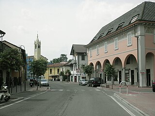
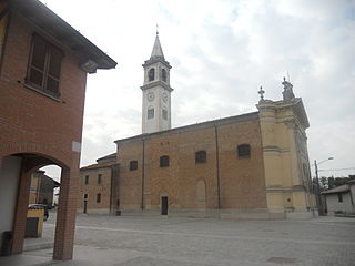
Ripalta Arpina (Cremasco: Riultèla), 1038 inhabitants as of 31 December 2013, [1] is a comune (municipality) in the Province of Cremona in the Italian region of Lombardy. It is located about 50 kilometres (31 mi) southeast of Milan and about 30 kilometres (19 mi) northwest of Cremona.

<i>Comune</i> third-level administrative divisions of the Italian Republic

The comune is a basic administrative division in Italy, roughly equivalent to a township or municipality.

Province of Cremona Province of Italy

The Province of Cremona is a province in the Lombardy region of Italy. Its capital city is Cremona.

Italy republic in Southern Europe

Italy, officially the Italian Republic, is a country in Europe. Located in the middle of the Mediterranean Sea, Italy shares open land borders with France, Switzerland, Austria, Slovenia and the enclaved microstates San Marino and Vatican City. Italy covers an area of 301,340 km2 (116,350 sq mi) and has a largely temperate seasonal and Mediterranean climate. With around 61 million inhabitants, it is the fourth-most populous EU member state and the most populous country in Southern Europe.

Ripalta Arpina borders the following municipalities: Bertonico, Castelleone, Gombito, Madignano, Montodine, Ripalta Cremasca, Ripalta Guerina.

Bertonico Comune in Lombardy, Italy

Bertonico is a comune (municipality) in the Province of Lodi in the Italian region Lombardy, located about 45 kilometres (28 mi) southeast of Milan and about 15 kilometres (9 mi) southeast of Lodi.

Castelleone Comune in Lombardy, Italy

Castelleone is a comune (municipality) in the Province of Cremona in the Italian region of Lombardy, located about 50 kilometres (31 mi) southeast of Milan and about 30 kilometres (19 mi) northwest of Cremona.

Gombito Comune in Lombardy, Italy

Gombito is a comune (municipality) in the Province of Cremona in the Italian region Lombardy, located about 50 kilometres (31 mi) southeast of Milan and about 30 kilometres (19 mi) northwest of Cremona.

Related Research Articles

Capergnanica Comune in Lombardy, Italy

Capergnanica is a comune (municipality) in the Province of Cremona in the Italian region Lombardy, located about 45 kilometres (28 mi) southeast of Milan, about 45 kilometres (28 mi) south of Bergamo and about 40 kilometres (25 mi) northwest of Cremona.

Cicognolo Comune in Lombardy, Italy

Cicognolo is a comune (municipality) in the Province of Cremona in the Italian region Lombardy, located about 90 kilometres (56 mi) southeast of Milan and about 14 kilometres (9 mi) northeast of Cremona. As of 31 December 2012, it had a population of 961 and an area of 7.0 square kilometres (2.7 sq mi).

Credera Rubbiano Comune in Lombardy, Italy

Credera Rubbiano is a comune (municipality) in the Province of Cremona in the Italian region Lombardy, located about 45 kilometres (28 mi) southeast of Milan and about 35 kilometres (22 mi) northwest of Cremona. It was created in 1928 through the merger of the former communes of Credera and Rubbiano.

Formigara Comune in Lombardy, Italy

Formigara is a comune (municipality) in the Province of Cremona in the Italian region Lombardy, located about 50 kilometres (31 mi) southeast of Milan and about 25 kilometres (16 mi) northwest of Cremona.

Madignano Comune in Lombardy, Italy

Madignano is a comune (municipality) in the Province of Cremona in the Italian region Lombardy, located about 45 kilometres (28 mi) southeast of Milan and about 35 kilometres (22 mi) northwest of Cremona. As of 31 December 2006, it had a population of 2,977 and an area of 10.8 square kilometres (4.2 sq mi).

Montodine Comune in Lombardy, Italy

Montodine is a comune (municipality) in the Province of Cremona in the Italian region Lombardy, located about 50 kilometres (31 mi) southeast of Milan and about 30 kilometres (19 mi) northwest of Cremona.

Moscazzano Comune in Lombardy, Italy

Moscazzano is a comune (municipality) in the Province of Cremona in the Italian region Lombardy, located about 45 kilometres (28 mi) southeast of Milan and about 30 kilometres (19 mi) northwest of Cremona.

Pescarolo ed Uniti Comune in Lombardy, Italy

Pescarolo ed Uniti is a comune (municipality) in the Province of Cremona in the Italian region Lombardy, located about 90 kilometres (56 mi) southeast of Milan and about 14 kilometres (9 mi) northeast of Cremona. As of 31 December 2004, it had a population of 1,520 and an area of 16.6 square kilometres (6.4 sq mi).

Pianengo Comune in Lombardy, Italy

Pianengo is a comune (municipality) in the Province of Cremona in the Italian region Lombardy, located about 40 kilometres (25 mi) east of Milan and about 40 kilometres (25 mi) northwest of Cremona. As of 31 December 2004, it had a population of 2,474 and an area of 5.9 square kilometres (2.3 sq mi).

Ripalta Cremasca Comune in Lombardy, Italy

Ripalta Cremasca is a comune (municipality) in the Province of Cremona in the Italian region Lombardy, located about 45 kilometres (28 mi) southeast of Milan and about 35 kilometres (22 mi) northwest of Cremona.

Ripalta Guerina Comune in Lombardy, Italy

Ripalta Guerina is a comune (municipality) in the Province of Cremona in the Italian region Lombardy, located about 45 kilometres (28 mi) southeast of Milan and about 30 kilometres (19 mi) northwest of Cremona.

Solarolo Rainerio Comune in Lombardy, Italy

Solarolo Rainerio is a comune (municipality) in the Province of Cremona in the Italian region Lombardy, located about 100 kilometres (62 mi) southeast of Milan and about 25 kilometres (16 mi) east of Cremona. As of 31 December 2004, it had a population of 1,016 and an area of 11.4 square kilometres (4.4 sq mi).

Spino dAdda Comune in Lombardy, Italy

Spino d'Adda is a comune (municipality) in the Province of Cremona in the Italian region Lombardy, located about 25 kilometres (16 mi) southeast of Milan and about 50 kilometres (31 mi) northwest of Cremona.

Ticengo Comune in Lombardy, Italy

Ticengo is a comune (municipality) in the Province of Cremona in the Italian region Lombardy, located about 50 kilometres (31 mi) east of Milan and about 30 kilometres (19 mi) northwest of Cremona.

Tornata Comune in Lombardy, Italy

Tornata is a comune (municipality) in the Province of Cremona in the Italian region Lombardy, located about 110 kilometres (68 mi) southeast of Milan and about 30 kilometres (19 mi) east of Cremona. As of 31 December 2004, it had a population of 522 and an area of 10.3 square kilometres (4.0 sq mi).

Trigolo Comune in Lombardy, Italy

Trigolo is a comune (municipality) in the Province of Cremona in the Italian region Lombardy, located about 50 kilometres (31 mi) southeast of Milan and about 30 kilometres (19 mi) northwest of Cremona.

Vailate Comune in Lombardy, Italy

Vailate is a comune (municipality) in the Province of Cremona in the Italian region Lombardy, located about 35 kilometres (22 mi) east of Milan and about 50 kilometres (31 mi) northwest of Cremona. As of 31 December 2004, it had a population of 4,299 and an area of 9.8 square kilometres (3.8 sq mi).

References