Megathrust earthquakes occur at convergent plate boundaries, where one tectonic plate is forced underneath another. The earthquakes are caused by slip along the thrust fault that forms the contact between the two plates. These interplate earthquakes are the planet's most powerful, with moment magnitudes (Mw) that can exceed 9.0. Since 1900, all earthquakes of magnitude 9.0 or greater have been megathrust earthquakes.

Many major earthquakes have occurred in the region of the Kamchatka Peninsula in far eastern Russia. Events in 1737, 1923 and 1952, were megathrust earthquakes and caused tsunamis. There are many more earthquakes and tsunamis originating from the region.
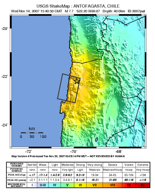
The 2007 Tocopilla earthquake occurred on November 14 at . Its epicenter was located between Quillagua and Tocopilla, affecting the Tarapacá and the Antofagasta regions in northern Chile. The earthquake had a moment magnitude of 7.7 and lasted about 3 minutes and 35 seconds. Seventeen aftershocks of magnitude greater than 5.3, including one of magnitude 7.1 and two others of magnitude 6.3 or higher, were recorded. The Pacific Tsunami Warning Center issued a tsunami warning, stating a tsunami had been generated; after one hour, this warning was cancelled. The earthquake was felt from Santiago, 1,245 km south from the epicenter, to La Paz, about 700 km north-northeast.
The 2005 Tarapacá earthquake occurred on June 13 at 22:44:33 UTC. Its epicenter was located near Mamiña, in northern Chile about 125 km east-northeast of Iquique, affecting the Tarapacá Region and adjacent parts of Bolivia. It had a magnitude of 7.8 and a maximum felt intensity of VII on the Mercalli intensity scale.

Punitaqui is a town and commune of Chile in the Limarí Province.
The 1730 Valparaíso earthquake occurred at 04:45 local time on July 8. It had an estimated magnitude of 9.1–9.3 and triggered a major tsunami with an estimated magnitude of Mt 8.75, that inundated the lower parts of Valparaíso. The earthquake caused severe damage from La Serena to Chillan, while the tsunami affected more than 1,000 km (620 mi) of Chile's coastline.
The 1985 Rapel Lake earthquake occurred on 8 April at with a moment magnitude of 7.2 and a maximum perceived intensity of VI (Strong). The shock was centered 75 kilometres (47 mi) southwest of Santiago, Chile, with a focal depth of 37.8 km (23 mi).

The 1906 Valparaíso earthquake hit Valparaíso, Chile, on August 16 at 19:55 local time. Its epicenter was offshore from the Valparaíso Region, and its magnitude was estimated at 8.2 . This earthquake occurred thirty minutes after the 1906 Aleutian Islands earthquake.

The 2010 Pichilemu earthquakes, also known as the Libertador O'Higgins earthquakes, were a pair of intraplate earthquakes measuring 6.9 and 7.0 that struck Chile's O'Higgins Region on 11 March 2010 about 16 minutes apart. The earthquakes were centred 15 kilometres (9.3 mi) northwest of the city of Pichilemu.

The 2015 Illapel earthquake occurred 46 km (29 mi) offshore from Illapel on September 16 at 19:54:32 Chile Standard Time (22:54:32 UTC), with a moment magnitude of 8.3–8.4. The initial quake lasted between three and five minutes; it was followed by several aftershocks greater than magnitude six and two that exceeded 7.0 moment magnitude. The Chilean government reported 15 deaths, 6 missing and thousands of people affected. In Buenos Aires, Argentina, a man died from a stroke while he was evacuating a building.

The Valparaíso earthquake of April 2017 was a strong earthquake that shook the cities of Valparaíso and Santiago on Monday, April 24, 2017, at 18:38 local time. Its epicenter was located off the coast of the Valparaíso Region and had a magnitude of 6.9 Mw. On the scale of Mercalli, the earthquake reached an intensity of VII.
An earthquake measuring 8.0 struck Peru and the surrounding areas on 26 May 2019 at 02:41 local time. It had a maximum perceived intensity of VII on the Modified Mercalli intensity scale in the towns of Yurimaguas and Lagunas. Two people died and a further 30 were injured. It was the strongest earthquake in 2019 by magnitude.
The Coquimbo Region of Chile was affected by a major earthquake on 6 April 1943 at 12:07 local time. It had a magnitude of between 7.9 and 8.2 on the moment magnitude scale. It triggered a minor tsunami that caused local damage along the coast. A total of 11 people were killed, including a group of five miners.
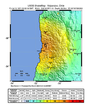
The Valparaíso Region of central Chile was struck by an earthquake of magnitude 7.8 at 22:03 8 July 1971 local time. It had a maximum felt intensity of IX (violent) on the Modified Mercalli intensity scale and caused the deaths of 83 people and injured a further 447.
The 1965 Valparaíso earthquake struck near La Ligua in Valparaíso Region, Chile, about 140 km (87 mi) from the capital Santiago on Sunday, March 28 at 12:33 local time. The moment magnitude (Mw ) 7.4–7.6 earthquake killed 400–500 people and inflicted US$1 billion in damage. Many deaths were from El Cobre, a mining location that was wiped out after a series of dam failures caused by the earthquake spilled mineral waste onto the area, burying hundreds of residents. The shock was felt throughout the country and along the Atlantic coast of Argentina.

The 2019 Coquimbo earthquake occurred 10 km south southwest of Coquimbo in Chile, on January 19, 2019 at 22:32. The epicenter was located off the coast of the Coquimbo Region at a depth of 63.0 km,) and had a moment magnitude of 6.7. On the Mercalli scale, the earthquake reached an intensity of VIII.

An earthquake occurred off the coast of the Alaska Peninsula on July 28, 2021, at 10:15 p.m. local time. The large megathrust earthquake had a moment magnitude of 8.2 according to the United States Geological Survey (USGS). A tsunami warning was issued by the National Oceanic and Atmospheric Administration (NOAA) but later cancelled. The mainshock was followed by a number of aftershocks, including three that were of magnitude 5.9, 6.1 and 6.9 respectively.
The 1950 Calama earthquake occurred near the Argentina–Chile border with an epicenter near Calama, Chile in the Atacama Desert on December 9. The event had a hypocenter depth of 113.9 km, beneath the Caichinque volcanic complex. It measured magnitude Mw 8.2 on the moment magnitude scale, making it the largest intermediate depth earthquake ever recorded on Chilean soil. One person was killed and an unspecified number of people were injured in Calama.
The 1657 Concepción earthquake occurred on March 15 at 20:00 local time off the coast of Concepción, Biobío Region in the Spanish Empire. The earthquake caused severe damage along the coast, and generated a large tsunami in the Bay of Concepción. At least 40 people were killed, the majority due to drowning from the tsunami. The town of Concepción was the hardest hit, with the earthquake and tsunami totally destroying it.
The 2012 Constitución earthquake was recorded on March 25, 2012, at 7:37 pm local time. It had a moment magnitude of 7.1 and its epicenter was located 23 km (14 mi) northeast of the city of Constitución, in the Maule Region, Chile. According to experts, it was a strong and late aftershock of the Great Chile earthquake of February 27, 2010.


