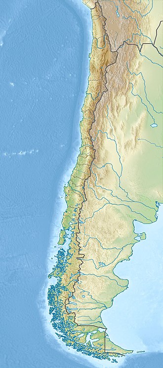
UTC time | 1928-12-01 04:06:17 |
---|---|
ISC event | 908986 |
USGS-ANSS | ComCat |
Local date | 1 December 1928 [1] |
Local time | 00:06 |
Duration | 1 minute 45 seconds [2] |
Magnitude | 7.6 Mw, [3] 8.3 MS, [1] 7.9 ML [4] |
Depth | 20 km (centroid) [5] |
Epicenter | 35°00′S72°00′W / 35.000°S 72.000°W [1] [4] |
Areas affected | Chile, Curepto |
Max. intensity | MMI IX (Violent) [2] |
Aftershocks | 7.0 Mw (USGS) 1928-12-02 |
Casualties | 279 dead [2] |
The 1928 Talca earthquake occurred on 1 December at 00:06 local time near Curepto, Maule Region, Chile, [1] [4] with an estimated magnitude of 7.6 MW, [3] 8.3 MS [1] and 7.9 ML. [4] In Talca, it lasted 1 minute 45 seconds. [2]
There was damage between Valparaíso and Concepción, [2] and severe damage on the coast from Cauquenes to Pichilemu, and in the following cities in the Chilean Central Valley: Talca, Curicó and San Fernando. [5]
In Talca there were 108 dead, 67 in Constitución, and 50 in the surrounding villages. [4] Soon after the earthquake, the Barahona dam, in the valley of Cachapoal River, that contained copper tailings, collapsed, killing 54 miners. [2]
In total, there were 279 dead, [2] 1,083 wounded and 127,043 homeless.
The 1960 Valdivia earthquake and tsunami or the Great Chilean earthquake on 22 May 1960 was the most powerful earthquake ever recorded. Most studies have placed it at 9.4–9.6 on the moment magnitude scale, while some studies have placed the magnitude lower than 9.4. It occurred in the afternoon, and lasted 10 minutes. The resulting tsunamis affected southern Chile, Hawaii, Japan, the Philippines, eastern New Zealand, southeast Australia, and the Aleutian Islands.
The Maule Region is one of Chile's 16 first order administrative divisions. Its capital is Talca. The region derives its name from the Maule River which, running westward from the Andes, bisects the region and spans a basin of about 20,600 km2. The Maule river is of considerable historic interest because, among other reasons, it marked the southern limits of the Inca Empire.
Talca is a city and commune in Chile located about 255 km (158 mi) south of Santiago, and is the capital of both Talca Province and Maule Region. As of the 2012 census, the city had a population of 201,142.
The 1977 San Juan earthquake, also known as Caucete earthquake, took place in the province of San Juan, Argentina, on 23 November at 06:26:26 AM. It measured 7.5 on the moment magnitude scale, and had a maximum perceived intensity of X (Extreme) on the Mercalli intensity scale.
The 1922 Vallenar earthquake occurred with a moment magnitude of 8.5–8.6 and a tsunami magnitude of 8.7 in the Atacama Region of Chile, near the border with Argentina on 11 November at 04:32 UTC. It triggered a destructive tsunami that caused significant damage to the coast of Chile and was observed as far away as Australia.
The 2010 Chile earthquake occurred off the coast of central Chile on Saturday, 27 February at 03:34:12 local time, having a magnitude of 8.8 on the moment magnitude scale, with intense shaking lasting for about three minutes. It was felt strongly in six Chilean regions that together make up about 80 percent of the country's population. According to the United States Geological Survey (USGS) the cities experiencing the strongest shaking—VIII (Severe) on the Mercalli intensity scale (MM)—were Concepción, Arauco, and Coronel. According to Chile's Seismological Service, Concepción experienced the strongest shaking at MM IX (Violent). The earthquake was felt in the capital Santiago at MM VII or MM VIII. Tremors were felt in many Argentine cities, including Buenos Aires, Córdoba, Mendoza, and La Rioja. Tremors were felt as far north as the city of Ica in southern Peru. It is the largest earthquake to hit Chile since the 1960 Valdivia earthquake.
The 1687 Peru earthquake occurred at 11:30 UTC on 20 October 1687. It had an estimated magnitude of 8.4–8.7 and caused severe damage to Lima, Callao and Ica. It triggered a tsunami and overall, about 5,000 people died.
The 1985 Rapel Lake earthquake occurred on 8 April at 21:56:59 local time with a moment magnitude of 7.2 and a maximum perceived intensity of VI (Strong). The shock was centered 75 kilometres (47 mi) southwest of Santiago, Chile, with a focal depth of 37.8 km (23 mi).
The 1906 Valparaíso earthquake hit Valparaíso, Chile, on August 16 at 19:55 local time. Its epicenter was offshore from the Valparaíso Region, and its magnitude was estimated at 8.2 Mw. This earthquake occurred thirty minutes after the 1906 Aleutian Islands earthquake.
The 2010 Pichilemu earthquakes, also known as the Libertador O'Higgins earthquakes, were a pair of intraplate earthquakes measuring 6.9 and 7.0 Mw that struck Chile's O'Higgins Region on 11 March 2010 about 16 minutes apart. The earthquakes were centred 15 kilometres (9.3 mi) northwest of the city of Pichilemu.
The 1994 offshore Sanriku earthquake occurred on December 28, 1994, at 12:19 UTC. This was a magnitude Mw 7.7 earthquake with epicenter located in the Pacific Ocean at about 180 km east of Hachinohe, Aomori. The intensity reached shindo 6 in Hachinohe, Aomori, about 187.6 km from epicenter. It could be felt in Tokyo, about 632.9 km from epicenter, with shindo 2. The Japanese Meteorological Agency put the magnitude at MJMA 7.5. Slip associated with this earthquake continued for more than a year and it has been termed an 'ultra-slow earthquake'.
The 1937 Orizaba earthquake occurred on July 26 at 03:47 UTC, near Orizaba, Veracruz, Mexico. It had a magnitude of 7.3 on the surface-wave magnitude scale. Thirty four people were reported dead. Damage was reported in Esperanza, Puebla. This was an intraplate earthquake within the subducting Cocos plate.
The 2003 Puerto Armuelles earthquake occurred on December 25 at 02:11 local time. The epicenter was located in Panama, at about 7 km east of Puerto Armuelles, near the Panama-Costa Rica border. The earthquake had a magnitude of Mw 6.5. Two people were reported dead in Puerto Armuelles. There was building damage in Panama and Costa Rica. Power outage lasted for about four hours in Puerto Armuelles. The maximal intensity was MM VIII in Finca Naranjo, Costa Rica. The intensity was MM VII in Armuelles, Panama, and MM IV in Limón and the Central Valley, Costa Rica, including San José. This earthquake could also be felt in Panama City.
The 1928 Chachapoyas earthquake occurred on May 14 at 17:14 local time. It had a magnitude of Mw 7.2, Ms 7.3, or ML 7.3. Chachapoyas, Peru was almost completely destroyed. A landslide in Pinpincos caused the death of 25 people. Many houses were damaged in Machala, Ecuador. The maximum intensity was X (Extreme) on the Mercalli intensity scale. The earthquake could be felt in Lima. It could also be felt in Ecuador, Brazil, and Colombia.
The 1964 Guerrero earthquake occurred on July 6 at 01:22 local time in Guerrero, Mexico. The magnitude of this earthquake was given as Ms 7.4, or ML 7.2.
The 1942 Guatemala earthquake occurred at 17:37 local time on August 6 and had ratings of 7.7 on the moment magnitude scale and 7.9 on the surface-wave magnitude scale. The epicenter was located off the southern coast of Guatemala, and it was one of the strongest earthquakes ever recorded there.
The Ramal Talca-Constitución, also known as the Ramal de Maule is the last remaining narrow-gauge ramal in Chile. Its 88-kilometre (55 mi) route follows the north bank of the Maule River and crosses the communes of Talca, Maule, Pencahue and Constitución, with Constitución the last station on the line. The route features views of the Andean foothills and the Pacific Ocean. The line can support a speed of 50 miles per hour (80 km/h). The railway is facing closure due to inactivity and an increased preference for private transport.
The 1940 Lima earthquake occurred on May 24 at 11:35 a.m. PST with a magnitude of Mw 8.2 on the moment magnitude scale. Shaking from this powerful earthquake was felt throughout the country, and in Ecuador and Chile. An estimated 179 to 300 people died while 3,500 left injured by the earthquake. The earthquake was centered near the coastal cities of Huacho and Huaura, about 150 km (93 mi) north of the Peruvian capital, Lima. There was a tsunami of up to 2 m that did not cause damage.
The 1993 Kushiro–Oki earthquake was one of two large earthquake to strike the Japanese island of Hōkkaido within the same year. The earthquake with a magnitude of 7.6 Mw or 7.8 MJMA struck at 11:06 UTC or 08:06 pm JST on January 15 near the town of Ashoro. Shaking reached a maximum intensity of IX (Violent) on the Mercalli intensity scale, causing considerable damage, and was felt throughout the island, into northern Honshu, Sakhalin, and the Kuril Islands. As a result of the tremors, two people were killed and more than 600 were wounded.