 | |
| UTC time | 1920-02-20 11:44:40 |
|---|---|
| ISC event | 912437 |
| USGS-ANSS | ComCat |
| Local date | February 20, 1920 |
| Local time | 15:44:40 [1] |
| Magnitude | 6.2 Ms [2] |
| Depth | 11 km (6.8 mi) [1] |
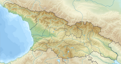
| Epicenter | 42°00′N44°06′E / 42.0°N 44.1°E [1] |
| Areas affected | Georgia |
| Max. intensity | MMI IX (Violent) [1] |
| Casualties | 114–130 [1] [2] |
The 1920 Gori earthquake hit the Democratic Republic of Georgia on 20 February at 15:44 local time. The shock had a surface-wave magnitude of 6.2 and a maximum Mercalli Intensity of IX (Violent). Heavy damage (and between 114 and 130 deaths) affected the town of Gori and its medieval fortress.