Incahuasi District

Last updated
Incahuasi

Inkawasi
Iglesia de Inachuasi durante la procesion de la festividad del Nino Dios de Reyes 2011.jpg
Church of Incahuasi during a procession
Country Flag of Peru.svg  Peru
Region Lambayeque
Province Ferreñafe
FoundedFebruary 17, 1951
Capital Incahuasi
Government
   Mayor William Hidalgo Manayay Manayay
(2019-2022)
Area
  Total443.91 km2 (171.39 sq mi)
Elevation
3,078 m (10,098 ft)
Population
(2017)
  Total13,858
  Density31/km2 (81/sq mi)
Time zone UTC-5 (PET)
UBIGEO 140203

Incahuasi District or Inkawasi [1] (Quechua Inka Inca, wasi house, "Inca house") [2] [3] is one of six districts of the Ferreñafe Province in the Department of Lambayeque in Peru. [4]

Inca Empire empire in pre-Columbian America

The Inca Empire, also known as the Incan Empire and the Inka Empire, was the largest empire in pre-Columbian America. Its political and administrative structure is considered by most scholars to have been the most developed in the Americas before Columbus' arrival. The administrative, political and military center of the empire was located in the city of Cusco. The Inca civilization arose from the Peruvian highlands sometime in the early 13th century. Its last stronghold was conquered by the Spanish in 1572.

Districts of Peru third level administrative subdivision of Peru

The districts of Peru are the third-level country subdivisions of Peru. They are subdivisions of the provinces, which in turn are subdivisions of the larger regions or departments. There are 1,838 districts in total.

Ferreñafe Province Province in Lambayeque, Peru

The Ferreñafe Province is the smallest of three provinces of the Lambayeque Region in Peru.

Ethnic groups

The people in the district are mainly indigenous citizens of Quechua descent. Quechua (Inkawasi-Kañaris Quechua) is the language which the majority of the population (85.72%) learnt to speak in childhood, 14.08% of the residents started speaking using the Spanish language (2007 Peru Census). [5]

Indigenous peoples of the Americas Pre-Columbian inhabitants of North, Central, and South America and their descendants

The indigenous peoples of the Americas are the Pre-Columbian peoples of North, Central and South America and their descendants.

Quechua people ethnic group

Quechua people or Quecha peoples, may refer to any or all speakers of the Quechua languages, which originated among the indigenous peoples of South America. Most Quechua speakers are native to Peru, although there are some significant populations living in Ecuador, Bolivia, Chile, Colombia and Argentina.

Spanish language Romance language

Spanish or Castilian is a Romance language that originated in the Castile region of Spain and today has hundreds of millions of native speakers in the Americas and Spain. It is a global language and the world's second-most spoken native language, after Mandarin Chinese.

Related Research Articles

Pomabamba District District in Ancash, Peru

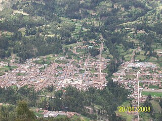
Pomabamba is the largest of 4 districts in the Pomabamba Province of the Ancash Region in Peru.

Chilcayoc District District in Ayacucho, Peru

Chilcayoc or Ch'illkayuq is the smallest of 11 districts of the Sucre Province in the Ayacucho region in Peru.

The Ccatca District is one of the twelve districts in the Quispicanchi Province in Peru. Its capital is the town of Ccatca.

The Cusipata District is one of the twelve districts in the Quispicanchi Province in Peru. Created by Law No. 9164 on September 5, 1940, its capital is the town of Cusipata.

The Marcapata District is one of the twelve districts in the Quispicanchi Province in Peru. Created on January 20, 1869, its capital is Marcapata.

Urcos District District in Cusco, Peru

The Urcos District is one of the twelve districts in the Quispicanchi Province in Peru. Created on January 2, 1857, its capital is the town of Urcos. The closest airport is the TBP Airport which is located about 13.4 km north-east of Urcos. Urcos is southeast of the former Inca capital, Cusco, in the southern Andes, and it is at an altitude of 3,180 meters.

Ranracancha is one of the eight districts of the province Chincheros in Peru.

Cañaris District is one of six districts of the province Ferreñafe in Peru.

San Pedro District is one of eight districts of the province Canchis in Peru.

Quelloúno is one of ten districts of the La Convención Province in the Cusco Region in Peru.

Accha District is one of nine districts of the province Paruro in Peru.

Omacha District is one of nine districts of the province Paruro in Peru.

Caicay District is one of six districts of the province Paucartambo in Peru.

Maras District District in Cusco, Peru

Maras District is one of seven districts of the Urubamba Province in Peru.

Singa District District in Huánuco, Peru

Singa or Sinqa is one of eleven districts of the province Huamalíes in Peru.

Chinchihuasi District District in Huancavelica, Peru

Chinchihuasi or Chinchi Wasi is one of ten districts of the Churcampa Province in Peru.

Isla Incahuasi, Inkawasi or Inka Wasi is a hilly and rocky outcrop of land and former island in Bolivia situated in the middle of Salar de Uyuni, the world's largest salt flat, at an elevation of 3,656 meters. It is located in the Potosí Department, Daniel Campos Province, Tahua Municipality, Yonza Canton. Isla Incahuasi is the Spanish name where isla means island, Inca stands for Inca, and huasi is derived from the Quechua word wasi meaning house.

Inka Wasi, Ayacucho

Inka Wasi or Inkawasi is an archaeological site in Peru. It is located in the Ayacucho Region, Parinacochas Province, Pullo District.

Inka Wasi, Huancavelica

Inka Wasi is an archaeological site in the Huancavelica Region in Peru. The Inca palace is considered one of the most important monuments of the Huancavelica Region. Inka Wasi is located in the Huaytará Province, Huaytará District, about 25 km from Huaytará. It is situated at a height of 3,804 m (12,480 ft).

Runkuraqay mountain in Peru

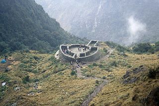
Runkuraqay or Runku Raqay is an archaeological site on a mountain of the same name in Peru located in the Cusco Region, Urubamba Province, Machupicchu District. It is situated southeast of the archaeological site Machu Picchu and south of the Vilcanota river. The ruins lie on the southern slope of the mountain Runkuraqay near the Runkuraqay pass, northeast of the archaeological site Sayacmarca and southeast of the site Qunchamarka.

References

  1. muniferrenafe.gob.pe
  2. Teofilo Laime Ajacopa, Diccionario Bilingüe Iskay simipi yuyayk'ancha, La Paz, 2007 (Quechua-Spanish dictionary)
  3. Diccionario Quechua - Español - Quechua, Academía Mayor de la Lengua Quechua, Gobierno Regional Cusco, Cusco 2005 (Quechua-Spanish dictionary)
  4. (in Spanish) Instituto Nacional de Estadística e Informática. Banco de Información Distrital Archived 2008-04-23 at the Wayback Machine . Retrieved April 11, 2008.
  5. inei.gob.pe Archived 2013-01-27 at the Wayback Machine INEI, Peru, Censos Nacionales 2007, Frequencias: Preguntas de Población: Idioma o lengua con el que aprendió hablar (in Spanish)

Coordinates: 6°14′09″S79°19′00″W / 6.2357°S 79.3168°W / -6.2357; -79.3168

Geographic coordinate system Coordinate system

A geographic coordinate system is a coordinate system that enables every location on Earth to be specified by a set of numbers, letters or symbols. The coordinates are often chosen such that one of the numbers represents a vertical position and two or three of the numbers represent a horizontal position; alternatively, a geographic position may be expressed in a combined three-dimensional Cartesian vector. A common choice of coordinates is latitude, longitude and elevation. To specify a location on a plane requires a map projection.