Pimentel District

Last updated
Pimentel
Jose quinones plaza pimentel.jpg
Monument in memory of José Quiñones Gonzales
Country Flag of Peru.svg  Peru
Region Lambayeque
Province Chiclayo
FoundedOctober 18, 1920
Capital Pimentel
Government
   Mayor Cesar Roberto Jacinto Purizaca
Area
  Total66.53 km2 (25.69 sq mi)
Elevation
4 m (13 ft)
Population
  Total44,602
  Density670/km2 (1,700/sq mi)
Time zone UTC-5 (PET)
UBIGEO 140112

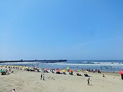
Pimentel District is one of twenty districts of the Chiclayo province in Peru. The beach (Playa Pimentel) and reed watercraft caballitos de totora are among its most popular attractions. [1]

Districts of Peru third level administrative subdivision of Peru

The districts of Peru are the third-level country subdivisions of Peru. They are subdivisions of the provinces, which in turn are subdivisions of the larger regions or departments. There are 1,838 districts in total.

Chiclayo Province Province in Lambayeque, Peru

The Chiclayo Province is one of three provinces of the Lambayeque Region in Peru.

Peru Republic in South America

Peru, officially the Republic of Peru, is a country in western South America. It is bordered in the north by Ecuador and Colombia, in the east by Brazil, in the southeast by Bolivia, in the south by Chile, and in the west by the Pacific Ocean. Peru is a megadiverse country with habitats ranging from the arid plains of the Pacific coastal region in the west to the peaks of the Andes mountains vertically extending from the north to the southeast of the country to the tropical Amazon Basin rainforest in the east with the Amazon river.

Contents

Surf school pimentel.jpg

Related Research Articles

Sexi District is one of eleven districts of the province Santa Cruz in northern Peru. Chiclayo is the nearest metropolitan center to the east of Sexi, from which one may travel by car or bus to the district.

Cayalti District is one of twenty districts of the province Chiclayo in Peru.

Chiclayo District is one of twenty districts of the Chiclayo province in Peru. The district is home to the principal city of Chiclayo.

Etén District District in Lambayeque, Peru

Etén District is one of twenty districts of the province Chiclayo in Peru.

Etén Puerto District is one of twenty districts of the province Chiclayo in Peru.

José Leonardo Ortiz District is one of twenty districts of the province Chiclayo in Peru.

La Victoria District is one of twenty districts of the province Chiclayo in Peru.

Lagunas District is one of twenty districts of the province Chiclayo in Peru.

Monsefú District is one of twenty districts of the province Chiclayo in Peru.

Nueva Arica District is one of twenty districts of the province Chiclayo in Peru.

Oyotún District is one of twenty districts of the province Chiclayo in Peru.

Picsi District is one of twenty districts of the province Chiclayo in Peru.

Pomalca District is one of twenty districts of the province Chiclayo in Peru.

Pucalá District is one of twenty districts of the province Chiclayo in Peru.

Reque District is one of twenty districts of the province Chiclayo in Peru.

Saña District District in Lambayeque, Peru

Saña District is one of twenty districts of the province Chiclayo in Peru.

Santa Rosa District is one of twenty districts of the province Chiclayo in Peru.

Tuman District is one of twenty districts of the province Chiclayo in Peru.

References

Coordinates: 6°50′09″S79°56′08″W / 6.8359°S 79.9356°W / -6.8359; -79.9356

Geographic coordinate system Coordinate system

A geographic coordinate system is a coordinate system that enables every location on Earth to be specified by a set of numbers, letters or symbols. The coordinates are often chosen such that one of the numbers represents a vertical position and two or three of the numbers represent a horizontal position; alternatively, a geographic position may be expressed in a combined three-dimensional Cartesian vector. A common choice of coordinates is latitude, longitude and elevation. To specify a location on a plane requires a map projection.