This is a list of earthquakes in 2025. Only earthquakes of magnitude 6 or above are included, unless they result in significant damage and/or casualties. All dates are listed according to UTC time. The maximum intensities are based on the Modified Mercalli intensity scale. Earthquake magnitudes are based on data from the United States Geological Survey (USGS).
The year 2025 was an active and highly deadly year for earthquakes, with 16 major events and around 8,000 fatalities. The Mw 8.8 Kamchatka earthquake was the first ≥M8 earthquake since 2021, and the sixth-largest instrumentally recorded earthquake since records began. The deadliest event of the year was a Mw 7.7–7.9 event in Myanmar, which caused unprecedented destruction in much of the country and killed at least 5,400 people, although the true death toll is believed to be significantly higher. This was followed by a Mw 6.0 event in Afghanistan in August that killed over 2,200 people, almost all of them in Kunar Province. Other notable and deadly earthquakes occurred in China, the Philippines, Bangladesh and Guatemala.
Aftershock of the 6.0 event on January 20. One person injured in Nansi, the walls of several homes and a school collapsed, many others damaged and power outages in the Dongshan area.[66][67][68]
Aftershock of the 6.0 event on January 20. One home destroyed in Nansi; at least 10 others and a school damaged and power outages in the Dongshan area.[70]
Some buildings cracked and power outages in parts of Honduras and Belize.[87] A 3-centimetre-high (1.2in) tsunami observed at Isla Mujeres, Mexico.[88]
Six people injured in the Sindhupalchowk-Dhading-Kathmandu area;[97] two homes destroyed and five others damaged in Sankhuwasabha;[98] one home destroyed, three others, a barn and a police station damaged in Sindhupalchowk District.[97]
One person killed,[133] another person injured, two structures destroyed and two others buried by a landslide, 18 structures damaged and landslides blocked roads in North Tapanuli Regency.[134]
Several walls collapsed, one home destroyed, eight structures including a church damaged, landslides and ground cracks occurred in the El Poblado-Tuxpan area.[185][186][187]
One person injured in Yamagata.[189] A stonework collapsed, 10 homes and a temple damaged in Ōmachi.[190] About 100 homes lost power in the Ogawa-Nagano area.[189]
Forty-nine people injured, 254 homes collapsed, 1,150 others,[197][198][199] 88 buildings, two bridges and 60 roads damaged, landslides and power outages affected 80% of households in Esmeraldas.[200][201]
Some people hospitalized,[210] many homes collapsed, numerous churches damaged, landslides, ground cracks and power outages in Famatina.[211][212][213]
Some walls collapsed, 54 structures and some roads damaged, power, telephone, and internet outages occurred in the Caravelí-Lucanas area.[242][243][244]
One person killed in Fethiye.[285] Seventy-five others injured, some buildings and a mosque collapsed and numerous homes damaged in the Muğla area.[286][287] Minor damage to buildings in Rhodes, Greece.[288]
Two people injured, one home destroyed, 246 structures and some roads damaged, four water mains ruptured, power outages occurred and landslides in the Chañaral-Copiapó-Diego de Almagro-Tierra Amarilla-Vallenar area.[296][297][298][299]
Two people killed and another person injured after a tree fell due to the shaking and struck two vehicles in Meerut.[333] One wall collapsed and one school damaged in the Jhajjar area.[334]
Some roads damaged in Southwest Maluku Regency.[338] Several gardens and a road damaged, landslides occurred, and sand dunes as well as coral and gravel formations appeared along the coastline in the Tual area.[339]
Foreshock of the 2025 Kamchatka earthquake. Minor damage to some hospitals and clinics in the Petropavlovsk-Kamchatsky area.[353] A tsunami with a maximum run-up of 1.53m (5ft 0in) was recorded at the mouth of the Khalaktyrka River.[354]
Two people killed, 26 others injured, at least 1,386 homes, five public buildings, eight schools and a church damaged or destroyed and power outages occurred in the Comapa-Jutiapa area.[376][377][378][379] One person injured, 66 homes destroyed, 375 others, two churches and a school damaged in the Ahuachapan-Chalchuapa area, El Salvador.[380][381][382]
Aftershock of the 2025 Kunar earthquake. Many people injured, several previously damaged homes destroyed and rockslides occurred in the epicentral area.[435]
One person died while trying to repair their damaged roof, another injured, two homes destroyed and 233 structures damaged in the Frontino-Uramita area.[449][450][451]
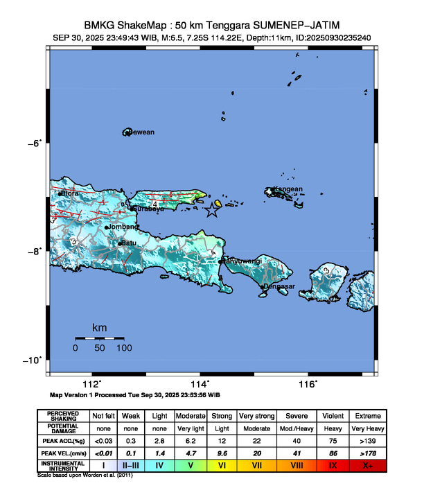
Three people injured, two homes, one bridge and a church collapsed, 15 structures including the Douw Aturure Airport and another bridge damaged and power and telecommunication outages in Nabire Regency.[457][458][459][460]
Aftershock of the 2025 Kamchatka earthquake. At least four buildings and a swimming pool damaged in the Petropavlovsk-Kamchatsky area.[462] Tsunami waves measuring up to 62cm (2.03ft) recorded near the Maly Semyachik volcano and 6cm (0.2ft) in the western Aleutian Islands region.[463][464]
One person killed, nine others injured, at least five homes destroyed, 1,452 structures and 74 water wells damaged, and more than 43,400 people displaced in the Berhale-Dallol-Koneba-Mekelle area.[521][522][523]
One wall collapsed in Kelokedara, several homes and buildings including a monastery damaged, rockfalls and telecommunication outages occurred in Paphos District.[577][578]
Twelve people injured, several buildings and the roof of an office building collapsed, one mosque and a health center damaged and a warehouse caught fire in Simeulue Regency.[592][593]
↑Noviansah, Wildan (20 August 2025). "Musala di Bekasi Roboh Usai Diguncang Gempa M 4,9"[A prayer room in Bekasi collapsed after being struck by a 4.9 magnitude earthquake.]. Detik.com (in Indonesian). Retrieved 20 August 2025.
This page is based on this Wikipedia article Text is available under the CC BY-SA 4.0 license; additional terms may apply. Images, videos and audio are available under their respective licenses.


