Lobuche, Nepal

Last updated
Lobuche
लोबुचे
Lobuche.nepal.jpg
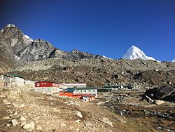
Partial view of Lobuche from the trail lead to Dughla (Thukla)
Nepal adm location map.svg
Red pog.svg
Lobuche
Location in Nepal
Coordinates: 27°56′53″N86°48′37″E / 27.94806°N 86.81028°E / 27.94806; 86.81028
Country Nepal
Zone Sagarmatha
District Solukhumbu
Elevation
4,940 m (16,210 ft)
Time zone UTC+5:45 (Nepal Time)

Lobuche (or Lobuje) is a small settlement near Mount Everest in the Khumbu region of Nepal. It is one of the last overnight stops with lodging on the "trail to base camp", a hike that climbers make on their way to Everest Base Camp (South) when attempting an ascent of Everest via the standard southeast route. It is also a popular stop among trekkers in the area. From there they can complete the trail on to EBC or stop at Gorak Shep, the last stop with lodging on the trail, and climb the modest nearby peak, Kala Patthar (5,545 m, 18,192 ft), for a rare view of the Everest summit. [1] The structure of Everest is such that its actual summit is not visible from Base Camp.

Lobuche, at an elevation of about 4,940 metres (16,210 ft), lies about 150 kilometres (93 mi) east of Nepal's capital Kathmandu. It is located near the foot of the Khumbu Glacier, approximately 8.5 km SW of the Everest Base Camp. [2] [3] [4] It shares its name with several peaks in the area: Lobuche Far East, Lobuche East and Lobuche West (a separate mountain further west). Labuche Kang (sometimes spelled Lobuche Kang) is not local but is in Tibet.

Lobuche is a particularly busy place each year in the month of April as hundreds of porters and Sherpas from the region pass through Lobuche on their way to Base Camp. Many of them also move supplies, with the aid of yaks or other means, for various climbers and expeditions also traveling up the trail in preparation for the Everest spring climbing season in May.

The lodging accommodations at Lobuche are notoriously primitive, [5] consisting mostly of stone huts with shared bunk dormitories. [1] In recent years there have been some additions of more modern facilities and amenities including seven lodges providing 200 twin-bed rooms. Some lodges provide internet and oxygen services.

Map of the Khumbu region KarteKhumbu.jpg
Map of the Khumbu region
Mountain view near Lobuche.jpg
View of Nuptse from near Lobuche

Related Research Articles

<span class="mw-page-title-main">Kangchenjunga</span> Third highest mountain in the world

Kangchenjunga, also spelled Kanchenjunga, Kanchanjanghā and Khangchendzonga, is the third-highest mountain in the world. Its summit lies at 8,586 m (28,169 ft) in a section of the Himalayas, the Kangchenjunga Himal, which is bounded in the west by the Tamur River, in the north by the Lhonak River and Jongsang La, and in the east by the Teesta River. It lies in the border region between Nepal and Sikkim state of India, with three of the five peaks, namely Main, Central and South, directly on the border, and the peaks West and Kangbachen in Nepal's Taplejung District.

<span class="mw-page-title-main">Mount Everest</span> Earths highest mountain

Mount Everest is Earth's highest mountain above sea level, located in the Mahalangur Himal sub-range of the Himalayas. The China–Nepal border runs across its summit point. Its elevation of 8,848.86 m was most recently established in 2020 by the Chinese and Nepali authorities.

<span class="mw-page-title-main">Sherpa people</span> Tibetan ethnic group

The Sherpa are one of the Tibetan ethnic groups native to the most mountainous regions of Nepal, Tingri County in the Tibet Autonomous Region and the Himalayas. The term sherpa or sherwa derives from the Tibetan-language words ཤར shar ('east') and པ pa ('people'), which refer to their geographical origin in eastern Tibet.

<span class="mw-page-title-main">Lhotse</span> Eight-thousander and 4th-highest mountain on Earth, located in Nepal and China

Lhotse is the fourth highest mountain in the world at 8,516 metres (27,940 ft), after Mount Everest, K2, and Kangchenjunga. The main summit is on the border between Tibet Autonomous Region of China and the Khumbu region of Nepal.

<span class="mw-page-title-main">Cho Oyu</span> 6th-highest mountain on Earth, located in Nepal and China

Cho Oyu is the sixth-highest mountain in the world at 8,188 metres (26,864 ft) above sea level. Cho Oyu means "Turquoise Goddess" in Tibetan. The mountain is the westernmost major peak of the Khumbu sub-section of the Mahalangur Himalaya 20 km west of Mount Everest. The mountain stands on the China Tibet–Nepal Province No. 1 border.

<span class="mw-page-title-main">Pumori</span> Mountain in the Himalayan range, located in Nepal and China

Pumori is a mountain on the Nepal-China border in the Mahalangur section of the Himalayas. Pumori lies just eight kilometres west of Mount Everest. Pumori, meaning "the Mountain Daughter" in Sherpa language, was named by George Mallory. "Pumo" means young girl or daughter and "Ri" means mountain in Sherpa language. Climbers sometimes refer to Pumori as "Everest's Daughter". Mallory also called it Clare Peak, after his daughter.

<span class="mw-page-title-main">Anatoli Boukreev</span> Kazakh mountain climber

Anatoli Nikolaevich Boukreev was a Soviet and Kazakh mountaineer who made ascents of 10 of the 14 eight-thousander peaks—those above 8,000 m (26,247 ft)—without supplemental oxygen. From 1989 through 1997, he made 18 successful ascents of peaks above 8000 m.

<span class="mw-page-title-main">Khumbu Icefall</span> Glacier in Nepal

The Khumbu Icefall is located at the head of the Khumbu Glacier and the foot of the Western Cwm, which lies at an elevation of 5,486 metres (17,999 ft) on the Nepali slopes of Mount Everest, not far above Base Camp and southwest of the summit. The icefall is considered one of the most dangerous stages of the South Col route to Everest's summit.

<span class="mw-page-title-main">Gorakshep</span> Place

Gorak Shep, also spelled Gorakshep, is a settlement nestled on the periphery of a frozen lakebed blanketed with sand in Nepal, sharing its name with the locale. Situated at an elevation of 5,164 meters near Mount Everest, it remains uninhabited for most of the year, reopening only for the Mount Everest trekking season.

<span class="mw-page-title-main">Western Cwm</span> Valley at the foot of Mount Everest

The Western Cwm is a broad, flat, gently undulating glacial valley basin terminating at the foot of the Lhotse Face of Mount Everest. It was named by George Mallory when he saw it in 1921 as part of the British Reconnaissance Expedition that was the first to explore the upper sections of Everest, searching for routes for future summit attempts; Cwm is Welsh for "valley".

<span class="mw-page-title-main">Everest base camps</span> Staging areas for mountaineering activities on Mount Everest

There are two base camps on Mount Everest, on opposite sides of the mountains: South Base Camp is in Nepal at an altitude of 5,364 metres (17,598 ft), while North Base Camp is in China at 5,150 metres (16,900 ft).

<span class="mw-page-title-main">1996 Mount Everest disaster</span> Death of eight climbers

The 1996 Mount Everest disaster occurred on 10–11 May 1996 when eight climbers caught in a blizzard died on Mount Everest while attempting to descend from the summit. Over the entire season, 12 people died trying to reach the summit, making it the deadliest season on Mount Everest at the time and the third deadliest after the 22 fatalities resulting from avalanches caused by the April 2015 Nepal earthquake and the 16 fatalities of the 2014 Mount Everest avalanche. The 1996 disaster received widespread publicity and raised questions about the commercialization of Everest.

<span class="mw-page-title-main">Pheriche</span> Village in Province No. 1, Nepal

Pheriche is a village in the Khumbu region of eastern Nepal. Situated at an altitude of about 4,371 m (14,340 ft), above the Tsola River, Pheriche is a popular stop for trekkers and climbers. There is a rudimentary hospital in Pheriche managed by the Himalayan Rescue Association. The Pheriche hospital is open only during the two trekking/climbing seasons. Although the hospital was built with Japanese support in 1975, it is staffed by Nepalis and volunteer physicians who are mostly from the US, Europe, Canada and Australia. Pheriche was primarily a farming village raising potatoes and buckwheat, and keeping yaks. However, now in the summer, many of its men are employed by trekkers as guides and porters. There are also many lodges where trekkers and climbers on their way to the Mt. Everest Base Camp can stay. It is an important acclimatization stopover.

<i>High Ground</i> (2012 film) 2012 American film

High Ground is a 2012 documentary film about eleven veterans who set off to climb the tallest peak in the Himalayas to heal the physical and emotional wounds of war. The expedition is led by blind adventurer Erik Weihenmayer, the first blind man to summit Mount Everest, and a team of experienced mountain climbers who guide this team of wounded veterans up the summit.

<span class="mw-page-title-main">Ang Dorje Sherpa</span> Nepalese sherpa (born 1970)

Ang Dorje (Chhuldim) Sherpa is a Nepalese sherpa mountaineering guide, climber, and porter from Pangboche, Nepal, who has climbed to the summit of Mount Everest 22 times. He was the climbing Sirdar for Rob Hall's Adventure Consultants expedition to Everest in spring 1996, when a freak storm led to the deaths of eight climbers from several expeditions, considered one of the worst disasters in the history of Everest mountaineering.

<span class="mw-page-title-main">2014 Mount Everest ice avalanche</span> Avalanche on Mount Everest

On 18 April 2014, seracs on the western spur of Mount Everest failed, resulting in an ice avalanche that killed sixteen climbing Sherpas in the Khumbu Icefall. This was the same icefall where the 1970 Mount Everest disaster had taken place. Thirteen bodies were recovered within two days, while the remaining three were never recovered due to the great danger in attempting such an expedition. Many Sherpas were angered by what they saw as the Nepalese government's meager offer of compensation to victims' families, and threatened a protest or strike. On 22 April, the Sherpas announced they would not work on Everest for the remainder of 2014 as a mark of respect for the victims.

<span class="mw-page-title-main">2015 Mount Everest avalanches</span> 2015 mountaineering disaster

In the afternoon of 25 April 2015, a MW 7.8 earthquake struck Nepal and surrounding countries. Tremors from the quake triggered an avalanche from Pumori into Base Camp on Mount Everest. At least twenty-two people were killed, surpassing the toll of an avalanche that occurred in 2014 as the deadliest disaster on the mountain.

<span class="mw-page-title-main">1996 Indo-Tibetan Border Police expedition to Mount Everest</span> Expedition to Mount Everest in which 3 people died

The May 1996 expedition by the Indo-Tibetan Border Police to reach the summit of Mount Everest happened in the background of the 1996 Mount Everest disaster, and resulted in three members of the expedition dying.

References

  1. 1 2 "EVEREST - where the dream came true". 2002-10-26. Retrieved 2017-04-10.
  2. "Lobuche, Nepal - Geographical Names, map, geographic coordinates". geographic.org. Retrieved 10 April 2017.
  3. Krakauer, Jon (1997). Into Thin Air: A Personal Account of the Mt. Everest Disaster. New York: Villard. ISBN   0-679-45752-6. p. 52
  4. "Wikimapia - Let's describe the whole world!". wikimapia.org. Retrieved 10 April 2017.
  5. Krakauer pp. 51–52